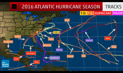
Atlantic Hurricane Season 2016
There is increasing evidence linking rising ocean temperatures to increases in several measures of hurricane activity in the Atlantic since the 1970s. In 2016, warm sea surface temperatures helped to fuel Hurricane Alex, which was the first Atlantic hurricane in January since 1955 and the first storm to form in the month of January since 1938. Then, in late May, warm waters north of the Bahamas gave rise to Tropical Storm Bonnie, an unusual early-season storm that made landfall in South Carolina. In early-August, Hurricane Earl intensified over extremely warm Caribbean waters before hitting Belize as a Category 1 Storm. In early October, Hurricane Matthew surged from a tropical storm to a Cat 5 storm in just 36 hours.

Hurricane ingredients during the 2016 Atlantic season: warm sea surface temperatures and low wind shear?
NOAA's end of May Atlantic hurricane forecast stated there is "uncertainty in the climate signals that influence the formation of Atlantic storms," which makes predicting this season, "particularly difficult."[1]
 Hurricanes rely on warm sea surface temperatures and strong vertical motion in the atmosphere (or low wind shear) to develop. Colorado State University's 2016 Atlantic hurricane season forecast from April 2016 noted there is "significant warmth off the US East Coast," which, other things equal, increases the potential intensity of tropical storms.[2]
Tropical storms also rely on minimal to no wind shear, and climate models are calling for cool neutral to La Niña conditions during the August to October period, which tend to decrease the wind shear over the tropical Atlantic Ocean.
Virtually every measure of Atlantic hurricane activity since the 1970s has increased
There has been a substantial increase in virtually every measure of hurricane activity in the Atlantic since the 1970s, including measures of intensity, frequency, and duration as well as the number of strongest (Category 4 and 5) storms.[3][4] Global warming also concentrates rainfall into extreme events. A warmer atmosphere holds more water vapor, and dumps more precipitation when it does rain, much like a larger bucket holds and dumps more water.
Significant evidence indicates that these increases are linked to higher sea surface temperatures in the region through which Atlantic hurricanes form and move.[5][6][7] However, this is an area of continuing study as numerous factors determine hurricane intensity and frequency, and global warming may be affecting these factors in conflicting ways.
Since 1923, Katrina-magnitude events have been twice as frequent in warm years compared with cold years.[8] By late this century, models project a slight decrease in the annual number of tropical cyclones, but an increase in the number of the strongest (Category 4 and 5) hurricanes.[9] Unfortunately, the trends in resulting damages may not balance out. The damage caused by hurricanes increases geometrically, becoming disproportionately greater as wind speed increases. In addition, almost all existing studies also project greater rainfall rates, with projected increases of about 20 percent near the center of hurricanes.[3]
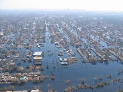
Sea level rise fuels storm surge and flooding
Hurricanes now ride atop elevated sea levels, contributing to storm surge and flooding, the leading cause of hurricane storm damage and fatalities.
Climate-change related increases in sea level have nearly doubled today’s annual probability of a Sandy-level flood recurrence as compared to 1950.[10]
Warm Atlantic sea surface temperatures linked to rare January hurricanes...
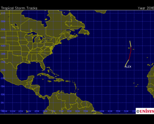
On January 14, Subtropical Storm Alex developed into a hurricane, the first in January since 1955 and the first storm to form in the month of January since 1938.
January 2016 saw two unusual hurricane events—Alex in the Atlantic and Pali in the Pacific—set against extremely warm sea surface temperatures. In the Pacific, the record high sea surface temperatures were driven by a combination of a strong El Niño event coupled with record setting global atmospheric temperatures driven by greenhouse gas emissions. In the Atlantic, El Niño conditions typically suppress hurricane formation.
...and to unusually early activity north of the Bahamas with Tropical Storm Bonnie
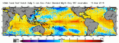
 Late-May water temperatures north of the Bahamas were 1.8°F to 3.6°F (1°C to 2°C) above normal, making sea surface temperatures just warm enough—about 80°F (26.5°C)—for Tropical Storm Bonnie to develop.[11][12]
Global ocean surface temperatures from January through April were also the warmest on record, with a temperature anomaly of 1.46°F (0.81°C) compared to the 20th century average.[13]
Hurricane Earl intensified over warm Caribbean waters
 On August 4, Hurricane Earl made landfall near Belize City as a Category 1 storm with 80mph winds.[14] It was the first Caribbean Hurricane since Hurricane Sandy of 2012 and the strongest hurricane to hit Belize since Hurricane Richard on October 23, 2010.[14]
Earl had the two critical ingredients for intensification: warm sea surface temperatures and strong vertical motion in the atmosphere (or low wind shear). These allowed Hurricane Earl to intensify from a Tropical Storm to a Category 1 Storm just before making landfall in Belize.
Earl encountered light to moderate wind shear of 5 - 15 knots and very warm ocean waters near 86°F (30°C) that were 1.6-2.7°F (1-1.5°C) above the 1971-2000 baseline average.[15][16] The warm waters extended deep below the surface and provided plenty of fuel to power the storm's intensification.[15]
Related Content