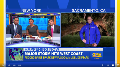
California President's Day Weekend Floods February 2017
On the heels of record-breaking rainfall in January, a series of atmospheric river events brought record rainfall first to Southern and then Northern California in mid-to-late February, causing dangerous flooding, landslides and damaging winds. The winter of 2016-2017 has been one of California's wettest on record, and precipitation since January 1st has led to widespread water-related impacts.
Climate change contributes to both heavy precipitation as well as warmer temperatures that prematurely melt snow pack. The combination of heavy precipitation and snow-pack melt has driven the state from drought to flood. Natural climate variability in California is extremely high. Both drought and flood are part of the natural climate pattern. And climate change contributes to both. As California swings between drought and flood, climate change helps push the pendulum out to either extreme, furthering weather whiplash.
Climate science at a glance
- Extreme precipitation is increasing. This is a global trend that has been clearly documented and firmly attributed to global warming. A warming atmosphere can hold more water vapor. And like a larger bucket that can hold and dump more water, a warmer atmosphere concentrates precipitation into events that are more extreme.
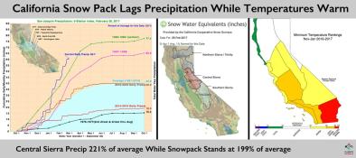
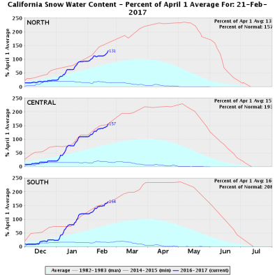
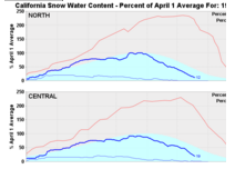
- Warming temperatures prematurely melt snow pack and convert snowfall to rainfall (which also furthers snow pack melt), all contribute to run-off and increasing flood risk.
- Climate change contributes to both flood and drought in California, further polarizing climate conditions, i.e. weather whiplash.
Relentless rainfall drives flooding across California
Two back-to-back atmospheric river storms in mid-to-late February caused record rainfall in California. The storms arrived a week after heavy rainfall in Northern California prompted the evacuation of nearly 200,000 people when flooding damaged both spillways of the Oroville Dam.[1]
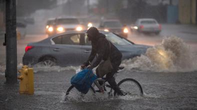
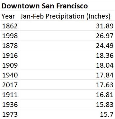
The first round of storms killed seven people and caused flash flooding, mudslides, urban flooding, and debris flows on February 17-18 in Santa Barbara, Ventura and Los Angeles counties.[2][3] Nearly 9 inches of rain fell in the mountains north of Santa Barbara, while in downtown Los Angeles rainfall totals were just short of their daily rainfall record.[2] The low pressure system responsible for the storms may have also set the record for the lowest pressure in the month of February at San Francisco Airport, a record that was last set in 1998.[2]
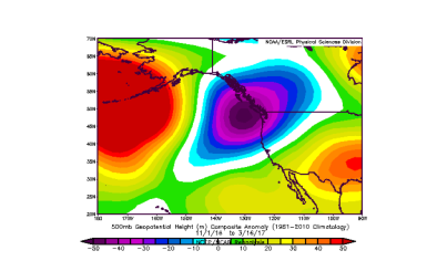
 On February 19-21, a new and powerful storm began in Northern California.[4] The amount of atmospheric water vapor transport near the Interstate 80 corridor on Monday, February 20 was of a magnitude historically seen only once every ten years in February.[5]
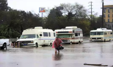
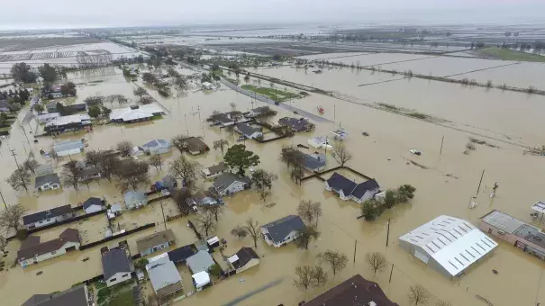
Several areas set new rainfall records on February 20, including San Jose (1.87 inches), San Francisco International Airport (2.16 inches) and Sacramento (1.74 inches).[6] Some areas in the mountains received more than 6 inches of rain and wind gusts up to 199 mph.[7][8] Across California, residents were evacuated when local rivers flooded, including 500 residents in Manteca, a small Northern California town that experienced a levee breach the night of February 20.[9] For the first time in 20 years, the spillway gates of the Don Pedro Reservoir in Tuolumne County were opened Monday as the heavy rain pounded northern California, with some areas receiving more than 8 inches in a 48-hour period.[10]
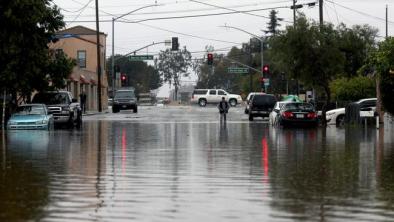
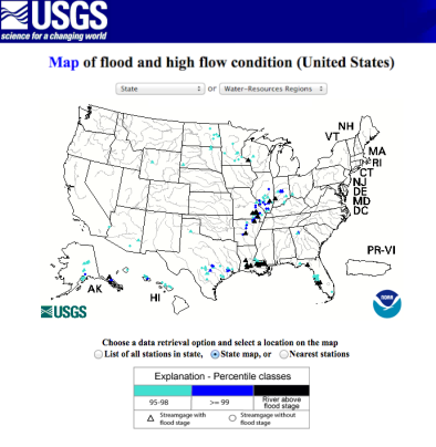
Relentless rainfall, which kicked off with two back-to-back atmospheric river storms the first week of January 2017, has saturated soils in California, causing widespread flooding of streams, smaller rivers, and coastal areas. By February, virtually all rainfall in northern California was generating rapid runoff and flowing into bodies of water already experiencing residually high flows.[11] The winter of 2016-2017 has been one of California's wettest on record, and precipitation since January 1st has led to widespread water-related impacts, including inundation of agricultural lands and low-lying Central Valley communities, mudslides and landslides, roadway failures, and most of California’s major and minor reservoirs are now nearing capacity, requiring large water releases.[4]
Extreme rainfall and warm conditions driving up flood risk
A warmer atmosphere drives more extreme precipitation across all storm types, increasing the risk of flooding.[12] There has been an increase in the intensity and frequency of extreme precipitation events both globally and across the United States.[13] In California, the change in intensity is mostly focused in the northern half of the state, though some Southern California stations such as Los Angeles show changes.[14] In Sacramento, historical analysis reveals a trend toward less light rainfall and more moderate and heavy rainfall in the second half of the 20th century.[14]
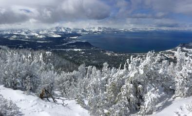
Warming temperatures also convert snowfall to rainfall, which in turn can melt snow pack and increase the risk of flooding.[15][16][17] In 2015, for the first time in 120 years of record keeping, the winter average minimum temperature in the Sierra Nevada was above freezing, a key threshold for maintaining snow pack.[18] 68 percent of weather stations in California between 2,000 and 5,000 feet of elevation are recording a lower percentage of precipitation falling as snow during the winter snow season over the last several decades.[19]
Because winter temperatures in the Sierra Nevada mountains are often near the thawing threshold, a small difference in the temperature of passing weather systems often determines whether precipitation falls as snow or rain.[20] Rain-on-snow-producing atmospheric river storms are, on average, only 2°C warmer than others storm types that preserve snow pack.[20] Weather systems passing through California originate globally, and the average global increase in temperature has been 1°C, indicating significant risk that storms arriving in California may be warming and converting additional snow pack to mountain run-off.
Weather whiplash
Climate change in California is linked weather whiplash—a term for a rapid switch from one type of extreme weather to another, such as extreme drought-flood cycles.
California has the greatest range of natural variability in weather condition in the United states. Flood and drought are both part of California's historical climate.
Climate conditions in California are polarizing further, amplifying the flood/drought pattern that has repeatedly visited the state over the last century.[21][22] Overall basin dryness has increased, due to warming temperatures which dry out soils and amplifies drought conditions. This in turn decreases flood risk.[23] However at the same time, as rainfall is concentrated into extreme precipitation events and as increasingly less precipitation falls as snow, flood risk increases.[13] These trends combine to drive weather toward extremes at either end of the drought/flood spectrum.
Climate models project that the intensity and duration of atmospheric rivers increase in the Golden State in a warming climate, with the most intense atmospheric river storms becoming more frequent.[24][25][26] In addition, the AR season is prolonged and landfall locations change.[27] In looking at recent observations, a detectable signal has not yet arisen out of the background noise made up by natural variability to confirm that climate change is already affecting the frequency of atmospheric rivers storms in California.
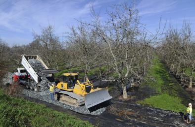
Infrastructure was designed for the climate of the past, not for the rapidly changing climate of the present
Thousands of dams in the US are in need of rehabilitation to meet current design and safety standards.[28] Flooding along rivers, lakes, and in cities following heavy downpours, prolonged rains, and rapid melting of snowpack is exceeding the limits of flood protection infrastructure designed for historical conditions.[12]
Related Content