Chicago Snow Drought Winter 2017
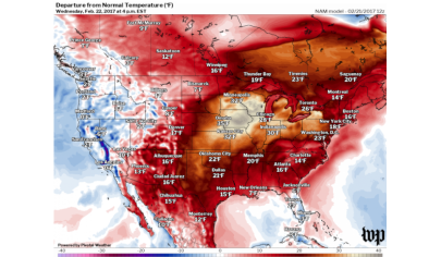
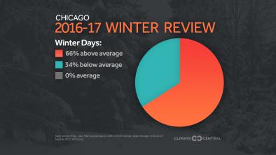
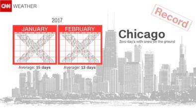
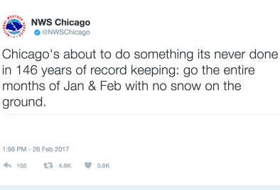
Due to historic and unseasonably warm rainy weather, Chicago witnessed no measurable snow cover for the entire months of January and February for the first time in records dating back to 1884. Christmas morning 2016 was the last day O'Hare International Airport reported at least an inch of snow on the ground. February has been one of Chicago's warmest on record and the city set new daily temperature records. Increasing winter temperatures are one of the clearest signals of climate change.
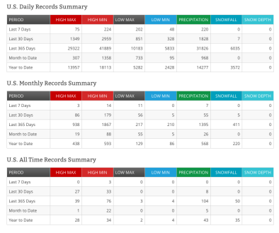
Due to global warming, winters are now warmer and the number of new record high temperatures are far outpacing new record lows. Observed long-term trends towards shorter, milder winters, decreased snow cover, and earlier spring thaws are altering the timing of critical spring events such as bud burst and emergence from overwintering.


Chicago experiences record winter snow drought
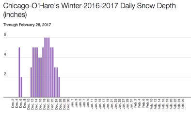
Due to historic and unseasonably warm rainy weather, Chicago experienced no measurable snow cover for the entire months of January and February for the first time in records dating back to 1884.[1] From December 18 through the end of February, Chicago O'Hare Airport measured 0.6 inches of total snowfall, compared to an average if 23.4 inches for this period.[1] Christmas morning 2016 was the last day O'Hare International Airport reported at least an inch of snow on the ground.
February has been one of Chicago's warmest on record. The city set new daily temperature records on four consecutive days from February 17 through 20, with temperatures reaching 67°F, 70°F, 69°F, and 70°F respectively. This was only the fourth and fifth time on record that Chicago reached temperatures exceeding 70°F in February.[2][3]
The unusually warm February weather resulted in early budding of leaves on trees and sprouting plants.[4]
Winter snow drought is tied to record heat and underlying climate shift
In a stable climate, the ratio of new record highs to new record lows is approximately even. However in our warming climate, record highs have begun to outpace record lows, with the imbalance growing for the past three decades. This trend is one of the clearest signals of climate change that we experience directly.[5]
A study examining US trends in record-breaking high and low monthly mean temperatures from 1900 to 2006 finds that February has the most significant excess of record highs, and that the excess is especially pronounced in the Midwest.[6]
Spring snow cover variability is strongly controlled by surface temperature anomalies. Warmer air temperatures, linked to human-caused climate change, have triggered significant reductions in snow cover extent over high northern latitudes during the last 100 years, in particular during the spring season.[7]
A study examining snow season trends across the Northern Hemisphere from 1967 to 2008 finds that snow seasons decreased by 5.3 days per decade, likely due to late winter onset and earlier springs.[8]
Warmer springs advance budburst timing by meeting the heat requirements of plants sooner, and in the Upper Midwest, greenup closely tracks to springtime warming.[9]
Climate simulations for the Midwestern United States indicate warmer-than-normal temperatures and wetter conditions for the snow season (November-April) during the twenty-first century.[7]
Related Content