Great Plains Floods March 2019
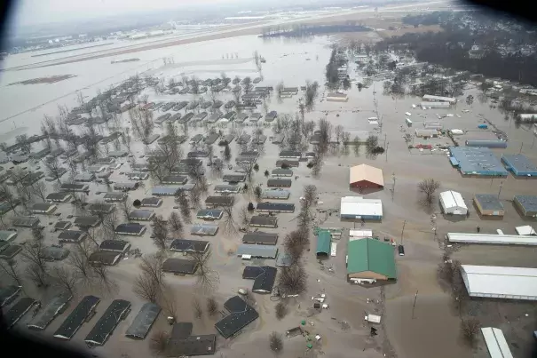
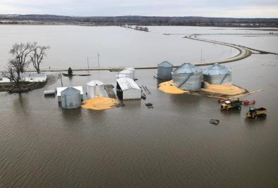
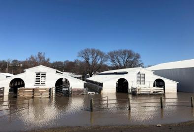
Massive flooding in the Missouri River basin has taken lives and caused billions of dollars in agricultural losses in the Midwest. The immediate cause of the flooding was a late winter storm, a "bomb cyclone," that inundated rivers, causing them to breach (holes in the levee) or overtop (water flowing over the levee) at least two dozen levee systems. The flooding is consistent with the indicators of a planet undergoing global warming.
Climate change increases flood risk in several ways. Warmer than average temperatures can make snow pack melt faster and faster, and cause precipitation to fall as rain instead of snow. A warmer atmosphere can also hold and pour out more water during storms.


Climate science at a glance
- The Great Plains floods reflect the classic signals of climate change.
-
The floods were driven in large part by heavy rainfall and unusually warm temperatures driving rapid snow melt.
-
Warm temperatures also meant that precipitation from the bomb cyclone fell as rain instead of snow, increasing runoff and flood risk.
-
A warmer atmosphere can hold more moisture, and can lead to more intense storms. In the Central U.S., severe storms are showing an increase in intensity and frequency, consistent with climate modeling.
-
Both increasingly warm temperatures and increasingly heavy rainfall are among the clearest signals of climate change.
-
Heavy rainfall is increasing in our warming world, and it is driving up flood risk. Warming temperatures are changing when and how rapidly snow melts.
-
In the Midwest, climate change is driving up total annual precipitation as well, increasing flood risk.
-
Records tend to be broken when climate change contributes to extreme weather. The flood records in the Great Plains were not just broken, they were shattered.
-
The dams and levees that were breached were designed for the climate of the past, not today’s climate.
-
Infrastructure tends to collapse when climate change pushes extreme weather past the limits for which projects were designed.
Climate signal breakdown
Climate signals #1: Extreme precipitation increase
Extreme precipitation is increasing worldwide as the warming atmosphere is holding and dumping more water when it rains. Across the United States, observational data shows an increase in the intensity and frequency of extreme precipitation events.[1]
Midwest, statistically significant increases in flooding are well documented.[2][3][4][5][6][7] These increases in flood risk and severity are not attributed to 20th century changes in agricultural practices, but instead are attributed mostly to the observed increases in total precipitation.[2][8][9][10][11]
Modeling studies consistently suggest that the frequency and intensity of severe storms in the United States could increase with climate change, particularly over the Midwest and southern Great Plains during spring.[12][13][14][15]
Observations consistent with climate signals #1
- During the "bomb cyclone", twice as much rain fell as is normal for the area. The Weather Service’s Omaha office recorded 1.37 inches. More fell to the north and west, with Norfolk, getting 2.27 inches March 12 through 14.
Climate signal #2: Rapid snowpack melt
Global warming affects snow and ice cover by increasing the amount of precipitation falling as rain instead of snow and by hastening snowmelt.
In Nebraska, snow cover has decreased, in part because of warmer temperatures causing earlier melt and increasing the amount of precipitation that falls as rain rather than snow.[16]
A climate change fingerprinting study looking at Northern Hemisphere snow cover extent found that it has decreased primarily due to the earlier onset of spring since the 1970s,[17] and that this decrease is at least partially driven by climate change.[18] As climate change leads to earlier snowmelt and more precipitation falling as rain instead of snow, the risk of major floods increases.
Observations consistent with climate signals #2
-
The weekend of March 9 and 10, temperatures in the Midwest warmed up to the high 30s, and many places experienced widespread snowmelt of two to three inches.[19][20] Some places had the equivalent of six inches of water in 24 hours.
-
Days later, the “bomb cyclone” rolled in, and the warmer temperatures caused rain to fall instead of snow, bringing an additional two inches of water to the region.
Climate signal #3: Runoff and flood risk increase
More intense rainfall events and regional increases in precipitation linked to climate change are increasing the risk of extreme runoff and flooding in some locations. Precipitation is a major driver for river discharge trends and for changes across annual and decadal time scales.
Observations consistent with climate signal #3
- Over 40 locations setting new record river levels, mainly in Nebraska and Iowa.[21]


