Rosa Remnants in the Southwest October 2018
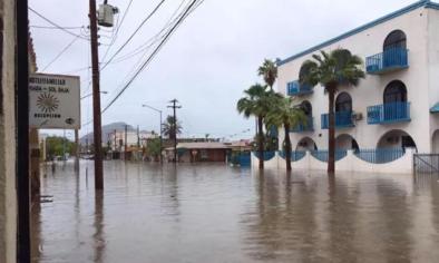
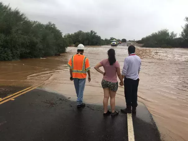
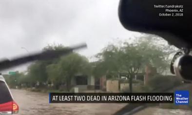
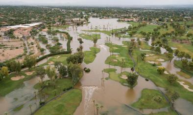
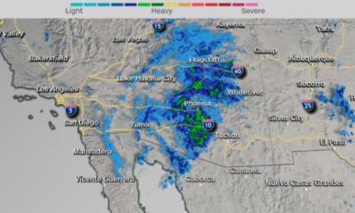
The remnants of Tropical Storm Rosa brought extreme precipitation and flooding to Baja California and the U.S. Southwest the first week of October 2018. At least one person drowned in Caborca, Mexico,[1] and several others had to be rescued from their cars due to flooding in Phoenix,[2] which experienced its wettest October day on record.[3]
In the Southwest, the deluge comes after months of record heat and widespread drought. June through August average temperature in the region was the highest on record,[4] contributing to a spike in drought intensity.[5]
Global warming affects precipitation intensity, increasing flood and runoff risk, and also increases drought risk, which can cause more water to run off the surface when storms occur. This pattern in the West, where extreme dry conditions are punctuated by extreme wet conditions and flooding, is occurring more often and is consistent with climate model projections.[6]
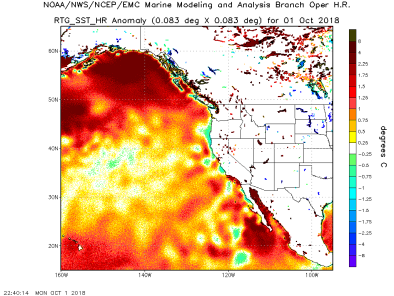
Unusually high sea surface temperatures likely affected Rosa's path. Tropical storms are fueled by available heat, and waters were about 1.8 to 3.6°F (1 to 2°C) warmer than average in the areas Rosa passed through on September 30 and October 1.[7][8][9] Rosa made landfall in Baja California on October 1, unusually far north for an eastern Pacific storm.


Climate science at a glance
- Sea surface temperatures were about 1.8 to 3.6°F (1 to 2°C) above average in the area Rosa passed through on October 1, 2018 and may have contributed to the storms northward movement.[1][2]
- The U.S. Southwest has already begun a long-predicted shift into a decidedly drier climate,[3] increasing the risk of flash floods and mudslides when rains come.
- Average temperature for June-August 2018 in the U.S. Southwest was record warm: 3.3°F (1.8°C) above the 1901-2000 mean.[4]
- The percent area of Arizona in drought has spiked since spring 2018.[5]
- Heavy rainfall rates, like those observed during the storm, are a major risk factor for flash flooding and mudslides, and are consistent with climate change trends. As the air gets warmer, there has been an observed increase in rainfall rates, because warmer air can hold and dump more moisture over shorter periods of time.[6]
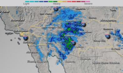
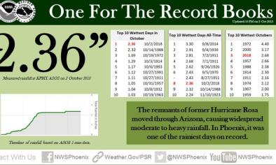
- October 2, 2018 set a new record for wettest October day in Phoenix.[7] By the end of that same day, it was already Phoenix's seventh-wettest October since record-keeping began.[8]
- Las Vegas, NV, set a record at 5 am PDT on the morning of October 2 for the most moisture in the atmosphere on any date in October—and in fact, for any date outside of June through September.[9]
Climate signal breakdown
Climate signal #1: Sea surface temperature increase
Warmer oceans are allowing eastern Pacific storms to reach higher latitudes. This was not the case earlier. It was quite rare for an eastern Pacific storm to even reach Baja California, and this is now becoming more common."
- Gene Norman, freelance meteorologist for CNN[10]
Tropical storms are fueled by available heat. Ocean waters further north are becoming warm enough to sustain them as global warming progresses.
Observations consistent with climate signal #1
- Sea surface temperatures were about 1.8 to 3.6°F (1 to 2°C) above average in the area Rosa passed through on October 1, 2018.[1][2]
Climate signal #2: Drought risk increase
Climate change increases temperature, causing drier surface conditions that increase the risk of flash floods and mudslides.
The southwestern United States has already begun a long-predicted shift into a decidedly drier climate.[3] From 1979 to 2015, human-caused climate change was responsible for more than half of the dryness of western forests and the increased length of the fire season.[11]
Precipitation changes also contribute to the increase in drought risk. A study looking at data from 1979 to 2014 finds up to a 25 percent decrease in precipitation in the US Southwest related to an increase in high pressure, anticyclonic conditions during this time in the North East Pacific.[3] Increased overall dryness is consistent with a trend toward fewer and stronger storms.
Observations consistent with climate signal #2
- Average temperature for June-August 2018 in the U.S. Southwest was record warm: 3.3 degrees F (1.8 degrees C) above the 1901-2000 mean.[4]
- The percent area of Arizona in drought has spiked since spring 2018.[5]
Climate signal #3: Extreme precipitation increase
Extreme rainfall is consistent with climate change trends and increases the risk of runoff.[6] From 1958 to 2016, the amount of precipitation falling in the heaviest events increased by 10 percent in the Southwest.[12] Arizona's landscape, particularly its slot canyons and campsites near creeks, makes it especially vulnerable to flooding.[13]
Observations consistent with climate signal #3
- October 2, 2018 set a new record for wettest October day in Phoenix, with 2.36 inches (5.97 centimeters) of rain recorded at Phoenix Sky Harbor International Airport.[7] It was also Phoenix's eighth-wettest day of all time.[7]
- By the end of October 2, it was already Phoenix's third-wettest October since record-keeping began.[7]
- Las Vegas, NV, set a record at 5 am PDT Tuesday morning for the most moisture in the atmosphere on any date in October—and in fact, for any date outside of June through September.[9]
Climate signal #4: Wildfire risk increase
Recent decades have seen a profound increase in forest fire activity over the western United States.[12] According to climate scientist, Daniel Swain, fires make slopes more susceptible to mudslides when rain comes for a few reasons:[14][15]
- Flames can strip hillsides of plants that would otherwise anchor dirt in place,
- Fires can also physically change the soil, leaving behind a layer of water-repellant dirt near the surface (in part due to the melted remains of the resin-like coat plants in the area have on their leaves),[16] and
- Plants are unable to slow the rate at which rainfall reaches the dirt, leaving more to race down hillsides as runoff.
Any storm that has intensities greater than about 10 millimeters/hour (0.4"/hour) poses the risk of producing debris flows when occurring over fire-scarred areas."
- U.S. Geological Survey
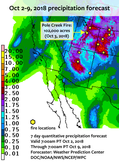
Utah Governor Gary Herbert said areas near burn scars from recent wildfires would be especially susceptible to flash flooding and mudslides after Rosa's rains.[17] The Pole Creek Fire recently burned in an area forecast to receive up to four inches of rain October 2-9, 2018.[18]
Related Content