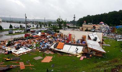
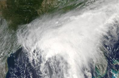
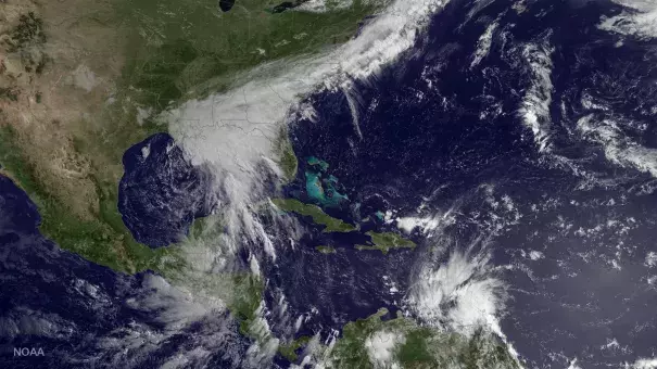
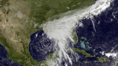
Tropical Storm Cindy June 2017
Climate change means that storms like Tropical Storm Cindy can ride in on higher seas, which worsens storm surge, and dump more moisture over land. The day before Cindy made landfall, areas along the coast east of the Mississippi experienced maximum storm surge of 2 to 4 feet, with a localized maximum of 6 feet at Shell Beach, Louisiana. On June 22, the storm made landfall near the Texas/Louisiana border, bringing more than a foot of rain in some locations.[2]
The fingerprint of global warming has been found in the dramatic increase of extreme rainfall events globally. Climate change is playing a role in changing tropical storms by loading them with additional rainfall. This event comes just a year after several major rain and flood events in the Southeast and Gulf region, including the infamous "unnamed storm" of August 2016 and Hurricane Matthew in October 2016.
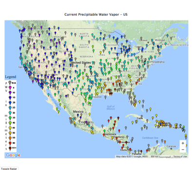
As the atmosphere and oceans warm, the amount of water in the air increases, which fuels more extreme precipitation from all storms, significantly amplifying flooding risk.[1] Precipitable water, a measure of the amount of water in the air, near New Orleans reached 2.6 inches on June 21, one of the highest values recorded in the area for the month of June.
Climate science at a glance
- Global warming is increasing water vapor in the air, which in turn is fueling extreme rainfall, increasing the threat of flooding driven by tropical storms.[1]
- Precipitable water (a measure of the amount of moisture in the air) reached 2.6 inches in the New Orleans area on June 21. This is one of the highest values recorded there in June, consistent with the global and local trend of increasing water vapor driven by global warming.[2][3]
- Increasing surface land and ocean temperatures are increasing the potential energy available to passing storms.[4]
- Sea level rise, combined with coastal storms, has increased the risk of erosion, storm-surge damage, and flooding for coastal communities, especially along the Gulf of Mexico.[5]
- From 1963 to 2012, 88 percent of storm-related fatalities occurred in water-related incidents; storm surge caused 49 percent and freshwater floods due to heavy rainfall caused 27 percent.[6]
One of the clearest changes in weather globally is the increasing frequency of heavy rain
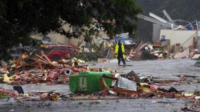
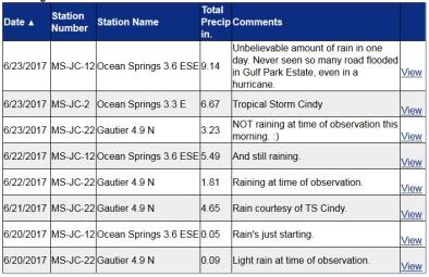
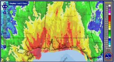
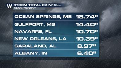
By the morning of June 23, Tropical Storm Cindy had dumped as much as 12.3 inches of rain in Mississippi.[7] According to the US Third National Climate Assessment, the number and intensity of very heavy precipitation events (defined as the heaviest 1 percent of all daily events) have been increasing significantly across most of the United States.[5] In the US, over the past century we have witnessed a 20 percent increase in the amount of precipitation falling in the heaviest downpours.[8]
In the Southeast specifically, the number and intensity of heavy events increased by 27 percent in the Southeast from 1958 to 2012.[5] This event comes less than one year after two other "1,000" year rainfall events struck in the region, the infamous "unnamed storm" of August 2016 and Hurricane Matthew in October 2016, consistent with the increasing frequency of extreme rainfall events globally.
Globally the fingerprint of global warming is now found in 18 percent of the "moderate" (i.e. 1-in-3 year) daily precipitation extremes over land, while a much larger share of very extreme events is attributed to warming.[9]
An April 2017 study found that, from 1961 to 2010, global warming increased the likelihood of occurrence of the wettest five-day periods on record in 41 percent of the observed areas of the world.[10]
"Weaker" tropical cyclones, such as minimal tropical storms, often generate heavier rainfall totals than better-developed tropical storms and hurricanes. This is because weaker tropical storms are not as well-developed vertically, so they do not tap into the upper level winds that would generally allow them to move faster. Slower-moving storms have more time to dump extreme rainfall.[11]
Warmer air can hold and dump more moisture when it rains
Global warming increases the rate at which ocean water evaporates into the air. It also increases the amount of water vapor the air can hold when fully saturated. As the amount of water in the air increases, this causes more precipitation from all storms, which significantly amplifies extreme precipitation and flooding risk.[1]
On Tuesday, June 20, precipitable water (a measure of water vapor) was in historic territory, predicted to reach or exceed 2.5 inches in the New Orleans area.[12] On June 21, observations showed precipitable water values up to 2.6 inches in Grand Isle, Louisiana.[13] Once verified, this will be among the three highest values ever recorded in the region during June.[12] Precipitable water values of more than 2 inches were predicted over most of the Deep South by June 22, helping to fuel very heavy rains.[12]
[C]opious amounts of tropical moisture and very high precipitable water values are being pulled northward 500-600 miles east of [the storm's] center," reported Alabama meteorologist Ryan Stinnett. [14]
The fingerprint of climate change has been found in the increase of wet bulb temperature (a measurement of humidity and heat) since 1973, globally and in most land regions analyzed.[15] The northern hemisphere is tending toward increasingly warmer and more humid summers, and the global area covered by extreme water vapor is increasing significantly.[2] And a recent study has confirmed these earlier results.[3]
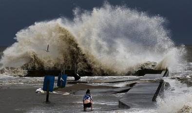
Storm surge inundates coastlines on rising seas
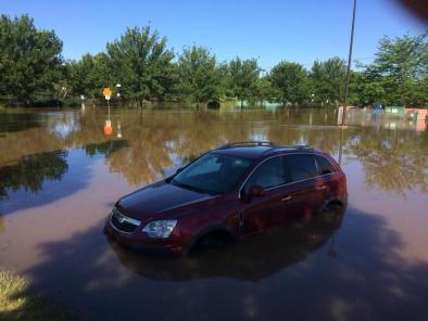
Cindy's storm surge was blamed for the death of a 10-year-old boy who died of injuries suffered when Cindy's storm surge washed a large log onto the shore and struck him.[7]
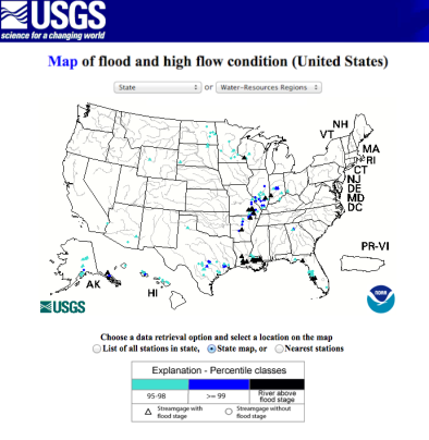
One of the worst impacts of tropical storms in coastal regions is storm surge and coastal flooding. In the case of Tropical Storm Cindy, variation in wind speeds and direction in the atmosphere stretched the storm from a classic hurricane such that the storm couldn't gather as much energy to push a massive storm surge ashore.[16] However, it doesn't require much storm surge to cause serious problems for low-lying states in the Gulf that are already at elevated risk due to sea level rise.
Flooding was already being reported at midday June 20, two days before landfall, in the normally flood-prone parts of Dauphin Island, Alabama.[12] Maximum storm surge, which mostly occurred east of the Mississippi, reached 2 to 4 feet, with a localized maximum of 6 feet at Shell Beach, Louisiana.[19]
A 2014 paper published in the Bulletin of the American Meteorological Society by National Hurricane Center Deputy Director Dr. Ed Rappaport on "Fatalities in the United States from Atlantic Tropical Cyclones," clearly shows the cause of deaths by various storm hazards over a 50-year period.[6] 88 percent of storm-related fatalities occurred in water-related incidents. Storm surge was responsible for about half of the fatalities (49 percent).[6] Another 27 percent resulted from rainfall-induced freshwater floods.[6]
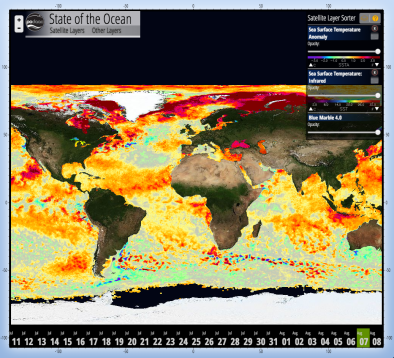
Warmer sea surface temperatures add energy to passing storms
Sea surface temperature increased during the 20th century and continues to rise. From 1901 through 2015, temperature rose at an average rate of 0.13°F per decade, for a total of about 1.4°F (0.8°C).[17][18] Sea surface temperature has been consistently higher during the past three decades than at any other time since reliable observations began in 1880.[17]
s climate change warms sea surfaces, the heat available to power tropical storms increases.[4]
Related Content