Series of atmospheric river storms to bring risk of significant California flooding
One-two (three?) atmospheric river punch will deliver copious precipitation
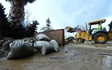
A series of extremely moist Pacific storm systems will take aim at California this week. The first of these is already bringing increasingly heavy rain (and mountain snow) along with gusty winds to much of northern California. This initial system probably won’t cause too many problems outside of some notable travel headaches over mountain passes and perhaps some minor local flooding. But this first round of precipitation will set the stage for bigger problems later this week into next week by saturating the soils north of about Santa Barbara and by depositing multiple feet of fresh snow to the Sierra Nevada, even at more moderate elevations.
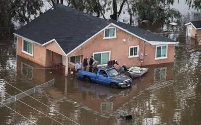
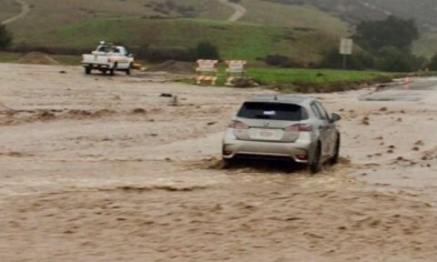
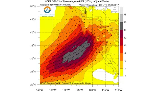
The second storm is (by far) the one of greatest concern, as it will take the form a moisture-laden and slow-moving atmospheric river. While the details with this second system are still somewhat uncertain, virtually all numerical forecast models are painting a very broad area of extremely high precipitation totals over the next 6-7 days across the entire Sierra Nevada mountain chain and also in the coastal mountains from the Oregon border south to Monterey County. It’s still too early to say exactly how much precipitation will fall, but the potential is there for some very impressive numbers–perhaps greater than 20-25 inches along favored western slope regions of the Sierra Nevada and greater than 15 inches in the coastal mountains. Even in low elevation urban areas near the Bay Area and Sacramento regions, 7-day totals exceeding 5-7 inches are entirely possible.
...
This system will also be drastically warmer than its predecessor, and while snow levels could actually start out unusually low (locally in the 2,000-2,500 foot range), they will skyrocket as very strong warm advection occurs Saturday into Sunday. It’s possible that the models are currently presently overestimating the amount of airmass warming that will occur over the weekend, but given the subtropical origins of this atmospheric river snow levels could rise above 9,000 or perhaps even 10,000 feet at the height of the event. This is above essentially all Sierra Nevada passes, and more importantly well above the majority of the recently-fallen snowpack in the 3000-8000 foot range. In fact, 850mb temperatures could rise to around +10C at this time–would would be very bad news indeed for the snowpack. The highest elevations of the Sierra Nevada could see tremendous snowfall totals, likely over 100 inches. And it’s true that storm #1 will drop quite a lot of snow at much lower elevations over the next 24 hours. But much of this snowpack could be erased by 24 hours of warm rain later this weekend.
Related Content