Atlantic Hurricane Season 2020
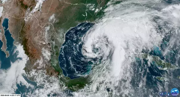
The 2020 Atlantic hurricane season is one for the record books. There were two storms in May, before the season's official start on June 1, and this is the first year since storm record-keeping began in 1851 in which nine named tropical cyclones have formed before August and thirteen before September. Exceptionally warm ocean water, due in part to climate change, is driving the record activity. The most destructive storm in the US so far this season has been Hurricane Laura, which is the strongest landfalling hurricane in Louisiana history and the fifth-strongest hurricane on record to make landfall in the continental US. There are strong ties between climate change and more destructive Atlantic hurricanes.
An active hurricane season is especially dangerous this year because of the compounded public health risks that evacuations or displacements cause as COVID-19 continues to spread and are exacerbated by unemployment and the economic recession. These risks are disproportionately concentrated in low-income communities and communities of color.


Climate science at a glance
- Climate change is fueling extreme rainfall, increasing the threat of rain and flooding driven by hurricanes.
- Hurricanes get their energy by siphoning moisture and energy from warm ocean waters.
- Due to ocean warming, a greater proportion of tropical cyclones around the world are attaining major storm intensity.[1]
- Climate change has been linked to an increase in the frequency of hurricanes in the North Atlantic.[2]
- Sea level rise enables hurricane storm surges to reach further inland and cause more flooding.
- Two factors are driving above-normal activity during the 2020 Atlantic hurricane season: global warming and the current phase of the El Niño Southern Oscillation (ENSO).
- From 2016 to 2018, rain pushed aside storm surge as the top source of hurricane-related deaths.[3][4]
- Infrastructure built to withstand the storms of the past can collapse as new extremes overwhelm and push infrastructure past design thresholds.
- The compounding harms of hurricane impacts amid a global pandemic are disproportionately harming poor communities, black communities, and communities of color.
Background information
What factors influence hurricane development?
Hurricane development requires heat energy from the ocean and low wind shear. Wind shear is often the most critical factor controlling hurricane formation and destruction. In general, wind shear refers to any change in wind speed or direction along a straight line. In the case of hurricanes, wind shear is important primarily in the vertical direction, from the surface to the top of the troposphere. When wind speed and direction changes significantly with height, this creates a shearing force that tends to tear storms apart. Wind shear is often low during the summer and fall from the coast of Africa through the Caribbean where Atlantic hurricanes form, increasing the chance of hurricane formation.
What were recent seasons like and how were communities impacted?
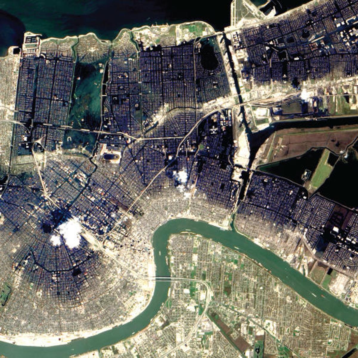
Storms attained Category 5 strength in four straight years from 2016 through 2019 for the first time on record in the satellite era of storm monitoring (dating to the 1960s). 2019's Hurricane Dorian tied for the second-strongest storm recorded in the Atlantic Ocean, with winds of 185 mph. Hurricane Michael in 2018 made landfall at the Florida Panhandle at Category 5 strength making it one of the strongest landfalling hurricanes in US history. In 2017, Hurricanes Harvey, Irma and Maria ranked among the costliest hurricanes in history and affected millions of people in Texas, Louisiana, southwest Florida, North Carolina and Puerto Rico.
The impacts of recent storms disproportionately harmed poor communities, black communities, and communities of color. These communities in the US and elsewhere contribute the least to the emissions that cause climate change but stand to suffer the most because of systemic and structural inequities that keep incomes low, make neighborhoods vulnerable to flooding, and limit access to medical care.[5] Poor people and people of color were disproportionately harmed during Hurricanes Katrina, Harvey, and Florence. Puerto Rico is still recovering from Hurricane Maria.
How is the active hurricane season intersecting with the coronavirus pandemic?
The US emergency response and healthcare systems are facing historic challenges with hurricane season falling in the midst of the coronavirus pandemic. Emergency managers have had to prepare for potential hurricane strikes amid a deadly pandemic and have had to rethink traditional procedures for transporting and sheltering evacuees to maintain social distancing. Hospital evacuations are one of the most disruptive and dangerous threats if COVID-19 and extreme weather coincide. Evacuations could threaten the health and safety of hospital staff and patients, making it difficult to uphold social distancing guidelines and facilitating the further spread of COVID-19. Outside of a pandemic, climate-fueled disasters such as hurricanes can damage healthcare facilities and vehicles, disrupt supply chains for medical supplies and equipment, block essential transportation routes, and destroy patient records—making it harder for health professionals to get to work and for patients to get timely medical care.
Climate signal breakdown
Climate signal #1: Increased storm surge
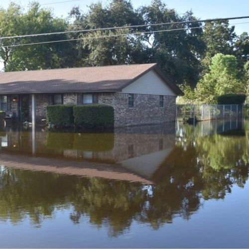
Climate change can lead to increases in storm surge due to rising seas, increasing storm size, and increasing storm wind speeds.[6][7] Historically, storm surge has been the most important impact of tropical cyclones in coastal regions.[6] From 1963 to 2012, storm surge caused 49 percent of hurricane deaths, with rain accounting for 27 percent.[3] However, from 2016 to 2018, extreme precipitation, not storm surge, was the top source of hurricane-related deaths.[4]
Climate change has already contributed about 6.3 inches (0.16 meters) to global sea level rise,[8] and this has dramatically amplified the impact of hurricanes by increasing baseline elevations for storm surge.[9][10][11][12] A small vertical increase in sea level can translate into a very large increase in horizontal reach by storm surge depending upon local topography. Storm surge worsened by climate change increased the area flooded and infrastructure damaged during Hurricanes Florence,[13] Sandy,[10] and Katrina.[11]
Observations consistent with climate signal #1
- Tropical Storm Cristobal's forward pace slowed considerably around the time it made landfall in Louisiana and brought an especially intense storm surge that rendered five miles of the seven-mile-long Grand Isle impassable.
- During Isaias, water levels at the NOAA tide station in Wilmington, NC reached 4.19 feet over normal high tide, breaking the record set during Hurricane Florence in 2018. The water level at Springmaid Pier on Myrtle Beach, SC, climbed more than four feet above the predicted tide, the third-highest water level on record there, behind Hurricane Hugo in 1989 and Hurricane Matthew in 2016.
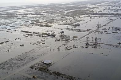
- Peak storm surge when Hurricane Laura made landfall in Cameron, Louisiana is estimated at 12-to-21-feet.
- Storm surge brought by Hurricane Delta climbed to at least 9.3 feet at Freshwater Canal Locks, Louisiana (south-southwest of Lafayette), the highest on record at this location, exceeding the 8.02 feet during Hurricane Ike.
Climate signal #2: Extreme precipitation
One of the clearest changes in weather globally is the increasing frequency of extreme precipitation events. Warmer air can hold more moisture, which increases the amount of water available for storms to dump out as rain.[14] The fingerprint of global warming has been identified in increasing hurricane rainfall rates.[6]
Storms reach out and gather water vapor over regions that are 10-25 times as large as the precipitation area, thus multiplying the effect of increased atmospheric moisture.[14] As water vapor condenses to form clouds and rain, the conversion releases heat that adds buoyancy to the air and further fuels the storm.[15] This increases the gathering of moisture into storm clouds and further intensifies precipitation.[14]
Over the period from 1994-2008, extreme precipitation events linked to hurricanes accounted for more than 33 percent of the observed increase in heavy events across the US.[16] The Southeast in particular saw a 40 percent increase in the amount of precipitation falling in the heaviest events, and 100 percent of this increase is linked to hurricane events.[16]
Scientists have found that global warming increased rainfall for many individual tropical storms and hurricanes, including:
| Ivan (2004) | Katrina (2005) | Sandy (2012) | Harvey (2017) |
 |
 |
:format(png)/cdn.vox-cdn.com/assets/1688223/baanaerialnyc.png) |
:format(jpeg)/cdn.vox-cdn.com/uploads/chorus_image/image/56417705/840239148.0.jpg) |
| [17] | [17][18] | [19] | [20][21][22][23][24] |
| Irma (2017) | Maria (2017) | Florence (2018) | Imelda (2019) |
 |
 |
 |
 |
| [17] | [17] | [25][26] | [27] |
Observations consistent with climate signal #2
- Tropical Storm Cristobal brought rainfall rates of 3 to 6 inches per hour on June 7, triggering significant flash flooding in parts of downtown Jacksonville, Florida, trapping cars.[28]
- Hurricane Hanna dumped over 16 inches of rain in 24 hours in Monterrey, Mexico.
- Isaias rainfall set two flood records in Pennsylvania.
- Hurricane Delta unloaded six to 12 inches of rain between Lake Charles and Alexandria, Louisiana, with localized totals over 16 inches.
Climate signal #3: Intense Atlantic hurricane frequency increase
Due to global warming and the corresponding increase in global ocean temperatures, a greater proportion of tropical cyclones around the world are attaining major storm intensity.[1][29] The close correlation between observed trends in recent sea surface temperatures and observed trends in the intensity of tropical cyclones reflects the link between warming ocean temperatures and stronger storms.[30][31][32]
Scientists have also identified the fingerprint of climate change in the increase in the number of hurricanes occurring in the North Atlantic since the 1980.[2] The Fourth National Climate Assessment states, “Increases in greenhouse gases and decreases in air pollution have contributed to increases in Atlantic hurricane activity [frequency and intensity] since 1970.”[33]
Observations consistent with climate signal #3
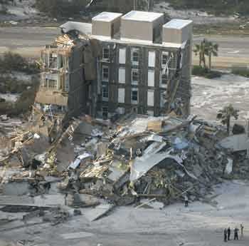
- Hurricane Laura made landfall in western Louisiana as a Category 4 storm with 150 mph winds – the strongest landfalling hurricane in Louisiana history, and the fifth-strongest hurricane on record to make a continental US landfall.
- From 2016 to 2019, the Atlantic basin had the most consecutive years on record with at least one Category 5 storm, topping the last record set from 2003 to 2005.[34]
- On June 7, New Orleans set a new record-low sea-level pressure for the month of June as Tropical Storm Cristobal approached the coast of southeastern Louisiana.[28]
- Isaias was only a Category 1 hurricane when it made a landfall, and a strong tropical storm when it ripped through the Northeast, but it demonstrated that even storms of relatively low intensity can produce enormous impacts. The wind gust measured at the top of Mount Washington, N.H. reached 146 mph, the highest on record there in the month of August.
- November 2020 was the most active of any November on record, including two of the four “Greek” named storms that were so strong they were later retired. This was only the second season on record (the first being 2005) where hurricane names delved into the Greek alphabet, prompting the World Meteorological Organization to announce it would no longer be using Greek names.
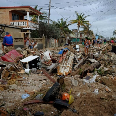
- In the span of 13 days, Category 4 hurricanes Eta and Iota made landfall on Nicaragua’s Caribbean coast just 15 miles apart from each other. It is unprecedented for two Atlantic category 4 hurricanes to make landfall so close together, in such little time. The storms had catastrophic impacts across Central America.
Climate signal #4: Hurricane steering change
Hurricane motion is broadly governed by large scale weather patterns and air flows called steering winds or steering currents. Hurricane steering is one of many measures of hurricane activity in the Atlantic that has changed since the 1970s.[5][35]
Observations consistent with climate signal #4
- Tropical Storm Cristobal's forward pace slowed considerably around the time it made landfall in Louisiana, elevating storm surge.
Climate signal #5: Increase in rapid intensification
Climate change is making dangerous rapidly intensifying hurricanes more common. Many recent Atlantic hurricanes (2020's Laura and also Harvey, Irma, Maria, and Michael) have undergone periods of rapid intensification before making landfall. A study from 2018 shows an increase of 4.4 mph per decade in Atlantic hurricane intensification from 1986 to 2015.[37] A 2019 study similarly shows an increase in rapid intensification during the period 1982 - 2009 and finds the trend can only be explained by including human-caused climate change as a contributing cause.[36] The largest change occurred in the strongest 5 percent of storms: for those, 24-hour intensification rates increased by about 3 – 4 mph per decade between 1982 – 2009.
Observations consistent with climate signal #5
- Hurricane Laura put on a phenomenal show of rapid intensification prior to landfall, increasing in strength by 65 mph in just 24 hours on August 26, 2020. That ties Hurricane Karl of 2010 for fastest intensification rate in the Gulf of Mexico on record. In the 24 hours prior to landfall, Laura’s winds increased by 45 mph.


