California Statewide Heat Wave September 2020
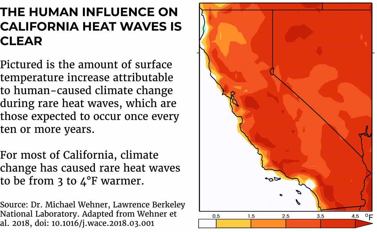
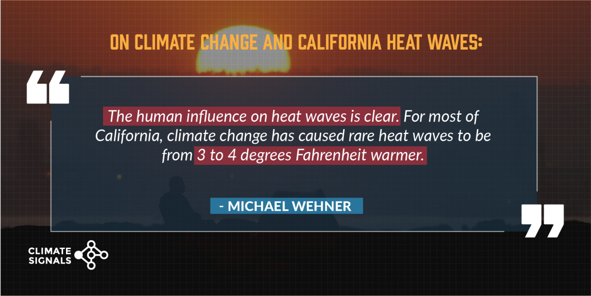
Climate change is exacerbating the "kiln-like" heat wave breaking records across California this early September. Long-term warming means that hot weather patterns, like the high-pressure system and weak sea breeze driving up temperatures in California, can produce unprecedented extremes. By one estimate, temperatures during rare California heat waves are about three to four degrees Fahrenheit warmer than they would have been without human interference in the climate system.
The heat wave is not an isolated incident but part of large-scale trends driven by global warming that are increasing the frequency of extreme events in California and around the world. A similar extreme and record-breaking September heat wave affected California just three years ago. The September 2017 heat wave set monthly and all-time records that are now, once again, being broken. The short-lived nature of these major temperature records is a clear signal of climate change.


Climate science at a glance
- For most of California, climate change has caused rare heat waves to be from 3 to 4 degrees Fahrenheit warmer.
- Half of all record-breaking heat waves would not have broken records without climate change.[1]
- There has been a dramatic increase in hot nighttime temperatures in the US, reducing the number of critically important relief windows during heat waves.[2]
- Global warming contributed to the record for hottest day of the year in at least 82 percent of the records for hottest day over the 1961-2010 period.[3]
- Heat domes increased in intensity over the entire Northern Hemisphere during the summer months from 1979 to 2010.[4]
- For more information on how climate change is exacerbating heatwaves, read here.
Climate signals breakdown
 Climate signal #1: Extreme heat and heat waves
The clearest signal of climate change is the increase in the frequency and intensity of extreme heat events. The trend in global warming has contributed to the severity and probability of 82 percent of record-hot days globally.[3] In California, climate change has caused rare heat waves to be from 3 to 4 degrees Fahrenheit warmer.
As greenhouse gas emissions trap additional heat close to the Earth's surface, temperatures that were once rare become commonplace and the likelihood of seeing extreme and record-hot temperatures increases.
The continued burning of fossil fuels and increasing greenhouse gas emissions means that heat records don't last long as warming continues. Many of the all-time and monthly high temperature records set during the September 2020 heat wave were previously set during a similar heat event in September 2017.
Observations consistent with climate signal #1
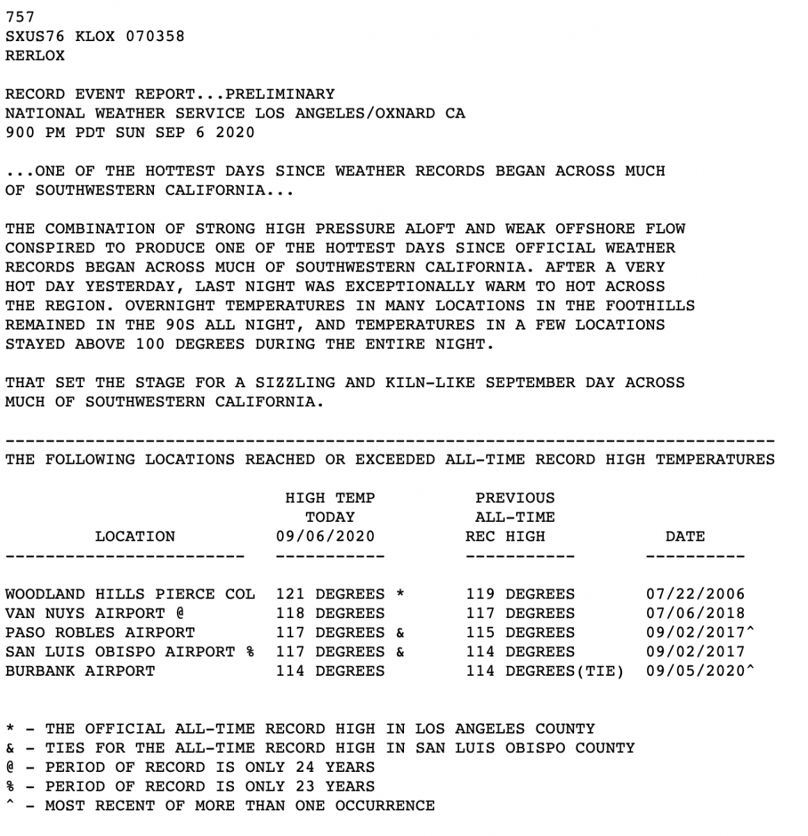
- Eight locations in the Los Angeles/Oxford National Weather Service forecast region set all-time September high temperature records on September 6, 2020. Five of these locations set their all-time maximum high temperature record for any date of the year including Woodland Hills, Van Nuys, Paso Robles, San Luis Obispo, and Burbank. The Woodland Hills record of 121°F is the official all-time record high in Los Angeles country. The Paso Robles and San Luis Obispo records, both 117°F, beat the previous records set during the September 2017 heat wave of 115°F and 114°F respectively.
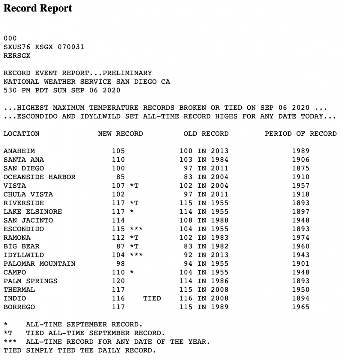
- Eight southern California locations in the San Diego NWS forecast region set all-time September high temperature records on September 6, 2020, including Riverside and Vista. Two locations, Escondido and Idyllwild, set all-time records for any date of the year at 115°F and 104°F respectively.
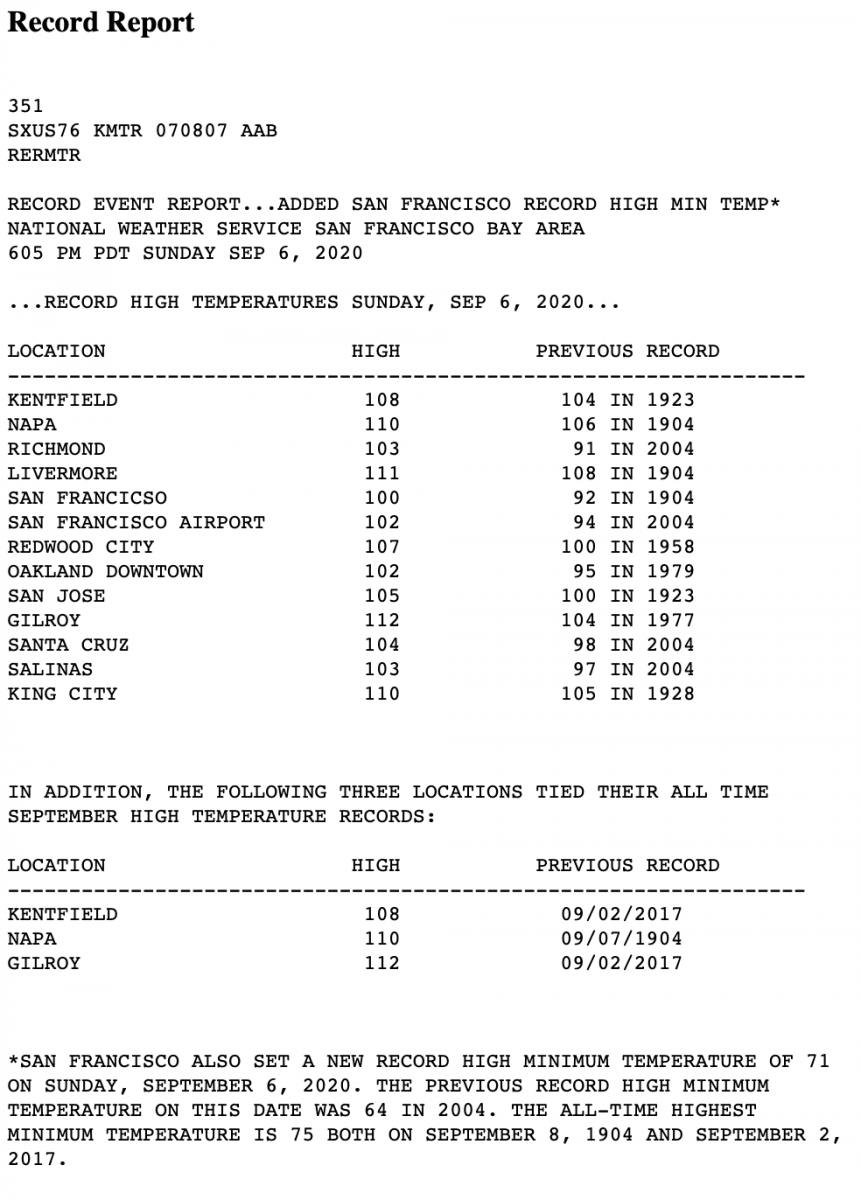
- In the San Francisco Bay Area, Kentfield and Gilroy tied their all-time September high temperature records on September 6, 2020 at 108°F and 112°F respectively. Both locations share the high temperature record with September 2, 2017. Napa set its all-time September high temperature record on September 6, 2020 at 110°F.
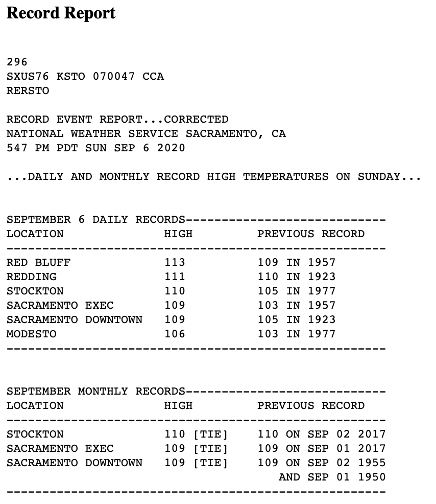
- Sacramento and Stockton tied their all-time September high temperature records on September 6. The high temperature record is shared with records set during the September 2017 heat wave.
Climate signal #2: Heat Stress Increase
Exposure to extreme heat is already a significant public health problem and the primary cause of weather-related mortality in the US.[5] As temperatures rise due to global warming, people's exposure to extreme heat conditions increases.[6] The dramatic increase in nighttime temperatures in the US is particularly concerning, because cooler nighttime temperatures provide an important window of relief during heat waves.[2]
Heat is especially dangerous with high humidity, because it reduces the human body's ability to cool off by sweating. The Heat Index, also known as the "real feel" temperature, is a measure of how hot it really feels when relative humidity is factored in with the actual air temperature. As air warms, its capacity to hold water vapor increases, and measurements show that atmospheric humidity is increasing around the globe.[6] In the US, humid heat extremes doubled in frequency from 1980-1999 to 2000-2019 in most regions.[7]
Observations consistent with climate signal #2
- In the foothills north of Los Angeles, overnight temperatures on September 5-6 remained in the 90s in many locations, with a few locations staying above 100°F.
- A 41-year-old woman died after hiking in extreme heat in the Santa Monica Mountains on September 5 with temperatures above 110 degrees.
Climate signal #3: Atmospheric blocking increase
The widespread and intense heat wave is due to a stagnant high pressure weather pattern that has created a vast area of sweltering heat sometimes referred to as a "heat dome." Intense heat domes used to be rare but have increased dramatically in recent years, a trend that may be linked to human-caused climate change. An analysis of data since 1958 shows that almost all high-powered heat domes have occurred since 1983 — with the overwhelming majority of them occurring since 1990.
Heat domes are often the result of blocks in the jet stream when the west-to-east movement of weather slows or stops. Atmospheric blocking causes weather conditions to persist for long periods and is often behind weather extremes in the mid-latitudes.[8] Research indicates that rising temperatures may increase the frequency of atmospheric blocking events.[9] One analysis identifies an increase in the intensity of persistent high pressure areas over the entire Northern Hemisphere during the summer months from 1979 to 2010.[4]
Observations consistent with climate signal #3
- According to the Washington Post, forecasters expected an extremely rare number (598) indicating heat dome strength on Sunday, September 6. "That describes the height in dekameters, or tens of meters, that the halfway point of the atmosphere’s mass is above the surface. When air warms, it expands. When it cools, a volume of air shrinks. An air mass this hot expands a lot, causing a column of air to grow and raising the atmosphere’s halfway point. With this particular system, that level is 5,980 meters — or about 19,000 feet — above the surface. Elsewhere across the western United States, the number will be higher, at or above 6,000 meters, or about 19,700 feet, above the surface."
Related Content


