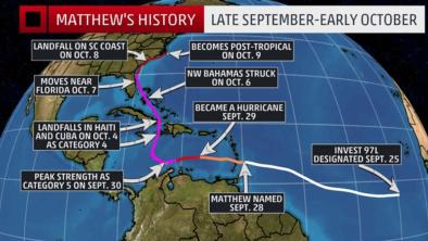
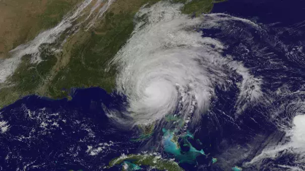
Hurricane Matthew 2016
After a catastrophic landing in Haiti and then soaking Florida, Hurricane Matthew made landfall on the southeast coast of the United States on October 8, 2016, unleashing record-breaking rainfall and storm surge and driving historic flooding and destructive winds along the coasts of Florida, Georgia, the Carolinas, and Virginia.
Matthew set records for storm tide at multiple locations along the Southeastern United States, aided by sea level rise which significantly extended the reach of the storm surge. Record breaking rainfall was fueled in part by record-breaking levels of atmospheric moisture above the Southeastern US, reflecting the process by which climate change drives extreme precipitation. As global temperature increases, the capacity of the atmosphere to hold and dump more water grows. At the same time warming of the oceans increases evaporation, making more moisture available to the atmosphere.
Matthew loosed an epic deluge in the Caribbean with one weather station in the Dominican Republic recording over 22 inches of rainfall over just 13 hours. Unusually warm seas also fueled Matthew's rapid intensification and sustained the hurricane which broke the record for maintaining Cat 4/5 strength in October. Matthew first spun up into a hurricane on September 29, surging from a tropical storm into a Category 5 hurricane in just 36 hours, a stunning development consistent with the observed trend toward rapidly intensifying tropical cyclones.


Science at-a-glance
- Sea level rise is increasing the reach of storm surge and flooding driven by hurricanes.
- Global warming loads hurricanes with more rainfall, increasing the threat of flooding.
- Hurricanes are growing stronger. There is a significant risk global warming is driving that trend.
Sea level rise fuels storm surge and flooding
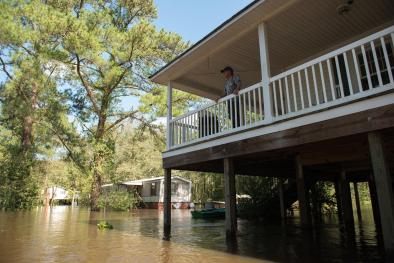
Hurricanes now ride atop elevated sea levels, contributing to storm surge and flooding, the leading cause of hurricane storm damage and fatalities.
Elevated by sea-level rise, record-breaking storm tide (water level, measured relative to high tide) driven by Matthew was documented at three of the ten tide gauges with long-term records along the coasts of northern Florida, Georgia, South Carolina, North Carolina, and Virginia. Wilmington, NC, witnessed 3.53 feet of storm surge, beating the prior record set during Hurricane Hazel on October 15, 1954. Near record-levels were recorded at three other stations.[1]
Sea levels are now 8 inches higher due to sea level rise,[2] an increase that drives flooding much further inland along low-lying areas such as much of the southeastern US coastline.[1] NOAA reports that so-called "nuisance flooding," e.g. coastal flooding during king tides, has already increased 300 to 925 percent due to sea level rise to date.[3] A small vertical increase in sea level can translate into a large increase in horizontal reach by storm surge depending upon local topography. For example, sea level rise extended the reach of Hurricane Sandy by 27 square miles, affecting 83,000 additional individuals living in New Jersey and New York City.[4]
St. Augustine, the 511-year-old tourist town in northern Florida, was swamped by a record-breaking nine-foot combination of surge and high tide, as was Tybee Island off Georgia, where high tide and the storm surge coincided to inundate the low-lying barrier island.[5]
Matthew caused total economic losses in the United States of up to 10 billion US dollars and losses of more than 5 billion in Haiti, Cuba and the Bahamas.[6] The official US death toll was 49, including 28 in North Carolina alone.[6]
Global warming is supercharging rainfall
Matthew unleashed epic deluges in the Caribbean and the Southeast United States, including widespread 1-in-1,000 year rainfall across the Carolinas. Record-breaking rainfall was recorded in Georgia, the Carolinas and Virginia. In Fayetteville, NC, 14.00 inches of rain was reported on October 8, demolishing the city’s previous all-time calendar-day record of 6.80 inches observed during Hurricane Floyd on September 16, 1999.[1] In the Dominican Republic one personal weather station recorded over 22 inches of rainfall over just 13 hours.[7]
By Oct 13, peak streamflow records broken for at least 14 sites in North Carolina and additional flooding was expected to set more records as floodwaters gathered downstream.[8]
72 hr rainfall: The gradients, the amounts, it all still blows my mind.
- Brad Panovich, Chief Meteorologist WCNC NBC Charlotte
The storm swept in by Hurricane Matthew produced rainfall that exceeded the level expected about once every 1,000 years, according to a statistical analysis conducted by the National Oceanic and Atmospheric Administration data.[9][10]
One of the clearest changes in weather globally is the increasing frequency of heavy rain.[11] Over the past century the US has witnessed a 20 percent increase in the amount of precipitation falling in the heaviest downpours. Over the period from 1994-2008, extreme precipitation events linked to hurricanes accounted for more than 33 percent of the observed increase in heavy events across the US.[12] The Southeast in particular saw a 40 percent increase in the amount of precipitation falling in the heaviest events, and 100 percent of this increase was linked to hurricane events.[13]
The increase in extreme precipitation has increased the threat of flooding. Inland cities near large rivers in the US are now experience more flooding, and this shift is consistent with climate change.[2]
As the global average temperature increases, so too does the ability of the atmosphere to hold and dump more water when it rains.[14] Atmospheric water vapor has been increasing.[15][16] And the observed increases have been studied and formally attributed global warming.[17][18][19]
Storms reach out and gather water vapor over regions that are 10-25 times as large as the precipitation area, thus multiplying the effect of increased atmospheric moisture.[14] As water vapor condenses to form clouds and rain, the conversion releases heat that adds buoyancy to the air and further fuels the storm.[20] This increases the gathering of moisture into storm clouds and further intensifies precipitation.[14]
Over the last three decades, extreme and record-breaking rainfall events have significantly globally, and the fingerprint of global warming has been firmly documented in this pattern. Climate change is now responsible for 17 percent of moderate extreme rainfall events, i.e. 1-in-3 year events. The more extreme the event, e.g, 1-in-30 year events, the more likely climate change is responsible, as climate change affects the frequency of the extreme events the most. [21][22]
The record breaking deluge along the Southeastern US was fueled in part by record-breaking levels of atmospheric moisture. Jacksonville, FL, and Charleston, NC, recorded record-high levels of atmospheric moisture on October 7 and 8 respectively.[1]
Unusually warm seas also helped to load moisture into Matthew which drew from a broad region of anomalously warm waters to funnel in moisture at an "astronomical" rate.[23][24]
Matthew no doubt rained more than an identical storm would have 30 or 40 years ago because it is warmer.”
Kerry Emmanuel, Massachusetts Institute of Technology[10]


Matthew grew extremely quickly into a major hurricane
Over the course of 36 hours, Matthew surged from a tropical storm into a Category 5 hurricane, fueled by seas warmer than the historical average.[25] This surge is consistent with the observed trend toward rapidly intensifying tropical cyclones, particularly in the North Atlantic and Caribbean.[26][27] Matthew's 80 mph intensification in 24 hours was the 3rd strongest rapid intensification in the Atlantic on record (trailing Wilma in 2005 and Felix in 2007).[28]
We definitely had a warm ocean. The ocean in the Caribbean right now is warmer than normal for this time of year, and the warmth extends to great depths. It's likely a portion of the warming is due to human activity — [so-called] anthropogenic climate change.
James Done, National Center for Atmospheric Research[29]
Matthew maintained Category 4-5 hurricane strength for 102 hours in October - the longest that a hurricane has maintained Category 4-5 strength on record during October in the Atlantic.[29][28]
 Matthew's tremendous power and sustained strength are consistent with the observed trends in the Atlantic since the 1970's.[2]
Globally, the proportion of Category 4 and 5 hurricanes has increased at a rate of 5–30 percent per °C of global warming. This shift has been balanced by a similar decrease in Category 1 and 2 hurricane proportions. There is a significant risk that this trend is driven by global warming.[30][31]
The trend toward increasingly rapid intensification of hurricanes may be linked to the increasing frequency of the strongest hurricanes, as the vast majority of major cyclones are storms that intensify rapidly.[32]
Matthew generated the most Accumulated Cyclone Energy in eastern Caribbean of any hurricane[33] and ranks 8th among all Atlantic hurricanes, during the satellite era (when such records are available).[28]
We expect to see more high-intensity events, Category 4 and 5 events, that are around 13 percent of total hurricanes but do a disproportionate amount of damage. The theory is robust and there are hints that we are already beginning to see it in nature.
Kerry Emanuel, professor of atmospheric science, MIT[34]
Virtually every measure of Atlantic hurricane activity since the 1970s has increased
There has been a substantial increase in virtually every measure of hurricane activity in the Atlantic since the 1970s, including measures of intensity, frequency, and duration as well as the number of strongest (Category 4 and 5) storms.[11][35]
Tropical cyclones are fueled by available heat. Warming seas are increasing the potential energy available to passing storms, effectively increasing the power ceiling or speed limit for these cyclones.[36] However, other factors, such as wind shear and the global pattern of regional sea surface temperatures, also play controlling roles. And the balance of these factors is not fully known.[37]
As seas warm and offer more heat energy, there has also been a global increase in the observed intensity of the strongest storms. The close correlation between observed trends in recent sea surface temperatures and observed trends in the intensity of tropical cyclones may reflect a causal link between warming ocean temperatures and stronger storms.[38][39] The increases are well-documented and are consistent with model projections for cyclones in a warming climate, but work continues to better understand the relation between these two trends.[36] However there is significant risk that these two trends are, in fact, causally related.
The US National Climate Assessment (2014) reports that "the intensity, frequency, and duration of North Atlantic hurricanes, as well as the frequency of the strongest hurricanes, have all increased since the early 1980s." Significant evidence indicates that these increases are linked to higher sea surface temperatures in the region through which Atlantic hurricanes form and move.[38][40][41] However, this is an area of continuing study as numerous factors determine hurricane intensity and frequency, and global warming may be affecting these factors in conflicting ways.
For the most recent, detailed, consensus synthesis of the current science on climate change and tropical cyclones see, "Tropical cyclones and climate change," by Walsh et al, 2015.[36]
We know that the warmer the ocean surface, the more moisture and heat that's available to intensify hurricanes and typhoons.
Dr. Michael Mann [42]
If you put more heat energy into the air, you've got more energy available to power a stronger storm.
Dr. Jeff Masters [42]
The thermodynamic limit for this hurricane wind speed must go up as you warm the climate.
Dr. Kerry Emanuel [42]
Looking forward, there is a uniform projection by climate models that the frequency of the strongest cyclones will increase. Most models also project that the overall number of cyclones will decline even as the frequency of the most powerful storms increases. Unfortunately, these opposing trends may not balance out. The damage caused by hurricanes increases geometrically, becoming disproportionately greater as wind speed increases. Moreover, some results point to an increase in frequency across all storms.[36][43][44] There is a large uncertainty in these projections[36] which represents considerable risk.
Related Content