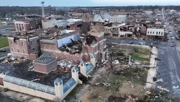
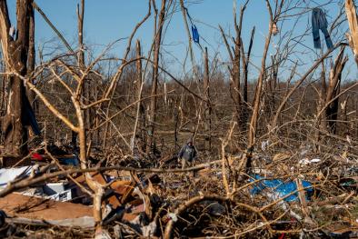
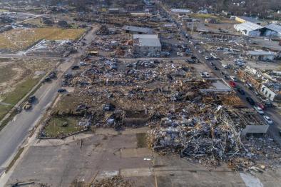
Midwestern and Southeastern Tornado Outbreak December 2021
A major tornado outbreak of at least 50 tornadoes struck America's Heartland the night of December 10, including at least one long track tornado that may have been on the ground for more than 200 miles across four states. Homes and businesses were destroyed across eight states, including Arkansas, Illinois, Indiana, Mississippi, Missouri, Ohio, and Tennessee, as well as Kentucky where the devastation was most severe. It's likely that at least 100 people died. There is increasing evidence linking climate change to the severe weather that gives rise to tornadoes and emerging research suggests there may be a link between warming and large tornado outbreaks, particularly in the southeast U.S. in the winter months. Additionally, Tornado Alley is shifting east, away from Kansas and Oklahoma toward the states hit Friday night.
Climate science at a glance
- There’s increasing evidence linking global warming to changes in the type of severe weather that gives rise to tornadoes.
- While the direct impact of climate change on tornadoes is not well established, we know that thunderstorms and tornadoes occur to stabilize the atmosphere, and global warming can increase instability.
- The latest science supports a link between warming and large outbreaks, particularly in the southeastern US in the winter months.
- Tornado frequency is increasing in some regions and the seasonality of when tornadoes form is shifting.
“Last night was one of the most shocking weather events in my 40 years as a meteorologist — a violent tornado (in December!) drawing comparisons to the deadliest and longest-tracking tornado in U.S. history."
Jeff Masters, a meteorologist and extreme weather expert
Background
How do tornadoes form?
Tornadoes take shape under particularly specific atmospheric conditions, but are primarily fueled by warm, moist air from strong winds that shift direction with altitude.
All thunderstorms need the same ingredients: moisture, unstable air and lift. Lift is the upward motion of unstable air due to the density difference between warm, moist air that has absorbed enough heat to make the air less dense than the cooler, dryer surrounding air. Lift commonly occurs along cold fronts and creates tall thunderstorm clouds as the unstable air rises. A common measure of the instability of the atmosphere and the potential for lift, is a quantity known as CAPE — or Convective Available Potential Energy. It’s calculated by determining the extent to which a pocket of air’s density will allow it to rise.
In addition to lift, tornadoes require spin. Air rising in thunderstorms can begin to spin if wind speeds increase and change direction with height as you go up in altitude. This change in wind speed and/or direction with height is known as wind shear. Wind shear creates spin, and more wind shear creates more spin, which increases the risk of tornadoes. Air that spins as it rises is typical in supercells, the strongest type of thunderstorm, but not all spinning air creates a tornado. Tornadoes only form when thunderstorms have a particular combination of winds.
How does climate change increase tornado risk?
Recent research finds a link between global warming and an increase in the atmospheric instability that fuels thunderstorms. There are also statistically significant winter trends over much of the south central and southeastern US in tornadogenesis metrics including CAPE and wind shear (see section above for more on these). Observational data also shows that tornado frequency has increased over the past four decades in much of the Midwest and Southeast, while decreasing in parts of the central and southern Great Plains, a region traditionally known as "tornado alley."
"The research landscape has changed, & there's now more evidence than 5-10 years ago."
Daniel Swain, climate scientist at UCLA
"When you start putting a lot of these events together, and you start looking at them in the aggregate sense, the statistics are pretty clear that not only has there sort of been a change -- a shift, if you will -- of where the greatest tornado frequency is happening. But these events are becoming perhaps stronger, more frequent and also more variable."
Victor Gensini, Associate Professor at Northern Illinois University
Climate signals breakdown
Climate signals #1 and #2: Atmospheric Moisture Increase and Storm Intensity Increase
The most basic connection between global warming and increased tornado risk is the influence that warming has on the instability of air near the ground, which is what drives the upward motion of air and thunderstorms in the first place. Warm and moist conditions are the key for unstable air. It follows that more heat and water in the atmosphere and warmer sea surface temperatures increase the risk for stronger storms.
Observations consistent with climate signal #1 and #2:
-
Record warm temperatures in much of the country and La Niña conditions created ideal conditions for a turbulent event.
-
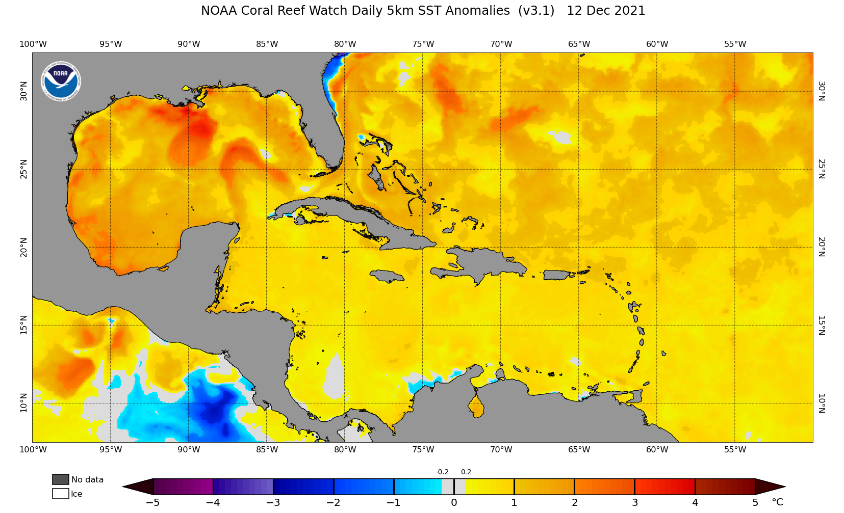
Sea surface temperatures in the Gulf of Mexico on December 10, 2021 were well above average average. See image below. The mean climatology has a baseline, reference, time period of 1985-1990 plus 1993.
"This is going to be our new normal," FEMA Administrator Deanne Criswell told CNN. "The effects we are seeing of climate change are the crisis of our generation."

Rose Andreatta
Rose Andreatta is the director of the Climate Signals project and has over a decade of experience translating scientific information into usable formats for a variety of audiences. Rose earned her Master’s of Public Administration in Environmental Science and Policy at Columbia University and holds a Certificate of Achievement in Weather Forecasting from Pennsylvania State University.


