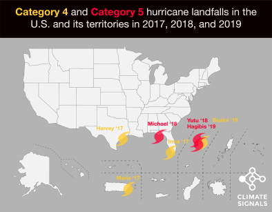
Hurricane Harvey 2017
Climate change raises or amplifies the three primary hazards associated with hurricanes: storm surge, rainfall, and the power ceiling, aka potential speed limit, for hurricane winds.
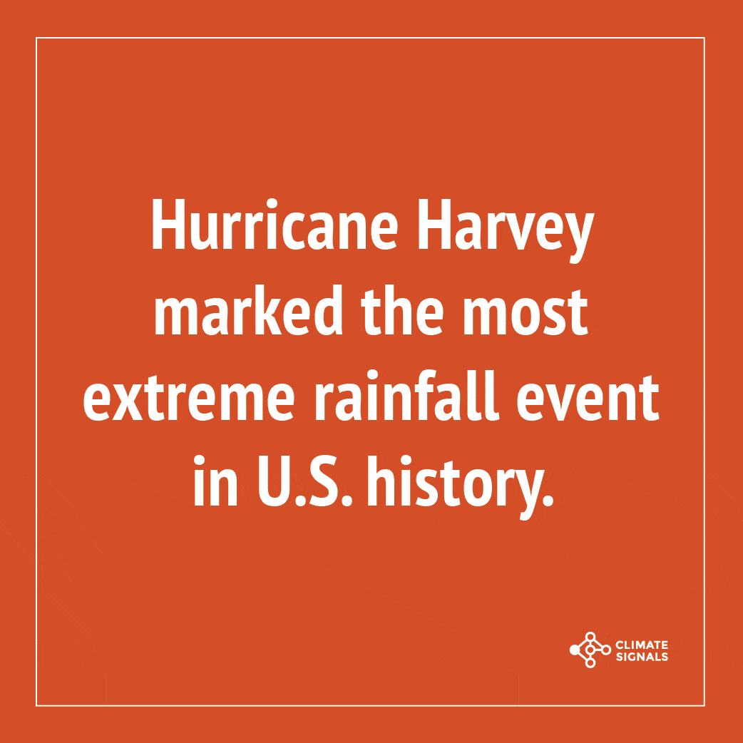
In the case of Hurricane Harvey, extreme precipitation was most notable. Harvey set a new national tropical cyclone rainfall record of 60.58 inches near Nederland, Texas.[1] At least five attribution studies found that global warming added to the deluge of rainfall dumped by Hurricane Harvey., and climate change was responsible for up to $67 billion of Harvey's $90 billion price tag.[2] A warmer atmosphere holds more water vapor, feeding more precipitation into all storms including hurricanes, significantly amplifying extreme rainfall and increasing the risk of flooding.[3][4]
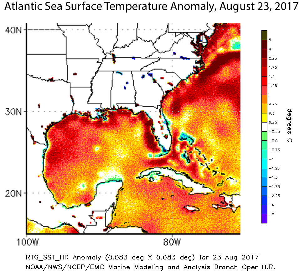
In addition to extreme precipitation, Harvey intensified rapidly amid sea surface temperatures in the Gulf of Mexico up to 2.7 - 7.2°F (1.5 - 4°C) above average, relative to a 1961-1990 baseline.[5] As climate change warms sea surfaces, the heat available to power hurricanes has increased, raising the limit for potential hurricane wind speed and with that an exponential increase in potential wind damage.


Climate science at a glance
- Five attribution studies have found that global warming added to the deluge of rainfall dumped by Hurricane Harvey.[1][2][3][4][5] One of them estimated that climate change increased Harvey’s rainfall by 38 percent.[3]
- Climate change is responsible for $30-$67 billion of Hurricane Harvey's $90 billion price tag.[6]
- Global warming is increasing water vapor in the air, which in turn is fueling extreme rainfall, increasing the threat of flooding driven by hurricanes.[7]
- Sea level rise, combined with coastal storms, has increased the risk of erosion, storm-surge damage, and flooding for coastal communities, especially along the Gulf of Mexico.[8]
- From 1963 to 2012, 88 percent of storm-related fatalities occurred in water-related incidents; storm surge caused 49 percent and freshwater floods due to heavy rainfall caused 27 percent.[9]
- Harvey intensified rapidly in the Gulf of Mexico, aided by sea surface temperatures up to 2.7 - 7.2°F (1.5 - 4°C) above average relative to the temperature average from 1961-1990.[10]
- Increasing sea surface temperatures are increasing the potential energy available to passing storms.[11]
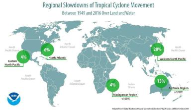
- Harvey's rapid intensification is consistent with the observed trend toward rapidly intensifying tropical cyclones, particularly in the North Atlantic and Caribbean.[12][13]
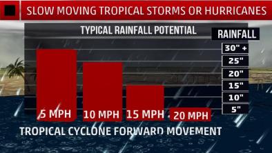
- The kind of stalled weather pattern that amplified rainfall in southeastern Texas Houston is the sort of pattern expected due to climate change.[14]
Hurricane Harvey's intensification and impacts
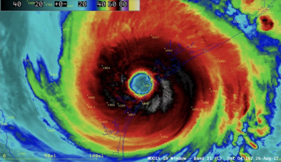
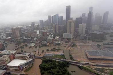
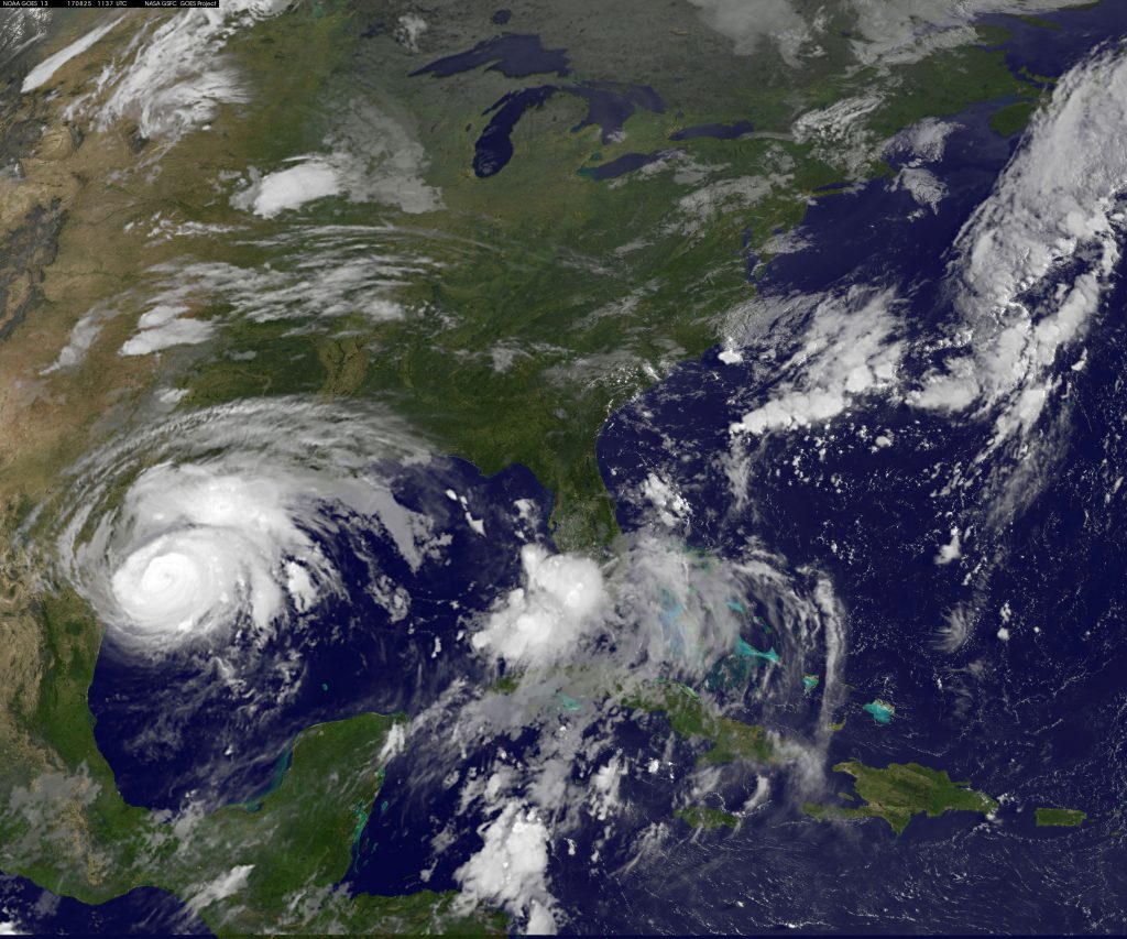
In just 57 hours, Harvey intensified from a regenerated tropical depression into a Category 4 hurricane, making landfall northeast of Corpus Christi Texas on August 25 with wind speeds of 130 mph.[15] As wind speeds lowered on August 26th, Harvey was downgraded to a tropical storm but remained destructive.[16] The storm's center moved back out over the Gulf of Mexico and made a second landfall just west of Cameron, Louisiana on August 30th.[17] By the morning of the 31st, Harvey had dumped an estimated total of 24.5 trillion gallons of water on Southeast Texas and southern Louisiana.
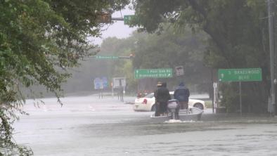
In all, Hurricane Harvey delivered wide-spread 25,000-year rains over a 120-hour period, and isolated locations witnessed 500,000-year rains over a 120-hour period.[18] Mass destruction of property, unprecedented flooding, and widespread power outages occurred in Southern Texas as a result.[19][20] After a loss of power at a chemical plant, failing refrigeration units led to fires and explosions in Crosby, Texas. Eighty-eight deaths are related or suspected to be related to the storm.
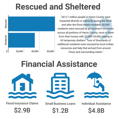
Estimated losses due to Harvey are $125 billion. Harvey was one of 16 extreme weather events in 2017 that together cost a record $306 billion dollars. 2017 broke the previous record set in 2005, when Hurricane Katrina and other disasters caused $215 billion in damage to the U.S. To put this in context, total government spending in 2017 was about $3.65 trillion. This means 16 extreme weather events cost the equivalent of 8 percent of all government expenditures in 2017.
Storm surge inundates coastlines on rising seas
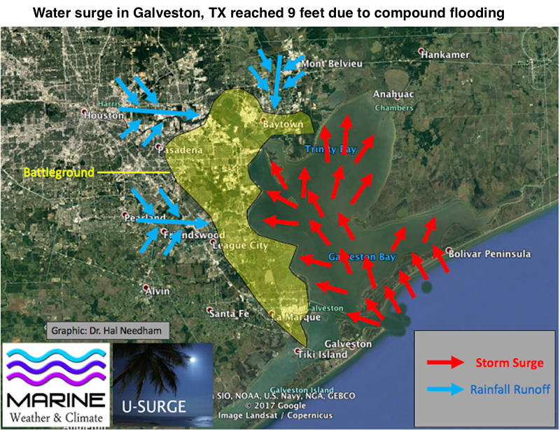 Hurricanes now ride atop elevated sea levels, contributing to storm surge and flooding. While Harvey’s storm surge was not nearly as extreme as the observed rainfall, the two combined to create what is known as “compound flooding.”[21][22] Rivers rushing toward the Gulf coast met the storm surge coming inland and water “piled up from both sides."[21]
In Galveston, the sea surge was about 3 feet, but the actual water surge was about 9 feet due to compound flooding.[21] In terms of pure storm surge, 7.0 feet above Mean Sea Level (MSL) was observed at Port Lavaca - the highest storm surge in that location since Hurricane Carla in 1961.[23]
Sea levels are now 8 inches higher due to sea level rise,[8] an increase that drives flooding much further inland along low-lying areas such as much of the Gulf of Mexico coastline. A small vertical increase in sea level can translate into a very large increase in horizontal reach by storm surge depending upon local topography. For example, sea level rise extended the reach of Hurricane Sandy by 27 square miles, affecting 83,000 additional individuals living in New Jersey and New York City[24] and adding over $2 billion in storm damage.[25] Aided by sea level rise, Hurricane Matthew set several storm tide records during its approach to the eastern sea board.
Climate change increased Harvey's extreme rainfall totals
Harvey rainfall sets records
Hurricane Harvey set a new national tropical cyclone rainfall record of 60.58 inches near Nederland, Texas.[26] This total exceeds the previous record of 48 inches set during tropical cyclone Amelia in Medina, Texas in 1978.[27] It also breaks, not only the Texas state rainfall record, but the record for the remaining Lower 48 states.[27]
Harvey delivered wide-spread 25,000-year rains over a 120-hour period, and isolated locations witnessed 500,000-year rains over a 120-hour period.[18]
Harvey was Houston's third ‘500-year’ flood in 3 years.[28] Parts of southeast Houston received over two feet of rain in 24 hours during the storm.[29] By 7 am CDT on August 27th, the Weather Service office in Houston was reporting a 24-hour rainfall total of 24.1 inches.[30] Bush Continental Airport broke its record for wettest calendar day by over five inches, receiving 16.07 inches of rain on August 27th, and Hobby Airport set a new two-day rainfall record with 23.06 inches August 26th-27th, surpassing its previous record by nearly eight inches.[29]
 Many areas of Southeast Texas received rain expected to come around only once every 1,000 years (or having a 0.1 percent probability of occurrence), according to the Space Science and Engineering Center at the University of Wisconsin at Madison.[27] By the morning of August 31st, Harvey had dumped an estimated 24.5 trillion gallons of water on Southeast Texas and southern Louisiana.[31]
Rainfall totals were so high the National Weather Service had to update the color charts on their graphics to effectively map the event.[32]
The extreme rainfall led to record flooding at 19 different National Weather Service river forecast locations where the period extends to at least before 2000, and multiple feet of water accumulated on interstates.[33]
Climate change attribution studies say global warming influenced Harvey's record rains
Five separate climate change attribution studies have found that climate change contributed to the record rainfall:
-
(Trenberth et al. 2018) Record high ocean heat values not only increased the fuel available to sustain and intensify Harvey, but also increased its flooding rains on land. Harvey could not have produced so much rain without human‐induced climate change.[1]
-
(Wang et al. 2018) Post-1980 climate warming likely contributed to the 4-day precipitation that fell on southeast Texas during 26-25 August 2017 by approximately 20 percent, with a range of 13-37 percent.[2]
-
(Risser and Wehner 2017) Climate change likely increased the chances of the observed precipitation accumulations during Hurricane Harvey in the most affected areas of Houston by a factor of at least 3.5. Precipitation accumulations in these areas were likely increased by at least 18.8 percent, with the best estimate being 37.7 percent).[3]
-
(Oldenborgh et al. 2017) Global warming made Harvey’s precipitation about 15 percent (with a range of 8–19 percent) more intense, or equivalently made such an event three (1.5–5) times more likely.[4]
-
(Emanuel 2017) The annual probability in Texas of a 19.7 inches (500 mm) rainfall event (which is the areally averaged hurricane rain of Hurricane Harvey’s magnitude) increased from 1 percent in the period 1981–2000 to 6 percent in 2017—a sixfold increase. This assumes a linear increase between the two research periods (1981–2000 and 2081–2100).[5]
An increase in rainfall rates is one of the more confident predictions of the effects of climate change on storms
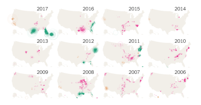
Over the past century, the US has witnessed a 20 percent increase in the amount of precipitation falling in the heaviest downpours.[34] There has also been a 40 percent increase in number of five-year rain events, extreme events that have only a 20 percent chance of occurring in any given year.[28]
Over the period from 1994-2008, extreme precipitation events linked to hurricanes accounted for more than 33 percent of the observed increase in heavy events across the US.[35] In the US southern climatic region (which extends from Mississippi through Texas) the number of daily heavy precipitation events has increased by 25 percent over the long-term average, and tropical cyclones contributed 48 percent of that increase.[35]
Since the 1950s, Houston has seen a 167 percent increase in the frequency of the most intense downpours.
 While there has been a recent increase in the number of landfalling US hurricanes, the increase in tropical cyclone-associated heavy events is much higher than would be expected from the pre-1994 association between the two, indicating that the upward trend in heavy precipitation events is due to an increase in the number of heavy precipitation events per system.
Much of the Gulf and Atlantic coastal areas have experienced an increase in the frequency of such events associated with tropical cyclones.[35]
Harvey intensified rapidly in the Gulf of Mexico, where waters were up to 2.7 - 7.2°F (1.5 - 4°C) above average
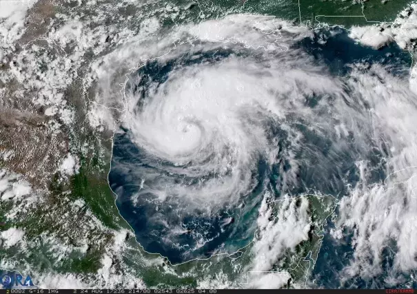
 Upon entering the warm waters of the Gulf of Mexico, Harvey intensified from a disorganized, fragmented system into a strong Tropical Storm, finally making landfall as a Category 4 hurricane around 9:45 pm on August 25 (with wind speeds of 130 mph).[15]
Harvey's rapid intensification from a tropical depression to an 85-mile-per-hour hurricane in less than 24 hours was due to favorable conditions—warm water and low wind shear[36]—in the Gulf of Mexico, where sea surface temperatures were up to 2.7 - 7.2°F (1.5 - 4°C) above the 1961-1990 average.[10]
On a global scale, ocean warming is largest near the surface.[37] Over the period 1971 to 2010, the upper 246 feet (75 meters) warmed by 0.20°F per decade. Across the four decades from 1971 to 2010, this sums to 0.8°F of sea surface warming.[38]
On August 25, Harvey passed over especially warm waters for more than 6 hours, and the extra energy allowed Harvey’s central pressure to fall 15 mb in just two hours, from 967 mb to 952 mb.[39]
Sea surface temperature has been consistently higher during the past three decades than at any other time since reliable observations began in 1880.[40]
Hurricanes are fueled by available heat. Warming seas are increasing the potential energy available to passing storms, effectively increasing the power ceiling or speed limit for these cyclones.[41] This trend is strongest in the Atlantic, where rising ocean temperatures correlate closely to an increase in Atlantic tropical cyclone strength.[42]
However, other factors, such as wind shear and the global pattern of regional sea surface temperatures, also play controlling roles. The balance of these factors is not fully known.[43]
Intense wind speed is only one of three major drivers of hurricane impacts, and Harvey has them all
A hurricane’s category is a measure of wind speed, but that is just one of the three major hazards caused by hurricanes, the other two being rainfall and storm surge. According to Texas State Climatologist John Nielsen-Gammon, hurricanes usually come with storm surge and either extreme winds or extreme rains.[44]
[Harvey] has the dual threat of both being very intense at landfall and producing widespread flooding at the same time." — John Nielsen-Gammon[44]
Hurricane Harvey had intense wind and rain because unique wind patterns prevented the storm from moving quickly out of the region.[44]
Climate change links to stalling weather systems
Rainfall totals were so high in the Houston area in large part because Harvey stalled over southeast Texas, where it was able to feed on warm waters in the Gulf of Mexico. Waves in the jet stream can stall in place (instead of moving eastward), leading to blocking and persistent weather patterns that fuel the intensity and duration of rainfall events.
A study from March 2017 found that climate change is altering large-scale weather patterns, such as the jet stream.[45] These changes can dramatically amplify extreme weather events, such as extreme rainfall, during the summer.[45]
The kind of stalled weather pattern that is drenching Houston is precisely the sort of pattern we expect because of climate change." — Michael Mann, climatologist and director of the Earth System Science Center at Pennsylvania State University[14]
I agree with Mike [Mann] that the weak steering currents over the south-central US coincident with Harvey are consistent with our expectations for a warmer world, which of course includes effects of a very warm Arctic." — Jennifer Francis, a climate scientist at Rutgers University and leading expert on climate change jet stream impacts[14]
A parallel study has tentatively documented a general slowdown of atmospheric summer circulation in the mid-latitudes.[46][47] This is a consequence of the disproportionally strong warming in the Arctic; it can make weather systems move less and stay longer in a given location – which can significantly enhance the impacts of rainfall extremes - and the study authors have pointed to Houston as an event fitting this pattern.[47]
Related Content