Headline
NASA's IMERG measures Hurricane Earl's deadly rainfall in Mexico
Mexico

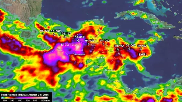
Earl's locations and intensities, as defined by the National Hurricane Center (NHC), are shown overlaid in white. Image: NASA/JAXA/Hal Pierce
Data from NASA's Integrated Multi-satellite Retrievals for GPM (IMERG) were used to estimate the amount of rain that fell from Aug. 2 through Aug. 8. GPM is the Global Precipitation Measurement mission, a joint mission of NASA and the Japan Aerospace Exploration Agency.
The analysis, created at NASA's Goddard Space Flight Center in Greenbelt, Maryland, showed rainfall over the period from when Earl became a tropical storm until Earl's remnants interacted with an area of disturbed weather along the Pacific coast. Some areas in extreme southern Mexico received up to 43.3 inches (1,100 mm) of rain
Related Content
Headline

Nov 28, 2016 | Category 6
Otto Shifts from Atlantic to Pacific after Historic Landfall in Central America
Headline

Nov 28, 2016 | The Weather Channel
Hurricane Otto Death Toll Rises to Double Digits
Headline

Nov 28, 2016 | Los Angeles Times via Associated Press
Hurricane Otto bears down on Central America unusually late in season
Headline

Nov 22, 2016 | The Weather Channel
Tropical Storm Otto Nears Hurricane Strength; Forecast to Make Very Rare Thanksgiving Hurricane Central America Landfall


