Bomb Cyclone March 2019
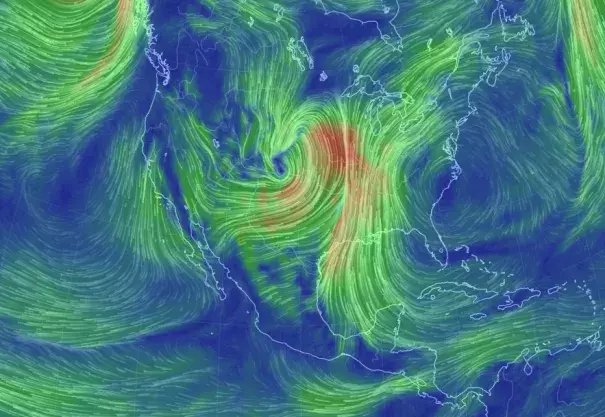
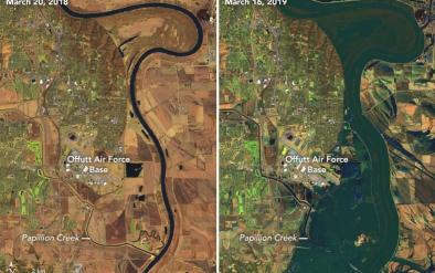
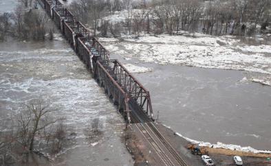
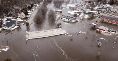
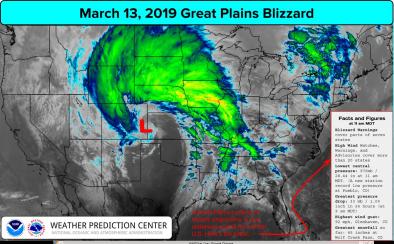
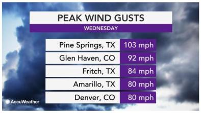
A major storm system intensified in the Central Plains, becoming one of the strongest on record for the region and bringing blizzard conditions, heavy precipitation and major flooding. Wind speeds up to 103 mph were recorded and several locations set all-time record low pressures.[1]
The National Weather Service's Weather Prediction Center has called this storm a 'cyclone of historic proportions.’[2]
The intensity of this storm is due to a merging of two powerful jet-stream disturbances that created a strong area of low pressure next to an area of high pressure that is feeding mild air and moisture from the Gulf of Mexico northward.[3] Climate change is linked to unusual jet stream behavior and warming in the Gulf of Mexico, both of which can affect storm activity. Climate change also affects many of the factors that can result in greater storm intensity.


Climate science at a glance
-
Disruption via Arctic warming affects weather patterns in the mid-latitudes such as the continental United States.
-
Global warming has now gone beyond adding energy to the thermodynamic dimension of our climate and is now affecting the patterns of atmospheric circulation, including the jet stream.
-
Warmer temperatures can supercharge storms. Warmer seas give up more moisture to the air above, and our warmer atmosphere is now holding more moisture
- Modeling studies consistently suggest that the frequency and intensity of severe storms in the United States could increase as climate changes, particularly over the U.S. Midwest and Southern Great Plains during spring.[1][2]
Background information
What is a bomb cyclone?
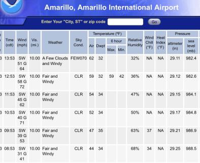
In the Northern Hemisphere, areas of low pressure are called cyclones, and rapidly developing storms are often called bombs or weather bombs. To qualify as a "bomb cylcone," an area of low pressure must drop at least 24 millibars (which measures atmospheric pressure) in 24 hours or less. This storm dropped 27 millibars and continues to strengthen.[3]
Other terms you may hear in meteorology when dealing with a storm like this include "explosive," "cyclogenesis," or "bombogenesis." Explosive refers to the rapid growth, and cyclogenesis means you have an area of low pressure that is gaining strength.
Where do bomb cyclones get their energy?
The primary energy driving a mid-latitude cyclone is the presence of contrasting air masses.[4] These storms most often occur from late fall to early spring when the temperature contrast between warm and cold air masses is greatest.
Climate signal #1: Arctic amplification
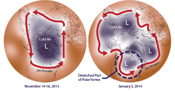 The jet stream is powered by the temperature difference between the Arctic and the mid-latitudes, and this difference is shrinking as the Arctic warms. Scientists suspect this may be making the jet stream slow down and meander, rather than speeding around the planet as it usually does.
Models report that cold weather Arctic invasions into the U.S. grow more intense in a warming world—a phenomenon of climate disruption sometimes popularly referred to as "global weirding."
Observations consistent with climate signal #1
- On March 13, the jet stream was very kinked over the U.S., with strong winds from two jet streams — the subtropical jet and polar jet streams — joining to create the storm.
- The polar jet was extremely wavy across the northern hemisphere, and is consistent with the unusual jet stream behavior expected due to Arctic warming.
Climate Signal #2: Sea surface temperature increase
The powerful merged jet streams driving the storms intensity are interacting with warmer conditions starting to build in the Northern Hemisphere. Warmer temperatures can supercharge storms. Warmer seas give up more moisture to the air above, and our warmer atmosphere is now holding more moisture.
Observations consistent with climate signal #2
- On March 10, sea surface temperatures over the Gulf of Mexico were up to 4°F above the average from 2003 to 2014.[5]
Climate Signal #3 and #4: Storm intensity increase and wind damage risk increase
Storm intensity is measured by the maximum surface wind speed or the minimum sea level pressure. The lower the pressure in a storm, the more intense it is. And the greater difference in pressure over an area, the stronger the winds.[6] Climate change affects many of the factors that can result in greater storm intensity. It leads to additional latent heat available in warmer air, and it can increase temperature gradients, which increases available potential energy.


