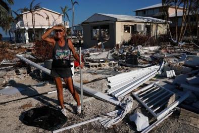
Hurricane Irma 2017
Overview
Climate change is amplifying the damage done by hurricanes, by elevating sea levels and thus extending the reach of storm surge, and by loading storms with additional rainfall and thereby increasing flood risk.
Climate change may also be driving the observed trend of increasing hurricane intensity[1] as well as the observed trend of more rapidly intensifying hurricanes.[2][3]
In addition there is significant evidence linking climate change to the observed shift in the track of hurricanes such as Irma toward the US coast.[4]
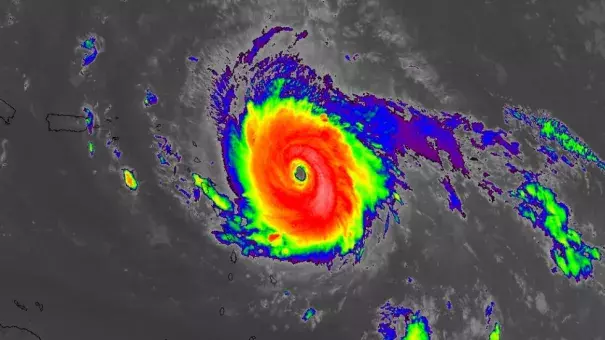
Hurricane Irma maintained maximum wind speeds of at least 180 mph for 37 hours, longer than any storm on Earth on record, passing Super Typhoon Haiyan, the previous record holder (24 hours).[5] Irma’s maximum accumulated energy over 24 hours was the highest for any Atlantic hurricane on record.[9] The storm intensified into a Category 5 with 185 mph winds on September 5, making it the most powerful Atlantic hurricane ever recorded outside of the Caribbean and Gulf of Mexico where warmer waters make those areas more prone to stronger cyclones.[6]
Hurricanes are fueled by available heat. As global warming heats sea surfaces, the energy available to power hurricanes increases, raising the limit for potential hurricane wind speed.[7]
Irma intensified in the Atlantic from September 4 to 5 as it entered a region of sea surface temperatures ranging from 0.9°F to 2.25°F (0.5°C to 1.25°C) above average, relative to a 1961-1990 baseline.[8]

Climate science at a glance
- Sea level rise has significantly extended the reach of storm surge and coastal flooding driven by hurricanes.
- Global warming is fueling extreme rainfall and increasing flood risk.
- Hurricanes have grown stronger over recent decades. There is a significant risk global warming may be driving that trend.[1]
- Hurricane Irma maintained maximum wind speeds of at least 180 mph for 37 hours, longer than any storm on Earth on record.[2]
- Increasing surface land and ocean temperatures are increasing the potential energy available to passing storms.[3]
- Irma intensified over sea surfaces that were 0.9°F to 2.25°F (0.5°C to 1.25°C) above average, relative to a 1961-1990 baseline.[4] (Note: This does not account for warming that occurred before the baseline period.)
- The record strength of Irma is consistent with observed trend of increasing hurricane intensity.
- Irma's rapid intensification is also consistent with the observed trend toward rapidly intensifying tropical cyclones, particularly in the North Atlantic and Caribbean.[5][6]
- Irma's track is consistent with the observed shift in the track of Cape Verde tropical cyclones, driven by human-caused climate change.
Climate change has significantly extended the reach of hurricane storm surge
The most important impact of tropical cyclones in coastal regions is storm surge.[7] Increases in storm surge related to climate change can be due to both rising seas and increasing storm wind speeds.[7]
Climate change has already contributed about 8 inches (0.19 meters) to global sea level rise,[8] and this has amplified the impact of cyclones by increasing baseline elevations for waves and storm surge.[8][9][10][11] A small vertical increase in sea level can translate into a very large increase in horizontal reach by storm surge depending upon local topography.
For example, sea level rise extended the reach of Hurricane Sandy by 27 square miles, affecting 83,000 additional individuals living in New Jersey and New York City[9] and adding over $2 billion in storm damage.[11] Aided by sea level rise, Hurricane Matthew set several storm tide records during its approach to the eastern sea board.
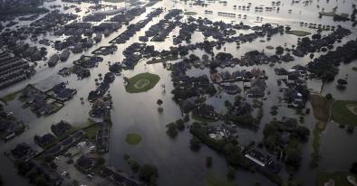
Elevated storm surge also combines with increased heavy precipitation to double the flooding risk imposed by climate change in what are known as compound flooding events along coastal areas in which rainfall run-off meets storm surge coming upriver.[12] Compound flooding affected both Jacksonville and Savannah during the passage of Irma.[13]
Global warming loads hurricanes with more rainfall, increasing the threat of flooding
As the global average temperature increases, so too does the ability of the atmosphere to hold and dump more water when it rains.[14] In addition, warmer sea surfaces evaporate more water vapor into the atmosphere. Atmospheric water vapor has been increasing.[15][16] And the observed increases have been studied and formally attributed global warming.[8][17][8]
As the amount of water in the air increases, precipitation increases from all types of storms, increasing flooding risk.[14]
Inland cities near large rivers in the US now experience more flooding, and this shift is consistent with climate change.[18]
Estimates of the impact of climate change have been calculated for individual hurricanes (Katrina and Ivan),[19] and an increase in rainfall rates is one of the more confident predictions of the effects of climate change on tropical cyclones.[7][20] Commenting on Hurricane Harvey, Kevin Trenberth, a senior scientist at the US National Center for Atmospheric Research, offered that the human contribution to the rainfall coming out of that storm could be up to 30 percent of the total.[21]
Over the past century, the US has witnessed a 20 percent increase in the amount of precipitation falling in the heaviest downpours.[22] There has also been a 40 percent increase in the number of five-year rain events, extreme events that have only a 20 percent chance of occurring in any given year.[18]
Over the period from 1994-2008, extreme precipitation events linked to hurricanes accounted for more than 33 percent of the observed increase in heavy events across the US.[23] The Southeast in particular saw a 40 percent increase in the amount of precipitation falling in the heaviest events, and 100 percent of this increase was linked to hurricane events.[23]
The increase in tropical cyclone-associated heavy events is much higher than would be expected from the pre-1994 association between the two, indicating that the upward trend in heavy precipitation events is due to an increase in the number of heavy precipitation events per system.[23] Much of the Gulf and Atlantic coastal areas have experienced an increase in the frequency of such events associated with tropical cyclones.[23]

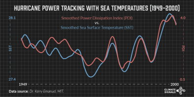
The warmer the waters, the more energy available to passing storms
Hurricane Irma has generated the most “accumulated cyclone energy,” a measure of a storm’s duration and intensity, of any Atlantic hurricane on record.[2] Atlantic hurricanes are getting stronger. Studies have found a 30-year trend showing an increase in Atlantic tropical cyclone strength alongside an increase in ocean temperatures over the Atlantic Ocean and elsewhere.[6][24] So far, the fingerprint of global warming in the intensity of tropical cyclones has been definitively identified in one ocean basin: the Northwest Pacific.[25]
[Hurricanes] extract heat energy from the ocean to convert it to the power of wind, and the warmer the ocean is, the stronger a hurricane can get . . . So, scientists are confident that as we continue to heat up the oceans, we’re going to see more of these high-end perfect storms.[26]
-- Jeff Masters, meteorologist and former hurricane hunter
Climate change also affects other factors that shape and control hurricane development, such as wind shear. In addition, hurricanes are powered by the difference between ocean temperature and the temperature at various levels in the atmosphere. It is the difference that matters,[27] not the absolute value of the sea surface temperature. The balance of all these factors is not fully known. However, hurricanes have grown stronger over recent decades. And there is a significant risk global warming may be driving that trend.
Irma certainly fits the pattern of increasingly strong hurricanes [which is] precisely what studies have predicted we would see as a result of human-caused warming.[26]
-- Michael Mann, a leading climatologist
A recent study on annual losses due to tropical cyclones in the United States found that $2 to $14 billion of the recorded annual losses in the active hurricane year of 2005 was consistent with the influence of climate change.[28] The study identified an upward trend in economic losses between 1900 and 2005 that cannot be explained by increases in commonly used socioeconomic variables.[28] The study identified an upward trend in both the number and intensity of hurricanes in the North Atlantic basin as well as in the number of loss-generating tropical cyclone records in the United States consistent with the rise in surface air temperature.[28]
Irma rapidly intensified over unusually warm water
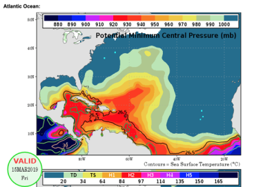
In just over 24 hours, from September 4 to 5, Irma intensified from a Category 2 hurricane with observed wind speed of 106 mph to a Category 5 hurricane with a maximum observed wind speed of 160 mph.[29] Irma continued to intensify on September 5 over unusually warm water, reaching wind speeds up to 185 mph. Irma's wind speeds were so high, they challenged the region's maximum estimated storm intensity,[30] an estimate based on current water temperature and other conditions.[31]
Irma also set an intensity record, as measured by windspeed. The storm maintained maximum wind speeds of at least 180 mph for 37 hours, longer than any storm on Earth on record, passing Super Typhoon Haiyan, the previous record holder (24 hours).[2]
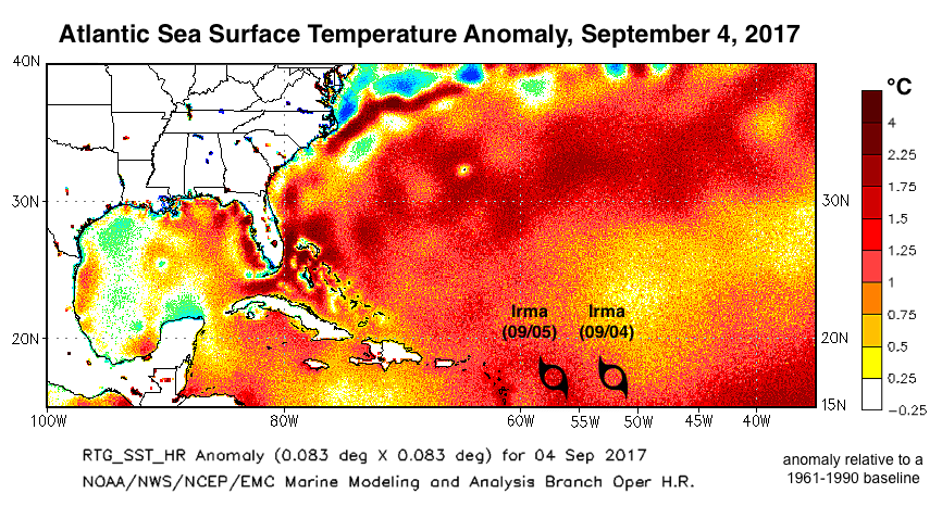 Irma grew in size amid nearly ideal circumstances for intensification[31], with low wind sheer and sea surface temperatures in the range of 0.9°F to 2.25°F (0.5°C to 1.25°C) above average, relative to a 1961-1990 baseline.[4] Sea surface temperatures were a very warm 29.5°C (85°F), and the total heat content of the ocean was a high, giving the storm plenty of heat energy to fuel intensification.[32]
Sea surface temperatures have been consistently higher during the past three decades than at any other time since reliable observations began in 1880.[33]
On a global scale, ocean warming is largest near the surface.[34] Over the period 1971 to 2010, the upper 246 feet (75 meters) warmed by 0.20°F per decade. Across the four decades from 1971 to 2010, this sums to 0.8°F of sea surface warming.[8]
Warming seas are increasing the potential energy available to passing storms, effectively increasing the power ceiling or speed limit for these cyclones.[7] This trend is strongest in the Atlantic, where rising ocean temperatures correlate closely to an increase in Atlantic tropical cyclone strength.[24]
However, other factors, such as wind shear and the global pattern of regional sea surface temperatures, also play controlling roles. The balance of these factors is not fully known.[35]

Major storms are spinning up faster
In the North Atlantic, storms have shaved almost a day (20 hours) off their spin-up to Category 3.[5] "Storms are intensifying at a much more rapid pace than they used to 25 years back,” reports the author of a 2012 study.[5] "They are getting stronger more quickly and also [to a] higher category. The intensity as well as the rate of intensity is increasing.”
The vast majority (79 percent) of major storms are rapid intensification storms, and the most intense storms are those that undergo rapid intensification according to a 2016 study.[36] These findings have been confirmed by a 2016 study which in turn linked the trend to warming seas.[37]
This trend toward more rapid intensification makes it much harder to predict and plan for the most intense storms.
Climate change driven hurricane migration
Globally, tropical cyclone activity has migrated poleward (northward in the northern hemisphere) over the last several decades, and this movement has been tentatively linked to the expansion of the tropical zone driven by global warming.[38]
In the Atlantic, a recent analysis extending back 450 years reports a clear shift in the track of Cape Verde tropical cyclones like Hurricane Irma.[39] Cape Verde hurricanes form in the low tropics, and are often the largest, most intense, and longest-lived storms of the season. The study found a north-eastward shift from the western Caribbean toward the North American east coast, driven largely by human-caused climate change since 1870.[39]
Irma’s track is consistent with this shift.
Related Content