2017 Arctic winter maximum and Antarctic summer minimum both set new record lows
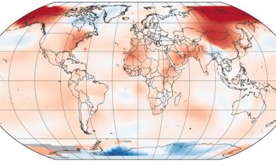
As spring dawns in the Arctic, autumn descends on the opposite pole. Arctic sea ice stretches to its winter maximum, and Antarctic sea ice shrinks to its summer minimum. Despite being at opposite points of their annual cycle, the Arctic and Antarctic had something in common in March 2017: record-low sea ice extents.
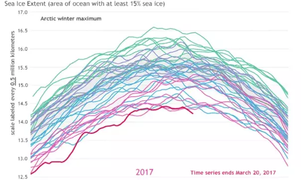
The animated gif (below) shows sea ice extent lines for January 1 through May 5 for every year in the continuous sea ice satellite record (1979–2017) for Arctic (top) and Antarctic (bottom). Yearly extents are color-coded by decade: 1979–1989 (green), 1990s (blue-purple), 2000s (blue), and 2010s (magenta). This animation is adapted from NSIDC’s Charctic interactive sea ice graph. Note that Arctic and Antarctic scales differ.

On March 22, the National Snow and Ice Data Center (NSIDC) announced record low sea ice seasonal extents for both hemispheres. Arctic sea ice extent reached its wintertime maximum on March 7, at 5.57 million square miles (14.42 million square kilometers). Antarctic sea ice extent reached its summertime minimum on March 3, at 813,000 square miles (2.11 million square kilometers). In both hemispheres, the extents were the lowest for the season in the 38-year satellite record.
Related Content