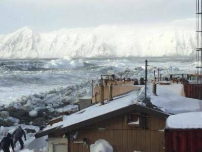
Arctic sea ice maximum at second lowest in the satellite record
Arctic sea ice appears to have reached its annual maximum extent on March 17. This is the second lowest Arctic maximum in the 39-year satellite record. The four lowest maximum extents in the satellite record have all occurred in the past four years. NSIDC will post a detailed analysis of the 2017 to 2018 winter sea ice conditions in our regular monthly post in early April.
Overview of conditions
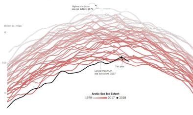
On March 17, 2018, Arctic sea ice likely reached its maximum extent for the year, at 14.48 million square kilometers (5.59 million square miles), the second lowest in the 39-year satellite record, falling just behind 2017. This year’s maximum extent is 1.16 million square kilometers (448,000 square miles) below the 1981 to 2010 average maximum of 15.64 million square kilometers (6.04 million square miles).
The four lowest seasonal maxima have all occurred during the last four years. The 2018 maximum is 60,000 square kilometers (23,200 square miles) above the record low maximum that occurred on March 7, 2017; 40,000 square kilometers (15,400 square miles) below the 2015 and 2016 maxima (now tied for third lowest); and is 190,000 square kilometers (73,400 square miles) below the 2011 maximum, which is now fourth lowest.
In March 2017, we reported a new record maximum being set, with 2016 sliding to the second lowest, and 2015 the third lowest. In November 2017, we updated our calculation of the monthly average sea ice extent in the NSIDC Sea Ice Index, resulting in 2016 tying with 2015.
The date of the maximum this year, March 17, was five days later than normal compared to the 1981 to 2010 median date of March 12.
...
The Antarctic minimum
As noted in our previous post, in the Southern Hemisphere, sea ice reached its minimum extent for the year on February 20 and 21, at 2.18 million square kilometers (842,000 square miles). This year’s minimum extent was the second lowest in the satellite record, 70,000 square kilometers (27,00 square miles) above the record low set on March 3, 2017. The Antarctic minimum extent is 670,000 square kilometers (259,000 square miles) below the 1981 to 2010 average minimum of 2.85 million square kilometers (1.10 million square miles).
Related Content