Headline
Arctic sea ice at minimum extent
Arctic
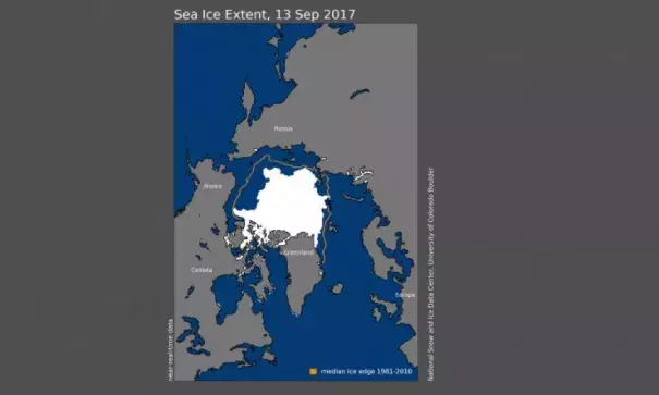
Arctic sea ice extent for September 13, 2017 was 4.64 million square kilometers (1.79 million square miles), the eighth lowest in the satellite record. The orange line shows the 1981 to 2010 average extent for that day. Image: National Snow and Ice Data Center
On September 13, 2017, sea ice extent reached an annual minimum of 4.64 million square kilometers (1.79 million square miles). This was 1.58 million square kilometers (610,000 square miles) below the 1981 to 2010 median extent for the same day, and 1.25 million square kilometers (483,000 square miles) and 500,000 square kilometers (193,000 square miles) above the 2012 and 2016 extents for the same day, respectively.
Related Content
Headline
Nov 29, 2017 | Mashable
Earth heads for a top 5 warmest year as the Arctic heats up
Science Source
| Wiley Interdisciplinary Reviews: Climate Change
Amplified Arctic warming and mid‐latitude weather: new perspectives on emerging connections
Francis, Jennifer A., Vavrus et al
Science Source
| The Arctic Monitoring and Assessment Programme (AMAP)
Snow, Water, Ice and Permafrost in the Arctic (SWIPA) 2017
Headline

Nov 28, 2017 | Carbon Brief
State of the climate: 2017 shaping up to be warmest ‘non-El Niño’ year
