Headline
Blizzard overview and why NYC got much more snow than forecast
United States
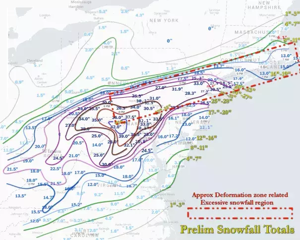
The general area where snowfall was significantly greater than originally forecast called for is outlined in the dashed line / rectangular box – and corresponds to the storm systems deformation zone.
Forecasts for the Super Blizzard of 2016 was one of the best examples of increasing model skill in recent years – with both the GFS and ECMWF calling for a major snow storm in the Mid-Atlantic region over a week ahead of time – and with little deviation in the forecast right up thru the event itself. But while the actual northern edge of the snow verified amazingly close to model forecasts, total snowfall in the northernmost sector of the storm turned out to be much greater than originally anticipated.
Related Content
Science Source
| Geophysical Research Letters
What would happen to Superstorm Sandy under the influence of a substantially warmer Atlantic Ocean?
Lau, William K. M., Shi et al
Science Source
| American Meteorological Society
Thermodynamic and Dynamic Mechanisms for Large-Scale Changes in the Hydrological Cycle in Response to Global Warming
Richard Seager, Naomi Naik, Gabriel A. Vecchi
Science Source
| Geophysical Research Letters
Dynamic and thermodynamic changes in mean and extreme precipitation under changed climate
Emori, S., Brown et al
Headline
Feb 5, 2016 | BBC News
US blizzard: Millions battle snow travel chaos - BBC News
