New Orleans Flood August 2017
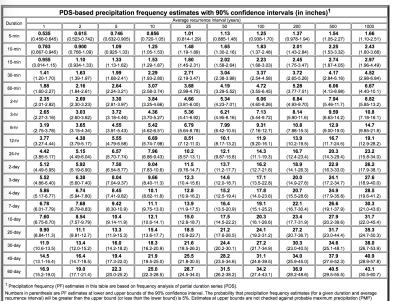
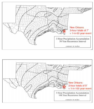
A very small, slow-moving storm pinpointed parts of New Orleans, Louisiana on August 5, dropping heavy rainfall that overwhelmed city pumps and helped to drive heavy flooding. Some neighborhoods witnessed as much as 8 inches of rainfall in the span of three hours[1], an extreme micro-burst expected to occur roughly every hundred years on average according to NOAA rainfall frequency tables and New Orleans city officials.[2][3]
Just two weeks prior the same areas endured extreme rainfall that mounted to as much as 4.5 inches in less than hour[4], a burst expected to occur roughly every fifty years[2]. New Orleans has seen a 62 percent increase in the number of heavy downpours since the 1950s.[5]
Increasing extreme rainfall is one of the clearest observed signals of climate change, and the fingerprint of global warming has been firmly identified in the global trend of increasing extreme precipitation. Back-to-back years of extreme August rainfall events are consistent with the global trend of increasingly frequent extreme and record-breaking rainfall events.
Climate science at a glance
- Climate change loads storms with more moisture, increasing the threat of flooding.[1][2]
- New Orleans has seen a 62 percent increase in the number of heavy downpours since the 1950s.[3]
- A larger percentage of precipitation in the US has come in the form of intense single-day events since the 1980s, and nine of the top 10 years for extreme one-day precipitation events have occurred since 1990.[4]
- Extreme events driven by natural variability and amplified by climate change are consistent with what climate science projects in a warming world.[5]
- Increasing extreme precipitation is an observed global trend firmly attributed to climate change.[6][7][8]
Extreme precipitation in New Orleans tests infrastructure and leads to widespread flooding
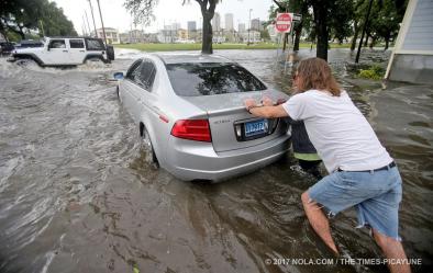
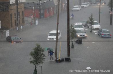
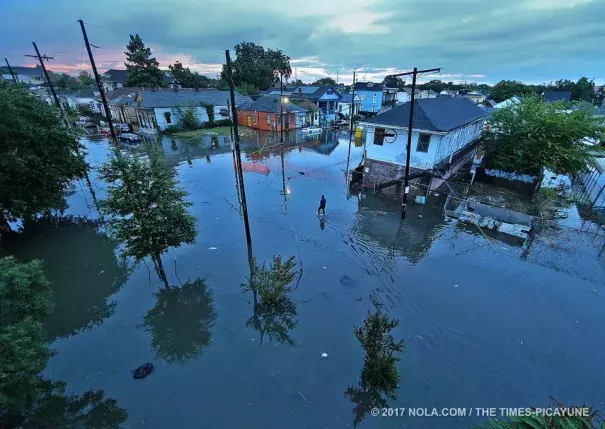
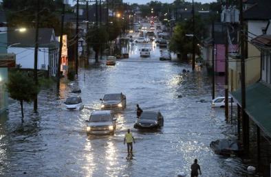
A small, slow moving thunderstorm dumped extreme rainfall amount over New Orleans on Saturday August 5. Some neighborhoods witnesses as much as 8 inches of rain in just three hours.[9] Such high 3-hour rainfall totals in the region are expected to occur roughly once every 100 years, according to NOAA rainfall frequency tables.[10] In just over two hours, around 5.4 inches of rain was recorded in the downtown New Orleans area, the National Weather Service estimated.[11] 2-hour rainfall rates of this magnitude are expected to occur only once every 50 years.[10]
Just two weeks prior the same areas endured extreme rainfall totals of 4.5 inches in less than an hour, a burst expected to occur only once every 50 years.[10]
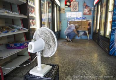
During both flood events, city officials said the extreme rainfall rates were too much for the Sewerage and Water Board’s 24 pump stations to handle.[12][13] The flooding was also worsened during the August 5th event in two New Orleans neighborhoods hit hardest by pumping stations that were operating at barely above half their full capacity.[14]
There is no drainage system in the world that can handle that immediately. I continue to tell the people what this system can do. It’s pretty amazing in that it can do one inch of rain in the first hour and a half an inch of rain every hour after that. We are dealing with 8 to 10 inches of rain in three hours. It is not going to be able to pump that in an hour.
Cedric Grant, Executive Director of the Sewerage & Water Board[12]
The heavy rains caused water levels to rise over a foot on streets throughout the city, swamping numerous vehicles and businesses.[11]
I've never seen it this bad," said a woman clutching an umbrella and trudging through knee-deep water on St. Peter Street near Rampart. "That was a lot of rain coming down quick."[11]
Global warming increases the air's water-holding capacity
Global warming increases the rate at which ocean water evaporates into the air. It also increases the amount of water vapor the air can hold when fully saturated. As the amount of water in the air increases, this causes more precipitation from all storms, which significantly amplifies extreme precipitation and flooding risk.[2]
The average moisture content of the atmosphere has increased by about 4 percent since the 1970s.[15] This impact is magnified by the fact that storms reach out and gather water vapor over regions that are 10 to 25 times as large as the precipitation area, thus multiplying the effect of increased atmospheric moisture.[16]
About 18 percent of the "moderate" (i.e. 1-in-3 year) daily precipitation extremes over land are attributable to warming, while a much larger share of very extreme events is attributed to warming.[6]
More frequent extreme precipitation events are consistent with observed climate change trends
 The August 2017 storm brought up to 8 inches in three hours to New Orleans. Two weeks prior, the same areas received 4.5 inches in less than an hour.
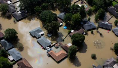
And one year prior, in August 2016, a 1-in-1000 year rain event dumped over two feet of rain in five Louisiana cities near Baton Rouge, to the north of New Orleans, over the course of 48 hours.
These back-to-back extreme rainfall events are consistent with observational data showing that extreme precipitation events are increasing in frequency.
Since the 1950s, New Orleans has seen a 62 percent increase in the number of heavy downpours.[3]
Over the past century, the US as a whole has witnessed a 20 percent increase in the amount of precipitation falling in the heaviest downpours, which has dramatically increased the risk of flooding.[5][17] Since the 1980s, a larger percentage of precipitation has come in the form of intense single-day events, and nine of the top 10 years for extreme one-day precipitation events have occurred since 1990.[4]
In the Southeastern US, extreme precipitation has increased 27 percent from 1958 to 2012. Significantly, the US National Assessment reports that the long-term trend in the Southeast is larger than natural variation, an indication that changes brought on by global warming are overwhelming natural variation even at the regional level in the Southeast.[5]
Changes in Louisiana average precipitation amount are uncertain
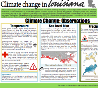
In addition to more rain arriving in heavy downpours, annual rainfall in Louisiana has increased by 20 to 30 percent in the past 100 years.[18] This is consistent with the general physics indicating that as average temperatures at the Earth’s surface rise, more evaporation occurs, which, in turn, increases overall precipitation.
However, Louisiana is located in a transition zone between drier conditions (to the south) and wetter conditions (to the north). [NCA, Chapter 2] As the transition zone shifts northward due to global warming in decades to come, Louisiana can expect to see a decrease in annual mean precipitation. [NCA, Chapter 2]
The latest US National Climate Assessment (2013) confirms that precipitation decreases are likely to occur in most of southeast USA (including Louisiana) in all but the fall season, though precipitation over the US, as a whole, will increase.[5][19]
In general, while significant trends in average precipitation have been detected, the fraction of these trends attributable to human activity is difficult to quantify at regional scales because the range of natural variability in precipitation is large. [NCA, Chapter 2]
The main takeaway is that the primary climate change signal related to precipitation is the increased frequency of heavy precipitation events.
This is reinforced by observations showing that changes in the frequency of extreme precipitation events are outpacing changes mean precipitation.[20] This reflects a change in the tails of the distribution, which now include more extreme events.[20]
Related Content