Northeast Blizzard March 2017
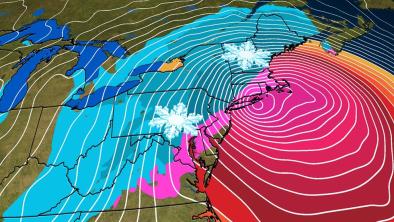
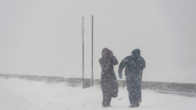
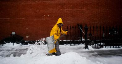
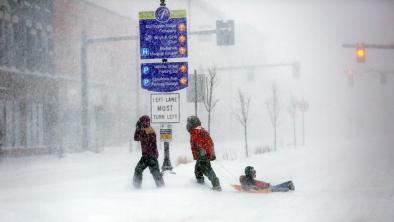
Winter Storm Stella hit the Northeastern United States beginning late on Monday, March 13, bringing up to 42 inches of snow,[1] snowfall rates up to 7 inches in one hour,[1] hurricane force winds,[2] and coastal flooding.[3] The snowstorm was a classic nor'easter but has multiple climate connections that helped to amplify its impact.
Elevated sea levels may have amplified and extended the reach of Stella's storm surge. A warmer atmosphere can hold more water vapor when saturated, increasing blizzard risk as storms like Stella can collect and dump that moisture as extreme snowfall, sleet and rainfall. Before the storm, sea surface temperatures were record warm in the Atlantic Gulf Stream, pumping more heat energy and moisture into the storm, further increasing the risk of blizzard.
The amplification of these physical mechanisms can be seen in the long-term trends. Between 1961 and 2010, there have been twice as many extreme regional snowstorms in the US compared to 1900 to 1960. In New York City, 6 of the 10 all-time biggest snowstorms on record have occurred since 2000. An extreme event driven by natural variability and amplified by climate change is consistent with what science projects for a warming world.


Climate science at-a-glance
- Stella was driven by classic Nor’easter conditions, aided by other regional weather patterns, and amplified by climate change. This combination is consistent with what science projects for a warming world over the short-term.
- Extreme winter snowfall is increasing in many colder regions as the warming atmosphere is holding more water vapor when saturated and dumping more snowfall where temperatures are still below freezing.
- The storm pulled moisture from the Gulf Stream where sea surface temperatures were record warm, increasing the risk of blizzard. Snowfall and sleet can increase where temperatures are still below freezing while rain can increase where temperatures rise above freezing. The profile of Stella matches the Goldilocks profiles of recent nor'easters in which a sharp contrast between cold continental air and a relatively warm ocean permitted the storms to tap moisture fed by high sea surface temperatures and convert it into exceptional snowfall.
- There have been twice as many extreme regional snowstorms in the US between 1961 and 2010 compared to 1900 to 1960.[1]
- In New York City's Central Park, of top 10 all-time snowfall events since 1869, 6 have occurred since 2000.[2]
- Coastal flooding driven by storms is now significantly worse due to storm surge riding on higher sea levels.
Warmer seas helped to fuel Winter Storm Stella's destructive power
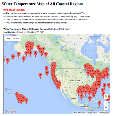
Winter Storm Stella pulled heat and moisture from the Gulf Stream, where sea surface temperatures were record warm at more than 7.2°F (4°C) above the 1961 to 1990 average.[3][4] Global warming raises sea surface temperatures.
The additional water vapor fed into the storm can increase snowfall where temperatures are still below freezing and increase rain and sleet where temperatures rise above freezing. The water vapor can also provide additional latent heat to power the storm. This can help fuel hurricane-force winds that have the potential to whip up dangerous storm surge.[3][4]
Warmer, saturated air holds and dumps more snow giving rise to more extreme storms
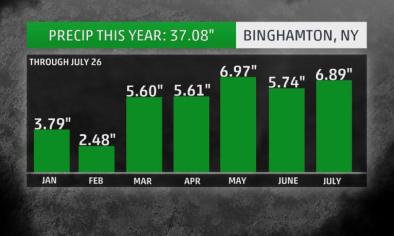
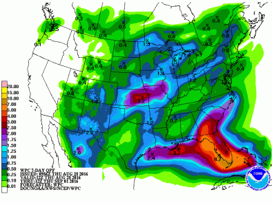
Widespread 1- to 3-foot snow accumulations were observed in the Northeast, led by 42 inches in West Winfield, New York.[5] An incredible snowfall rate of 7 inches in one hour was reported in Ilion, New York, Tuesday afternoon.[5] Burlington, Vermont, reported 5 inches of snow in one hour Tuesday afternoon.[5] Stella was the heaviest snowstorm on record in Binghamton, New York, surpassing Winter Storm Argos in November.[5] As of 8 pm on the evening of March 14, 28.8 inches of snow had been measured at Binghamton Regional Airport.[5]
Extreme precipitation is linked to the global warming of the atmosphere. A warmer atmosphere that is fully saturated holds and dumps more precipitation. Storms passing through a warmer atmosphere can pick up more moisture, resulting in extreme precipitation: such as blizzard when temperatures are below freezing, and sleet or heavy rain when they are not.[6]
Temperatures in the Goldilocks range of between about 28°F and 32°F, accompanied by moisture, mean more snow. The profile of Stella matched the Goldilocks profiles of recent nor'easters in which a sharp contrast between cold continental air and a relatively warm ocean permitted the storms to tap moisture fed by high sea surface temperatures and convert it into exceptional snowfall.[6]
The amplification of these physical mechanisms can be seen in the long-term trends. There were twice as many extreme regional snowstorms in the US between 1961 and 2010, compared to 1900 to 1960.[1] In New York City, 6 of the top 10 snowfall events since 1869 for Central Park have occurred since 2000.[2]
These events and trends are in-line with a consistent set of findings delivered by numerous leading science reports. The US National Climate Assessment reports that there has already been an increase in extreme precipitation in the Northeast, with precipitation rising by 71 percent between 1958 to 2012.[7] Extremely heavy snowstorms have increased in number during the last century in northern and eastern parts of the United States.[7]
Should global warming continue unabated, local temperatures in the US northeast would eventually warm to the point of converting extreme snow fall to extreme rainfall. However, that signal has not yet been detected and is not expected to emerge for perhaps another 20 years.[8]
Climate change contribution to sea level rise can top coastal defenses
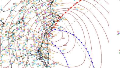
The storm had exceptionally strong winds, with one location on Cape Code recording a hurricane force wind gust of 79 mph.[9] The strong winds helped raise coastal waters along much of the coast of Delaware, New Jersey, New York, Connecticut, and Massachusetts, including Cape Cod and the islands.[10]
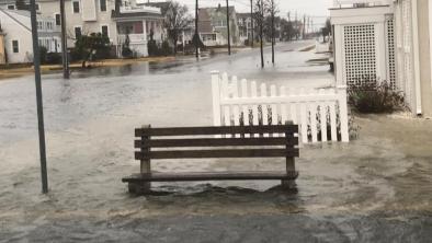
In New Jersey, Stone Harbor (picture right) and Atlantic City reported flooding along city streets on March 14 as the tide rose in the hour leading up to high tide, and beaches eroded in North Wildwood.[11] In Atlantic City, the tide level reached as high as 7.8 feet, just shy of the 7.84-foot high tide reported during Winter Storm Jonas in January 2016 and major flood stage, which is 8 feet.[11]
Coastal flooding driven by storms is amplified by storm surge riding on higher sea levels. Due to climate change, the global ocean has already risen eight to ten inches over the last century as warmer ocean waters expand and ice sheets and glaciers melt. In addition, the intense winds that produce storm surge can gain strength from warmer than average sea surface temperatures. Warming seas and elevated sea levels are both driven by global warming.
In low-lying areas, a small increase in sea levels translates into much greater inundation as storm surge travels much further inland. In addition, even a small increase in surge can top coastal defenses, and disaster often strikes when thresholds are crossed. 24 percent of the property damage in New York City during Superstorm Sandy has been attributed to elevated sea levels that extended the reach of the storm's surge.[12] While climate change may be responsible for only part of any particular climate event, that change may be largely responsible for most of the damage in that event, such as when flooding defenses are breached.
New, more intense extremes can overwhelm and collapse existing human systems and structures.[13]
Related Content