How steamy Great Lakes waters will amplify lake-effect snowstorm
The warmer than normal waters of the Great Lakes are going to have a couple of effects on the coming lake effect snow situation.
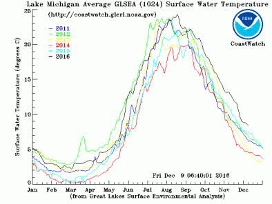
The Great Lakes surface water temperatures are still warmer at this time than they have been in recent years. The water is warmer than the historical normal, due to the warm fall and warm November.
First, the warm water will enhance the lake effect process. Lake effect snow is produced by rising currents of air in an unstable atmosphere. We usually think of instability during summer severe weather outbreaks. But the warm water lying underneath cold air aloft also makes the air unstable. Warm air is light, and cold air is heavy. In the lake effect situation, the warm air at the surface wants to rise to higher heights and the cold air wants to sink to the ground.
The warmer the water is, the faster the air will rise and the lake effect process will be heavier.
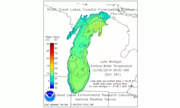
Currently Lake Michigan is listed as having a lake-wide surface water temperature of 47.5deg.
Lake Superior is also still fairly warm for this time of year.
The Great Lakes Environmental Research Laboratory lists Lake Superior as having an average surface water temperature of 43.4deg. That may sound too cold to swim in, but it's warm for lake effect snow.
So the relatively warm waters will fuel heavy lake effect snow.
...
A more subtle, but important influence of the warm water is an effect on the surface wind direction. As the cold air crosses Lake Michigan, an elongated low pressure system forms down the length of Lake Michigan.
This low pressure system "bends" the wind to a more southwesterly direction, as compared to what's expected. Computer models are sophisticated enough now to forecast this situation.
What is does for a forecast is possibly keeps the wind more southwesterly and blows lake effect snow bands into unexpected areas. Most of the snow forecast is currently based on an eventual northwest wind. If the lake-induced low pressure system forms, heavier lake effect could creep into Grand Rapids and Muskegon, and out of Kalamazoo. This would be due to a more southwesterly wind.
Related Content