Hurricane Matthew Recap: Destruction From the Caribbean to the United States
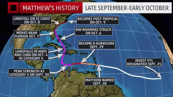
Once Matthew reached the eastern Caribbean, it became a hurricane and rapidly intensified. Its peak intensity was late Sept. 30 into early Oct. 1 when it reached Category 5 strength with 160 mph winds.
Matthew then made landfall in Haiti and eastern Cuba on Oct. 4 as a Category 4.
From there, Matthew hammered the Bahamas Oct. 5-6 as a Category 3 and 4 hurricane.
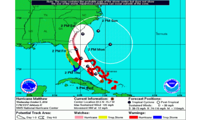
The southeastern United States was then hit hard by Hurricane Matthew as it moved very close to the coasts of Florida, Georgia, South Carolina and North Carolina. Matthew made one official U.S. landfall on Oct. 8 southeast of McClellanville, South Carolina, as a Category 1 hurricane with 75 mph winds.
Matthew was declared post-tropical by the National Hurricane Center as it moved away from North Carolina on Oct. 9.
...
Matthew's U.S. Storm Reports
Storm Surge
On Oct. 7 in Florida, a peak surge of 9.88 feet above normal was measured at an NOS tide gauge at Fernandina Beach, Florida.
Storm surge flooding affected the St. Augustine area, including major flooding on Anastasia Island where water was reported to be 2.5 feet above ground level. To the south in nearby Flagler Beach, Florida, parts of A1A were washed out by the storm surge.
The NWS-Jacksonville conducted a storm survey and found a new inlet was carved between Marineland and Matanzas Inlet, between Palm Coast and St. Augustine Beach, Florida.
The St. Johns River in northeast Florida reached its highest level on record at Shands Bridge, along with 3 to 4.3 feet of storm surge inundation reported at the Racy Point, Red Bay Point and I-295 bridge tide gauges. Early in the morning on Oct. 8, the St. Johns River was flowing backwards.
Matthew's storm surge coupled with high tide lead to a record tide level at Ft. Pulaski, Georgia, early Oct. 8, and storm surge inundation roughly waist-deep was reported in parts of Charleston, South Carolina.
A storm surge of just under 8 feet was recorded at Ft. Pulaski, Georgia, between Savannah and Tybee Island, according to NOAA/National Ocean Service data. Fort Pulaski set a new record tide level of 12.57 ft MLLW (above normal low tide), which occurred two hours after high tide. This beats the old record going back to Hurricane David in 1979.
Tide levels at the Charleston Harbor peaked at their third highest level on record with the morning high tide on Oct. 8, the highest levels, there, since Hurricane Hugo in 1989 and over a foot higher than the early October 2015 flood event. Water was entering homes on West Ashley in Charleston, according to the National Weather Service.
On the afternoon of Oct. 8, water levels were topping 5 feet above normal at Oyster Landing, near Georgetown, South Carolina, and at Myrtle Beach. In southern North Carolina, water levels on the Cape Fear River at Wilmington shattered a record from Hurricane Hazel in 1954.
The Springmaid Pier in Myrtle Beach was heavily damaged, a section of the Oak Island (North Carolina) pier was also also damaged by waves, and the Jacksonville Beach pier was also damaged.
On the morning of Oct. 9, major sound side storm surge flooding affected the Outer Banks of North Carolina.
Wind Reports
Here are some of the top wind gust reports from Matthew:
- Cape Canaveral, Florida: 107 mph (on an elevated tower at 54 feet above the ground)
- Tybee Island, Georgia: 96 mph
- Jennette's Pier, North Carolina (Outer Banks): 91 mph
- Daytona Beach, Florida: 91 mph
- Hilton Head Island, South Carolina: 88 mph
- Jacksonville Area: 87 mph
- South Ponte Vedra Beach, Florida: 84 mph
- Duck, North Carolina: 83 mph
- Beaufort, South Carolina: 83 mph
- Fort Pulaski, Georgia: 79 mph
- Folly Beach, South Carolina: 76 mph
- Oceana NAS, Virginia: 75 mph
- Myrtle Beach, South Carolina: 74 mph
- Savannah, Georgia: 71 mph
- Melbourne, Florida: 70 mph
- Charleston, South Carolina: 69 mph
- Florence, South Carolina: 67 mph
- Lumbertgon, North Carolina: 66 mph
- Fayetteville, North Carolina: 62 mph
- Sumter, South Carolina: 61 mph
- Orlando Area: Gusts over 60 mph
Interestingly, some of the strongest wind gusts in the Carolinas occurred after the center of Matthew passed by.
Rainfall Reports
Fayetteville, North Carolina, picked up over 8 inches of rain in 6 hours on the morning of Oct. 8 and totaled over 14 inches of rain from this event. As you would expect, major flooding materialized.
The NWS office in Wilmington, North Carolina, issued its first ever flash flood emergency early Oct. 8 for Horry County, including the Myrtle Beach Grand Strand and Conway, South Carolina, due to the combination of rainfall and storm surge flooding. Flash flood emergencies are only issued during rare, exceptionally dangerous events.
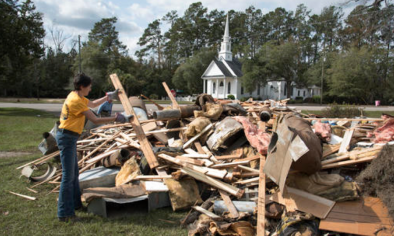
Matthew brought widespread flash flooding and record river flooding to eastern North Carolina where hourly rainfall estimates from radar were as high as 7 inches per hour. Buildings were flooded, roads washed out, and sections of Interstates 95 and 40 were flooded in the Tar Heel State.
Here are some of the rainfall totals from Matthew, according to NOAA's Weather Prediction Center:
- Savannah (Hunter U.S. Army Airfield), Georgia: 17.49 inches
- William O Huske Lock 3, North Carolina: 15.65 inches
- Goldsboro, North Carolina: 15.24 inches
- Fayetteville, North Carolina: 14.82 inches
- Beaufort, South Carolina: 14.04 inches
- Reevesville, South Carolina: 12.90 inches
- Virginia Beach, Virginia area: 12.16 inches
- Suffolk, Virginia: 11.24 inches
- Hilton Head Island, South Carolina: 11.00 inches
- Charleston, South Carolina: 10.48 inches
- Folly Field, South Carolina: 9.82 inches
- Orlando, Florida (Sanford): 8.99 inches
- Jacksonville, Florida: 6.75 inches
- N. Myrtle Beach, South Carolina: 5.67 inches
- Daytona Beach, Florida: 5.29 inches
Savannah International Airport had their second wettest calendar-day rain on record dating to 1871 on October 7.
Among the notable rainfall flooding reports, included:
- Johnston County, North Carolina: Multiple water rescues; people trapped in homes, on top of vehicles
- Fayetteville, North Carolina: I-95 flooded
- Near Coats Crossroads, North Carolina: Six-mile stretch of Interstate 40 closed
- Raleigh, North Carolina: Several feet of water on Atlantic Avenue and Hodges Street
- Near Clarkton, North Carolina: Vehicle swept away in road washout; 2 killed
- Guilford, Halifax, Harnett, Nash, Sampson, Wayne Counties, North Carolina: Numerous roads flooded and closed.
- Sellers, South Carolina: Cars, homes, town hall flooded
- Holly Hill, South Carolina: Water up to 3 feet deep flooded buildings.
- Near Cameron, South Carolina: Road washed out
- Columbia, South Carolina: Numerous roads closed due to flooding, downed powerlines, trees
- College Park, South Carolina: Water entering some homes
Caribbean and Bahamas Storm Reports, Recap
On the day Matthew was named (Sept. 28), George F.L. Charles Airport on St. Lucia picked up 9.21 inches of rain.
On the south side of the island, Hewanorra Int'l Airport picked up 13.19 inches of rain in just 12 hours from 8 p.m. Sept. 28 through 8 a.m. Sept. 29, according to the Antigua Met Service.
A wind gust to 89 mph was reported in St. Pierre, Martinique, Sept. 28. Sustained winds of 39 mph were reported on the island of Barbados.
Matthew strengthened to a rare Category 5 late Sept. 30, becoming the first Category 5 Atlantic basin hurricane since Hurricane Felix in early September 2007.
According to Colorado State University tropical scientist Dr. Phil Klotzbach, Matthew became the lowest latitude Category 5 hurricane in the Atlantic on record (beating the old record set by Ivan in 2004).
Some outer rainbands triggered flash flooding in Jamaica Oct. 2, hundreds of miles away from the center of Matthew.
Hurricane Matthew's eye first came ashore in the Greater Antilles in the western Tiburon Peninsula of Haiti near the town of Les Anglais around 7 a.m. EDT Oct. 4, according to the National Hurricane Center.
Matthew was the first Category 4 Haiti landfall since Hurricane Cleo in 1964, and only the fourth such intensity or stronger hurricane to track within 65 nautical miles of southern Haiti's Tiburon Peninsula since the 1960s, according to NOAA's Best Tracks Database.
Hurricane Matthew made a second landfall near Juaco, Cuba, around 8 p.m. EDT Oct. 4. An unconfirmed wind gusts to 155 mph was reported in the town of Baracoa, Cuba, in Matthew's eyewall.
After moving away from Cuba, Matthew passed through the Bahamas.
Late Oct. 5, a 119 mph sustained wind was clocked at Exuma International Airport. Sustained winds over 100 mph were also clocked at George Town, also on Exuma.
Winds gusted to 85 mph in Nassau on Oct. 6 as Matthew moved through.
Radar indicates that Matthew made landfall along the western tip of Grand Bahama Island prior to 8 p.m. EDT on Oct. 6 with extremely high winds battering that island in the eyewall.
In the 9 p.m. hour on Oct. 6, Grand Bahama reported a sustained wind of 64 mph. Freeport in the northwest Bahamas reported sustained winds of 100 mph with gusts up to 121 mph as the northern eyewall lashed the area.
Settlement Point reported sustained winds of 79 mph and gusts as high as 105 mph.
Related Content