January Thaw in Sight after Two-Week Wintry Onslaught and “Bomb Cyclone” by Bob Henson
Thursday’s storm, dubbed Grayson by The Weather Channel, will go down in meteorological annals as one of the strongest and most rapidly intensifying midlatitude cyclones on record for the waters off the East Coast. Preliminary analyses from NOAA/NWS Weather Prediction Center showed that Grayson deepened by an incredible 59 millibars in just 24 hours, which would be a record for midlatitude storms in this part of the Northwest Atlantic. The storm plowed directly into Canada’s Maritime Provinces, where the New Brunswick city of Saint John recorded a surface pressure of 951.1 mb—its lowest reading at any point in records going back to 1953.
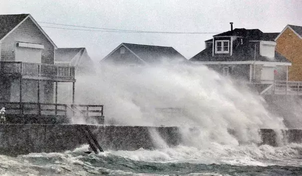
Grayson deposited a foot or more of snow from the Hampton Roads area of VA/NC to southeast New England, much of it in very short order. In central Long Island, New York, Islip got five hours of snowfall at rates of 2”-3” per hour. At least eight deaths have been associated with Grayson, according to weather.com. The storm’s intense deepening led to very high winds, especially along the immediate coast and offshore. Gusts reached 76 mph at Nantucket, MA, and 106 mphin northern Nova Scotia. Halifax, NS, experienced a record-strong January gust of 122 km/hr (75.8 mph). Wave heights reached up to 56 feet south of Nova Scotia, according to The Weather Network.
Related Content

