Katrina's Surge
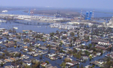
A Weather Underground 16 part series about Hurricane Katrina, by Margie Kieper. Hurricane Katrina of 2005 produced the highest storm surge ever recorded on the U.S. coast—an astonishing 27.8 feet at Pass Christian, Mississippi.
This bested the previous U.S. record of 22.8 feet, which also occurred at Pass Christian, during 1969's Hurricane Camille. According to the NHC Katrina final report, Hurricane Katrina brought a surge of 24 - 28 feet to a 20-mile stretch of Mississippi coast. Fully 90 miles of coast from eastern Louisiana to Alabama received a storm surge characteristic of a Category 3 hurricane. The colossal damage that resulted has been documented by blogger Margie Kieper during a series of blog posts that ran in the summer of 2006. The contents are reproduced here, and consist of an introduction explaining why the surge was so large, and 16 parts exploring the damage done to each stretch of the Gulf Coast ravaged by Hurricane Katrina in 2005
Related Content