Records fall like sweat as heat wave continues grip on N.J.

As the fifth heat wave of the summer continues to roll on across New Jersey, temperature records are getting shattered.
During the weekend — the hottest phase of the current heat wave — the mercury soared to the upper 90s and close to triple digits in more than a dozen towns, setting new daily temperature records in Atlantic City, Cape May, Hightstown and Millville, according to climate data from the National Weather Service.
• Atlantic City set a new record for Aug. 13 and Aug. 14, with temperatures climbing to 97 and 98 on those days. The previous records were in place since 2005 and 1985.
• Cape May set a new record for Aug. 13 and Aug. 14, with temperatures climbing to 95 and 99 on those days. The old records dated back to 1949 and 1926.
• Hightstown set a new record for Aug. 13 and Aug. 14, with temperatures climbing to 96 and 99 on those days. The previous records were set in 2002 for both days.
• Millville set a new record for Aug. 14, with the temperature hitting 97 degrees on Sunday. The old mark was set in 1988.
The hottest spot across the state may have been Harrison in Hudson County, where the mercury climbed to 100 degrees on Saturday afternoon, according to New Jersey State Climatologist David Robinson at Rutgers University.
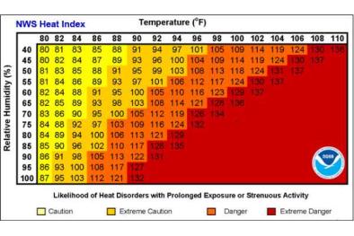
Making the conditions worse outside, the heat index — how hot it feels when the air temperature is combined with the humidity — rose to an unbearable 110 to 115 degrees in parts of the Garden State. On Saturday, the heat index hit 115 degrees at Joint Base McGuire-Dix-Lakehurst, 113 degrees in Millville, 112 in Wildwood and 111 in Atlantic City, said Walter Drag, a meteorologist at the National Weather Service's regional forecast office in Mount Holly
Related Content