Headline
Severe thunderstorm warning, tornado watch issued for Charleston area, National Weather Service says
United States
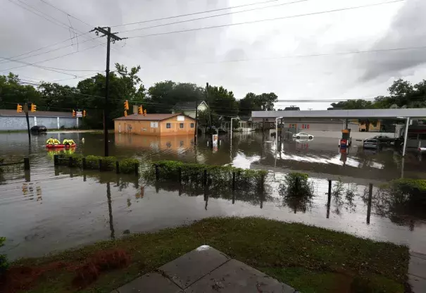
Rescue crews cross through the intersection of King St. and Huger St. after heavy rain on Tuesday, May 23, 2017. Photo: Michael Pronzato
As of 5:20 p.m., radar rainfall estimates showed between 1.5 inches and 2.5 inches of rain fell across the greater Charleston area since 2 p.m., the Weather Service said.
"The previous heavy rainfall resulted in multiple flooded roads and a couple of water rescues," the Weather Service said. "Based on latest reports, several roads remain closed due to lingering flood waters. Through 7 p.m., showers and thunderstorms will result in rounds of moderate rainfall."
...
"The arrival of the heavy downpours will overlap with this evening's high tide, resulting in significant street flooding and building flooding," the Weather Service said. "Many roads will be impassable."
Related Content
Science Source
| Proceedings of the National Academy of Sciences
Human influence has intensified extreme precipitation in North America
Megan C. Kirchmeier-Young and Xuebin Zhang
Science Source
| Science Advances
Unprecedented climate events: Historical changes, aspirational targets, and national commitments
Noah S. Diffenbaugh, Deepti Singh, and Justin S. Mankin
Science Source
| American Meteorological Society
Precipitation Extremes: Trends and Relationships with Average Precipitation and Precipitable Water in the Contiguous United States
Kenneth E. Kunkel, Thomas R. Karl, Michael F. Squires et al
Science Source
| Nature Communications
Social inequalities in climate change-attributed impacts of Hurricane Harvey
Kevin T. Smiley, Ilan Noy, Michael F. Wehner et al
