In some places, experimental NOAA models could have predicted Western snow drought eight months in advance
In the western United States, residents rely on winter’s snow for summer’s water. A string of skimpy snowpacks between 2012 and 2015 in many Western mountain ranges curtailed municipal water use, threatened endangered species, dried out crops and rangeland, and boosted the risk of wildfire. Better snowpack forecasts might have helped the West prepare for what was coming, but seasonal snowpack is notoriously difficult to predict.
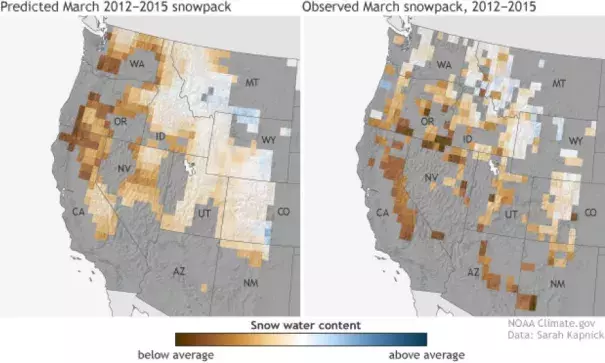
A recent “hindcast” experiment led by Sarah Kapnick of NOAA’s Geophysical Fluid Dynamics Laboratory shows climate experts are making progress, though. This pair of maps shows average March snowpack between 2012-2015: predictions made on July 1 of each year (left) compared to observations (right). The maps show snow water equivalent: the amount of liquid water a snowpack would yield if it were all to melt at once. Places where the water content of the snowpack was above average are blue; places where it was below average are brown.
The maps show that the predictions from the experiment’s 50-kilometer resolution model matched many of the regional features of the 2012-2015 snow drought, especially the southwest-northeast gradient: below-average snowpack in the west-southwest (Oregon’s Cascade Range, the Sierra Nevada of northern California, Utah’s Wasatch Range) and above-average snowpack in small areas of the Northern Rockies in Montana and Wyoming.
