Why the Tropical Atlantic Ocean Is Different from This Time Last Year, and What It Could Mean for Hurricane Season
Water temperatures across the ocean's surface in the tropical Atlantic Ocean this spring could be offering a hint for what to expect this hurricane season.
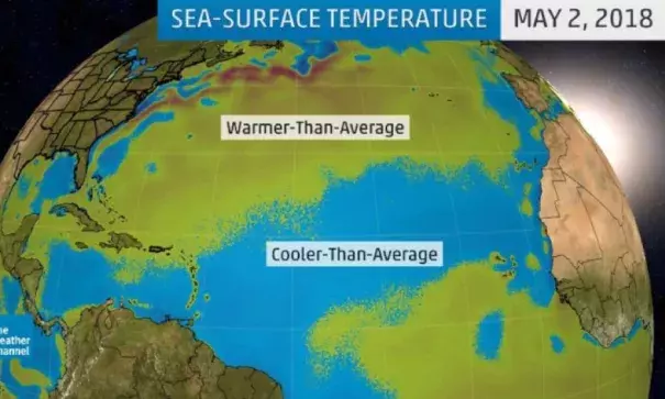
Throughout the main development region (MDR) of the Atlantic Ocean, sea-surface temperatures (SSTs) at the start of May were running nearly a half-degree Celsius below the 1981-2010 average, according to a tweet from Dr. Phil Klotzbach, a tropical scientist at Colorado State University. The MDR is a swath of the tropical Atlantic Ocean that stretches from Africa's western coast into the Caribbean.
This is a change from last year at this time when warmer-than-average SSTs dominated much of the MDR, helping to fuel last year's active hurricane season.
In addition, this swath of the ocean had its coolest final two weeks of April in 18 years, according to a tweet from Michael Lowry, a strategic planner with FEMA and former hurricane specialist at The Weather Channel.
Should the cooler waters persist into summer, it could suppress tropical storm or hurricane development in this region of the Atlantic Ocean.
This is because of the negative effect the cooler waters have on tropical waves as they move westward across the Atlantic Ocean from Africa. If you recall, tropical waves are one of the seeds for tropical storm and hurricane development.
"In terms of Atlantic SSTs and their impacts on tropical waves, anomalously cool water effectively means less fuel for developing tropical cyclones. It also tends to be associated with higher pressure and drier mid-levels in the atmosphere, which both act to suppress the development of strong thunderstorms which are the building blocks of hurricanes," said Klotzbach in an email to weather.com.
Related Content