Headline
Wobbly polar vortex triggers extreme cold air outbreak
Canada
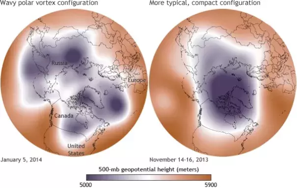
Maps show the 500-millibar geopotential height (the altitude where the air pressure is 500 millibars) on January 5, 2014 (left), and in mid-November 2013 (right). The cold air of the polar vortex is purple, Image: NOAA
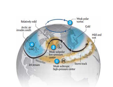
In recent years, climate scientists have noticed that the jet stream has taken on a more wavy shape instead of the more typical oval around the North Pole, leading to outbreaks of colder weather down in the mid-latitudes and milder temperatures in the Arctic, a so-called “warm Arctic-cold continents” pattern. Whether this is normal randomness or related to the significant climate changes occurring in the Arctic is not entirely clear, especially when considering individual events. But less sea ice and snow cover in the Arctic and relatively warmer Arctic air temperatures at the end of autumn suggest a more wavy jet stream pattern and more variability between the straight and wavy pattern
Related Content
Headline
Apr 12, 2016 | Scientific American Blog Network
What Is This Polar Vortex That Is Freezing the U.S.?
Science Source
| Journal of Climate
Linking Siberian Snow Cover to Precursors of Stratospheric Variability
Judah Cohen, Jason C. Furtado, Justin Jones et al
Science Source
| Science
The Siberian snow connection
Carolyn Gramling
Science Source
| Nature Geoscience
Recent Arctic amplification and extreme mid-latitude weather
Judah Cohen, James A. Screen, Jason C. Furtado et al
