Torrential Rains Will Overshadow A Minor Coastal Flood Event Along Northern Gulf Coast
A strengthening area of low pressure tracking towards the northern U.S. Gulf Coast developed into Tropical Storm Cindy on Tuesday. Torrential rains from Louisiana through the Florida Panhandle will grab the spotlight, as destructive winds should not develop and coastal flooding remains minor.

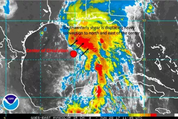
Note the area of tropical storm force winds depicted on the map above. These winds are offset from the center due to southwesterly wind shear. Typically when winds are offset from the center like this, they do not provide consistent coverage over the entire area, but are more found in the heavier squalls. This means that the system is not producing a wide enough coverage of strong winds to generate substantial coastal flooding.
The greatest coastal flood potential exists along the Mississippi Coast and in southeast Louisiana, east of the Mississippi River. Coastal flood levels near the center of circulation, in south central and southwest Louisiana, should be noticeably lower than locations 100+ miles to the east (east of Mississippi River).
...
NOAA's Quantitative Precipitation Forecast (QPF) map depicts a broad area of rain from East Texas through the Florida Panhandle exceeding four inches, the localized amounts exceeding 10 inches through Friday morning.
Keep in mind that "weaker" tropical cyclones, such as minimal tropical storms, often generate heavier rainfall totals than better developed tropical storms and hurricanes. This is counterintuitive to most people, as we may assume that all hazards are worse during higher "category" cyclones. However, weaker tropical storms are not as well developed vertically so they do not tap into the upper level steering winds that would generally give them a faster forward motion. So they tend to stick around for awhile.
Related Content