Science Source
Geodetic measurements reveal similarities between post–Last Glacial Maximum and present-day mass loss from the Greenland ice sheet
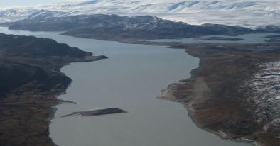
- States that accurate quantification of the millennial-scale mass balance of the Greenland ice sheet (GrIS) and its contribution to global sea-level rise remain challenging because of sparse in situ observations in key regions
- Uses data from the Greenland Global Positioning System network to directly measure GIA and estimate basin-wide mass changes since the LGM
- Finds that there are unpredicted, large GIA uplift rates of +12 mm/year in southeast Greenland
- Finds that these rates are due to low upper mantle viscosity in the region, from when Greenland passed over the Iceland hot spot about 40 million years ago
- Finds this region of concentrated soft rheology has a profound influence on reconstructing the deglaciation history of Greenland
- Reevaluates the evolution of the GrIS since LGM and obtains a loss of 1.5-m sea-level equivalent from the northwest and southeast
- States these same sectors are dominating modern mass loss
- Suggests that the present destabilization of these marine-based sectors may increase sea level for centuries to come
- The new deglaciation history and GIA uplift estimates suggest that studies that use the Gravity Recovery and Climate Experiment satellite mission to infer present-day changes in the GrIS may have erroneously corrected for GIA and underestimated the mass loss by about 20 gigatons/year
Related Content
Science Source
| Geophysical Research Letters
Melting glaciers stimulate large summer phytoplankton blooms in southwest Greenland waters
Kevin R. Arrigo, Gert L. van Dijken, Renato M. Castelao et al
Science Source
| Geophysical Research Letters
Ice Core Records of West Greenland Melt and Climate Forcing
K. A. Graeter, E. C. Osterberg, D. G. Ferris et al
Science Source
| Science Advances
Abrupt shift in the observed runoff from the southwestern Greenland ice sheet
Andreas P. Ahlstrøm, Dorthe Petersen, Peter L. Langen et al
Headline
Dec 15, 2017 | Vox
Greenland's ice sheet is driving global sea level rise. One section is melting 80% faster.
