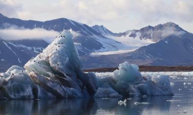
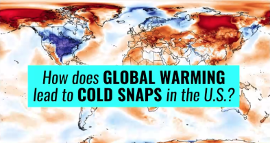
Polar Vortex Split and Eastern US Arctic Invasion January 2019
The polar vortex, the extremely cold air that spins above the Arctic in winter, is typically corralled by the jet stream and the temperature differential between the Arctic and the mid-latitudes. But in early January 2019, the vortex was weakened by an episode of sudden warming in the Arctic stratosphere.[1] It bulged down into North America and Europe, bringing temperatures well below freezing to the Midwest and leading to several deaths.[2]
While climate change warms the planet as whole, it also disrupts regional weather patterns, sometimes displacing cold air to the south. The overall warming trend continues but cold conditions can move. The record setting heat events recently observed further north in parallel to cold conditions in the continental US are consistent with this pattern of disruption.


Climate science at a glance
-
Climate change disrupts regional weather patterns and can bring cold further south while warm air can travel further north.
-
The Arctic is warming twice to three times as fast as the global rate due to the unique feedbacks in the Arctic climate system—a phenomenon known as Arctic amplification.[1]
-
Disruption via Arctic warming affects weather patterns in the mid-latitudes, e.g. the continental United States.
-
Global warming has now gone beyond adding energy to the thermodynamic dimension of our climate and is now the patterns of atmospheric circulation, including the jet stream.
-
Atmospheric blocking due to anomalous, persistent, meandering of the jet stream often causes weather extremes in the midlatitudes.[2]
Background information
Climate change doesn’t mean no more cold weather anywhere ever. It means more warm weather than cold, and that’s what we’ve seen.
The long-term warming trend is clear and undeniable. The past four years have been the hottest on record for the globe, and there hasn’t been a cooler-than-average year in three decades. We’re seeing a lot more record hot weather than record cold, by about a 2 to 1 margin. Cold snaps in the Upper Midwest have become much less frequent. The recent National Climate Assessment explained how warmer winters are allowing pests to kill more trees, which leads to more wildfires; are already decreasing snowpack and costing the winter recreation industry money; and allowed for the northward spread of Lyme disease, among others.
But as NOAA has explained, there’s actually good reason to expect heavier snow storms in some locations, even as we experience less overall cold. And just because the globe is warming overall doesn't mean cold temperatures have been completely eradicated.
There is significant evidence that this particular type of cold snap, known as an extension of the polar vortex, may be a symptom of climate change.
The extremely cold air above the Arctic in winter is typically corralled by the polar vortex jet stream. But there is mounting evidence that the rapid warming of the Arctic is making for a more wavy jet stream, with waves that move more slowly across the globe. When the jet stream gets wavy, cold Arctic air “falls” down into lower latitudes — sometimes into the U.S. Thee link between a slow, wavy jet-stream and extreme U.S. weather is well-established.
We may see more unusual polar vortex behavior in the future.
The Arctic is warming twice to three times as fast as the global rate due to the unique features in the Arctic climate system—a phenomenon known as Arctic amplification. The rapid rise in Arctic temperatures relative to the slower warming elsewhere may be leading to a more meandering jet stream. A warmer Arctic may be causing wintertime weather to get "stuck" more often, with cold air diving south and warm air heading north.
Climate signal #1: Arctic amplification
The Arctic has warmed about twice as fast as the rest of the world. In some places, winter temperatures are as much as 7°F, or almost 4°C warmer than they were just 50 years ago.
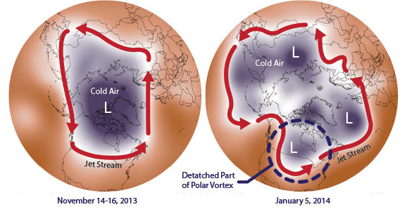 Arctic warming affects weather patterns in the mid-latitudes, where most people live. That's because of the jet stream—a narrow band of strong winds high up in the atmosphere that pushes weather systems along. The jet stream is powered by the temperature difference between the Arctic and the mid-latitudes, and this difference is shrinking as the Arctic warms. Scientists suspect this may be making the jet stream slow down and meander, rather than speeding around the planet as it usually does.
Models report that cold weather Arctic invasions into the eastern US grow more intense in a warming world—a phenomenon of climate disruption sometimes popularly referred to as "global weirding."
Observations consistent with climate signal #1
- The Arctic experienced a sudden stratospheric warming event around January 2. Part of the stratosphere warmed 50 degrees F in the time span of a few days.
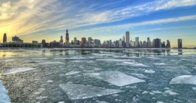
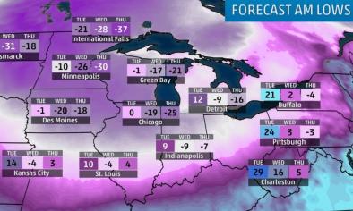
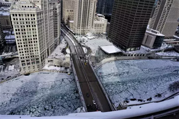
- Several locations set daily record lows the morning of January 30, including Chicago and South Bend, Indiana.[3]
- Several cities in Iowa set daily record lows on January 30 as well, including Des Moines (-20 degrees F), Waterloo (-25), Mason City (-28), Estherville (-29), Ames (-22), Lamoni (-20) and Ottumwa (-21).[4]
- January 30 was the second-coldest day on record in Chicago.[5]
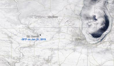
- On January 31, Moline, IL set an all-time record low of -33 degrees F and Rockford, IL, set an all-time record low of -30 degrees F.[5]
- Also on January 31, daily record lows were set in four cities in Wisconsin: Appleton (-26 degrees F), Oshkosh (-26), Green Bay (-26) and Marshfield (-30).[6]
- International Falls, MN broke its previous daily record low for January 31 by a full 10 degrees F. The new record is -45 degrees F.[7]
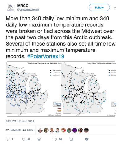
- Over 340 daily low minimum and 340 daily low maximum records were broken or tied on January 30 and 31 in the Midwest.[8]
Climate signal #2: Atmospheric blocking increase
Wintertime circulation is likely getting "stuck" more often due to a warmer Arctic.
Atmospheric blocking occurs when waviness in the jet stream causes congestion. Blocking events are associated with long-lasting and slow-moving high-pressure systems that "block" westerly winds in the mid- and high-latitudes, causing the normal eastward progress of weather systems to stall. A major block can produce long stretches of blazing heat in the summer or bitter cold in the winter.[9] If a storm is stalled by atmospheric blocking, it will keep dumping precipitation on the ground below, leading to higher rainfall or snowfall totals than would otherwise have occurred.
Scientists have observed heavier-than-normal snowfalls in the Midwest and Northeast US in recent years, with little snow in other years.[10] These observations are consistent with indications of increased blocking of the wintertime circulation of the Northern Hemisphere.[11]
Observations consistent with climate signal #2
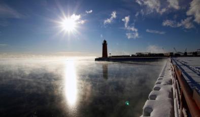
- Chicago (at O'Hare) saw sub-zero temperatures for 52 consecutive hours from January 29-31.[12]
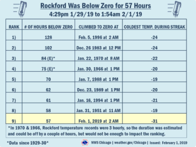
- Rockford, IL remained below zero for 57 consecutive hours from January 29-February 1.[13]
Climate signal #3: Extreme precipitation increase
Global warming leads to an increase in both ocean evaporation into the atmosphere and the amount of water vapor the atmosphere can hold when fully saturated. Warmer air holding more moisture creates conditions more favorable for heavy precipitation in the form of intense rain and snow storms.
Temperatures in the Goldilocks range of between about 28°F and 32°F, accompanied by moisture, mean more snow. During nor'easters, a sharp contrast between cold continental air and a relatively warm ocean permits the storms to tap moisture fed by high sea surface temperatures and convert it into exceptional snowfall.[14]
The temperature contrast between warm offshore waters and cooler conditions over land powers nor’easters. Current Atlantic ocean temperatures are unusually warm, providing extra fuel to the storm, leading to a potential “weather bomb.” Such strengthening of nor’easters is consistent with long-term global warming trends.[15]
The amplification of these physical mechanisms can be seen in the long-term trends. There were twice as many extreme regional snowstorms in the US between 1961 and 2010, compared to 1900 to 1960.[16] In New York City, 6 of the top 10 snowfall events since 1869 for Central Park have occurred since 2000.[17]
Related Content