Atlantic hurricanes' rapid growth spurts are intensifying
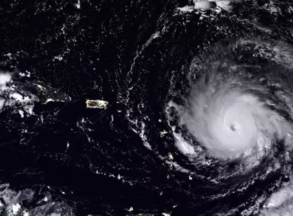
Hurricane Maria, which devastated the Caribbean in September, took just three days to grow from a tropical depression to a fully fledged category 5 storm as it marched across the Atlantic Ocean. A study now suggests that this type of dramatic growth spurt has become more pronounced in hurricanes over some parts of the Atlantic during the past three decades.
Understanding rapid intensification — in which hurricanes increase their maximum sustained winds by 30 knots or more in 24 hours — is important because higher wind speeds cause more damage if a storm makes landfall. “This is how strong a hurricane can become,” says Ruby Leung, an atmospheric scientist at the Pacific Northwest National Laboratory in Richland, Washington. “Rapid intensification has happened with larger amplitude over the last 30 years.”
Wild weather
In 2017, four Atlantic hurricanes — Harvey, Irma, Jose and Maria — underwent rapid intensification. All went on to lay waste to parts of the Caribbean or the United States.
Inspired by this year’s wild storm season, Leung decided to study long-term trends in rapid intensification. Warming ocean waters are expected to lead to storms intensifying more frequently and more severely, says Kerry Emanuel, a meteorologist at the Massachusetts Institute of Technology in Cambridge who has published on the topic. “We’ve shown that theoretically.”
One study this year looked at whether the number of Atlantic hurricanes that undergo rapid intensification had increased between 1950 and 2014; it found no evidence to support that idea. But Leung wanted to explore the magnitude of such changes, rather than how frequently they occurred.
She and her colleagues went through a US National Hurricane Center database that captures the paths and strengths of hurricanes over time. The scientists examined how much each storm between 1986 and 2015 intensified as it moved across the Atlantic.
In general, there was no significant difference in the amount of intensification storms showed over the years. But that changed when Leung and her colleagues looked only at the storms that intensified the most. For these, the average intensification increased by nearly 0.4 knots per day each year.
Changing patterns
This trend held for storms in the central and eastern tropical Atlantic, but not in the western Atlantic. Leung isn't yet sure why that is the case, but it may have something to do with a long-term climate pattern called the Atlantic Multidecadal Oscillation (AMO), which affects interactions between the ocean and atmosphere. Over the past three decades, the AMO has been shifting phase in a way that causes sea surface temperatures in parts of the Atlantic to rise. Warmer ocean waters mean more energy for hurricanes to feed off.
Global warming probably also plays a part in the increased intensification, Leung says. Next, her team wants to try to untangle how much of the change comes from global warming and how much from natural patterns such as the AMO.
Related Content