The lethal atmospheric setup behind a deadly Arctic outbreak
Climate Signals Summary: There are three things to consider when squaring this extreme winter weather with climate change: cold weather doesn’t cancel out decades of warming; rapid Arctic warming is associated with disruptive winter weather in the US; and cold events aren’t as cold as they would have been without climate change.
Article Excerpt: Looking back, it’s clear this extreme weather pattern had been incubating for a while. It began in early January with a perturbation of the polar vortex. That disruption knocked the whirling eddy of bitter cold air and low pressure off-kilter, resulting in upper-atmospheric warming that displaced cold air to the mid-latitudes.
According to Judah Cohen, director of seasonal forecasting at Atmospheric and Environmental Research, that sudden stratospheric warming was integral in helping us get to where we are now.
“We had sudden stratospheric warming for much of January with high pressure and a warm Arctic in the polar stratosphere,” Cohen wrote. “This in turn favored high latitude blocking, in particular across the North American Arctic.”
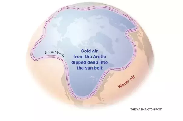
High-latitude blocking, or the establishment of stagnant high pressure in northern regions, is one of the main features that drives cold air down into the Lower 48.
...
Meanwhile, another ingredient — the Arctic Oscillation — supported a weak, wavy jet stream also instrumental in transporting cold air south.
The Arctic Oscillation (AO) is an index defined by the surface atmospheric pressure patterns at latitudes near the North Pole. When the AO index is positive, the mid-latitude jet stream is stronger, keeping the really cold air locked up in far northern regions. When the AO index is negative, it reflects a weaker jet stream that develops wiggles and dips, allowing the frigid air near the pole to ooze into mid-latitudes. Where exactly those jet stream dips set up across the Northern Hemisphere dictates who will see the coldest weather.
Over the course of the winter, the AO remained negative. Over the past week, the index reached its greatest negative value for the entire winter — accounting for the southward dive of the jet stream and outbreak of cold air battering the Lower 48.
Added together, it was the Arctic high pressure that provided the cold air, and an errant jet stream channeled that cold air into place over the nation’s heartland.
There is some evidence that rapid climate change in the Arctic, which is melting sea ice, is helping to disrupt larger-scale weather patterns in the Northern Hemisphere, which may make incursions of polar air more likely and lead to extreme heat waves during the summer. This is still an area of active scientific research, however.
Related Content