NASA looks at historic flooding from slow-moving Maryland storms
NASA analyzed rainfall data from slow-moving storms that triggered flash floods over parts of central Maryland and caused devastating flooding in historic Ellicott City, Maryland.
A slow-moving line of heavy thunderstorms dumped as much as 6 to 7 inches of rain in about two hours' time during the evening of Saturday, July 30, over parts of Howard County in central Maryland, resulting in severe local flash flooding.
The hardest hit area was the historic town of Ellicott City, where two people were trapped in their cars and drowned. The town suffered substantial damage to many buildings, numerous cars were tossed about, and around 150 people had to be rescued from the downtown area. The heavy rains and flooding were a result of successive waves of rather slow moving storms that merged over the area.
NOAA's National Weather Service (NWS) in Baltimore issued a public information statement about the flooding on July 31, calling it "historic heavy rainfall Saturday in Ellicott City." NWS noted that extremely heavy rain fell and a rain gauge provided by Howard County to the National Weather Service measured 6.5 inches.
A warm, humid air mass, a stationary frontal boundary, and rather weak winds aloft set the stage for the slow-moving storms. Earlier in the afternoon, storms formed up and organized along the Appalachian Mountains before moving slowly out across the Piedmont. The Piedmont is a plateau area between the Atlantic coastal plain and the Appalachians.
...
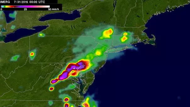
NASA's Integrated Multi-satellite Retrievals for GPM, or IMERG, is used to make estimates of precipitation from a combination of passive microwave sensors, including the GMI microwave sensor on board the GPM, or Global Precipitation Measurement, mission satellite, and geostationary IR (infrared) data. These data were used to create images and animations at NASA's Goddard Space Flight Center in Greenbelt, Maryland. GPM is a joint mission between NASA and the Japan Aerospace Exploration Agency.
One image created showed instantaneous IMERG-estimated rainfall rates at 8 p.m. EDT on July 30 (12 a.m. UTC on July 31), 2016. IMERG showed a strong band of heavy rain extending east-west over north-central Maryland extending southwestward into northern Virginia. Within this band, rain rates are generally on the order of an inch per hour with localized areas of higher rates
IMERG was also used to estimate rainfall totals for the period from July 20 at 4 p.m. EDT (8 p.m. UTC) to July 31 at 6 a.m. EDT (10 a.m. UTC). Rainfall totals across central Maryland were on the order of more than 3 inches (70 mm)
Related Content