Headline
Aerial Survey Program critical to battling tree mortality
United States
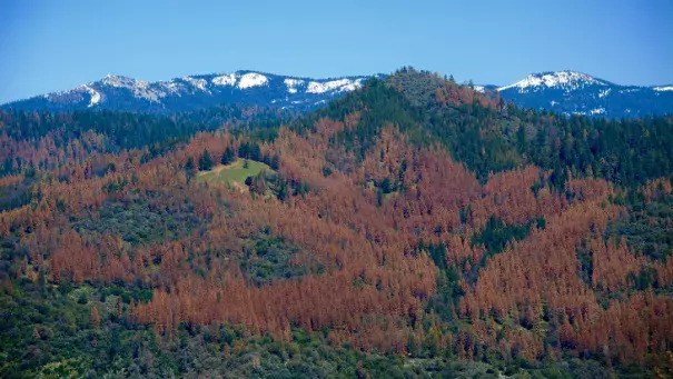
The U.S. Forest Service’s aerial survey team estimates tree mortality in California by flying over the forests and observing the canopy's texture and color. Photo: USDA
With tree mortality rising to an estimated record-high 27.6 million trees in California in 2015, the role of the U.S. Forest Service’s aerial survey team is more critical than ever.
The U.S. Forest Service began aerial survey detection in the Pacific Northwest Region in the 1950s, with a small program in the Pacific Southwest Region (California) established in the 1990s.
Last year, Aerial Survey Program Manager Jeffrey Moore and his team discovered nearly 10 times more dead trees than the previously recorded high of 3.3 million in 2014
Related Content
Science Source
| AMS Journal of Climate
Is There a Role for Human-Induced Climate Change in the Precipitation Decline that Drove the California Drought?
Richard Seager, Naomi Henderson, Mark A. Cane et al
Science Source
| AMS Journal of Hydrometeorology
Indications for Protracted Groundwater Depletion after Drought over the Central Valley of California
S.-Y. Simon Wang
Science Source
| Bulletin of the American Meteorological Society
EEE 2013: Causes of the Extreme Dry Conditions Over California During Early 2013
Hailan Wang and Siegfried Schubert
Science Source
| Nature Climate Change
California from drought to deluge
S.-Y. Simon Wang, Jin-Ho Yoon, Emily Becker and Robert Gillies
