Amphan to Push Massive Storm Surge Toward Eastern India and Bangladesh
Climate Signals Summary: A record-breaking storm, Cyclone Amphan, is forecast to land in India and Bangladesh on Wednesday, May 20, in the late afternoon local time (see live tracking here). Just last year, the Bay of Bengal saw another intense and destructive cyclone, Cyclone Fani, driven by unusually warm sea surface temperatures.
Climate change is increasing the damage that cyclones such as Amphan cause in several ways, including:
- Increasing sea surface temperatures which raises the maximum potential energy that a storm can reach
- Increasing the rainfall that drops during the storm,
- Raising sea levels, which increases the distance inland that storm surges reach,
- Causing storms to gain strength more quickly.
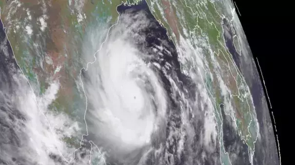
Article Excerpt: After a spectacular bout of rapid intensification on Sunday, Tropical Cyclone Amphan poses a grave storm-surge threat to the highly vulnerable coastline of the upper Bay of Bengal. The Joint Typhoon Warning Center (JTWC) upgraded Amphan to the equivalent of Category 5 strength at 2 am EDT Monday, with top 1-minute sustained winds estimated at 140 knots (160 mph).
On the scale used by the Indian Meteorological Department (IMD), Amphan was upgraded at 3 am EDT Monday to the highest possible level: super cyclonic storm. Only a handful of storms—about one per decade—achieve this level, which corresponds to a three-minute-averaged wind speed of 120 knots (140 mph). Hurricane ratings by the National Hurricane Center and JTWC are based on one-minute averaging, which will yield higher wind speeds for a given storm.
Amphan took advantage of very favorable conditions in the southern Bay of Bengal to strengthen incredibly quickly over the weekend. Drawing on very warm sea surface temperatures of 31°C (88°F), high oceanic heat content, and light wind shear, Amphan bolted from minimal tropical storm strength (35 knots or 40 mph) to Category 5 equivalent strength (140 knots or 160 mph) in just 48 hours—and from minimal hurricane strength (65 knots or 75 mph) to Cat 5 equivalent strength in just 24 hours.
...
The most serious threat posed by Amphan is potentially catastrophic storm surge. Even if Amphan's top winds weaken, the storm surge threat will remain dire. Amphan is a large cyclone that is already pushing a tremendous amount of water northward into the Bay of Bengal, which exerts a funneling effect on northward-moving cyclones. Any minor weakening of Amphan’s winds from an eyewall replacement cycle would have little immediate effect on mitigating the storm surge threat, which has already been put into motion (literally). There is a great deal of momentum in the water pushed by large, powerful storms even after they weaken, as evidenced by 2008's Hurricane Ike in Texas and 2012's Hurricane Sandy in New Jersey and New York.
IMD is warning that a surge of up to 4–6 meters (13–20 feet) is possible over parts of West Bengal, with 3-4 m (10-13 ft) possible into Bangladesh.
