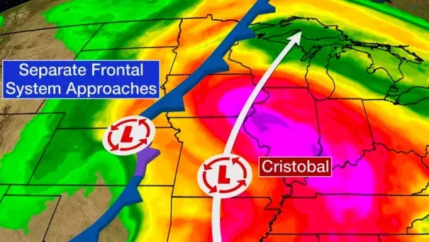
Cristobal's Inland Track to Bring Heavy Rain, Gusty Winds and Isolated Tornadoes to the Midwest on Tuesday
Climate Signals Summary: The 2020 Atlantic hurricane season is off to a record-breaking start. There were two storms in May, before the season's official start on June 1, and Cristobal’s formation on June 2 is the earliest date that a third storm has ever formed in the Atlantic. Forecasters expect, and early indicators suggest, that the 2020 Atlantic hurricane season is going to be unusually active, and there are strong ties between climate change and observed increases in Atlantic hurricane activity.
Article Excerpt: Interestingly, Cristobal is expected to be only the fourth Atlantic tropical cyclone remnant to move over Wisconsin in more than a century of records, according to the National Weather Service office in Milwaukee. If Cristobal remains a tropical depression when it crosses into Wisconsin, it would be the first tropical depression on record in the state.
...
U.S. Recap, Notables
On June 2, Cristobal became the earliest-in-season third named Atlantic storm, breaking a record previously held by Tropical Storm Colin on June 5, 2016.
In an average season, the third named storm arrives by Aug. 13, according to the National Hurricane Center.
Last year, the "C" storm, Chantal, didn't develop until Aug. 20.
Cristobal was the second-earliest landfalling named storm on record in Louisiana, according to Dr. Phil Klotzbach, tropical scientist at Colorado State University.
The NHC said Cristobal made landfall along the coast of southeastern Louisiana between the mouth of the Mississippi River and Grand Isle at 5 p.m. CDT Sunday evening. Maximum sustained winds at the time were estimated near 50 mph.
Late Sunday afternoon, New Orleans set a new record-low sea-level pressure for the month of June as Cristobal approached the coast of southeastern Louisiana. The pressure in New Orleans dipped to 995.5 millibars at 4:27 p.m. CDT Sunday, and the previous record was 998.6 millibars set during Tropical Storm Bill on June 30, 2003, according to David Roth, a meteorologist at NOAA's Weather Prediction Center.
A tornado touched down in eastern Orlando near downtown early Saturday evening. A few funnel clouds and waterspouts were also reported, especially in the Florida Peninsula.
Rainfall rates of 3 to 6 inches per hour Sunday morning triggered significant flash flooding in parts of downtown Jacksonville, Florida, trapping cars.
Farther west, one observer near Hopewell, Florida (Madison County), reported 12.09 inches of rain in the 48 hours ending 5 p.m. EDT Sunday. Topping that total, a weather station in Suwannee Springs, Florida, reported 13.03 inches of rain between midnight and 8 p.m. EDT Sunday.
Water levels were running about 6.2 feet above normal tide level Sunday afternoon at Shell Beach, Louisiana, along the Mississippi River Gulf Outlet, southeast of New Orleans near the southern shore of Lake Borgne.
In New Orleans, storm surge was surpassing 3.5 feet on the south shore of Lake Pontchartrain Sunday afternoon, causing water to pile up on Lakeshore Drive.
Storm surge caused water to cover roads near Waveland and Bay St. Louis, Mississippi, where water levels were nearly 6 feet above normal Sunday afternoon.
