Potentially Catastrophic Cyclone Fani Nears Landfall in India with 155-mph Winds
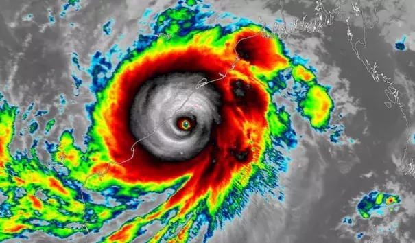
After powering to top-end Category 4 strength, Tropical Cyclone Fani is taking a bead on the northeast coast of India as one of the most intense storms on record to threaten the region, prompting millions to evacuate. Fani’s top sustained winds had increased to 155 mph—just 2 mph shy of Category 5—as of 12Z (8 am EDT) Thursday, according to the Joint Typhoon Warning Center (JTWC). Fani could briefly intensify to Category 5 strength before an expected landfall on Friday morning local time, or IST (Thursday night EDT) within 50 miles of the city of Puri (population 200,000).
Satellite images on Thursday morning EDT show a forbidding cyclone, with a crisp eye about 15 miles wide surrounded by a core of intense thunderstorms. With warm sea-surface temperatures in its path, and very favorable upper-level outflow, conditions are nearly ideal for Fani to maintain most or all of its strength in the remaining time before landfall.
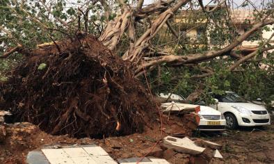
JTWC predicts that Fani will still be a powerful Category 4 storm just before landfall. The Indian Meteorological Department (IMD) is predicting a landfall intensity of Category 3. Regardless of any potential weakening before landfall, Fani will push destructive winds and a potentially catastrophic storm surge across the coast of India’s Odisha state near and east of Puri.
...
More than 3 million people have already been evacuated from parts of Odisha state, according to the Times of India. The state plans to evacuate a total of 11 million people, which would be the largest weather-related evacuation in the history of India and one of the largest in world history.
...
The official forecast from the IMD as of 12Z Thursday was for surge levels of up to 1.5 meters (4.9 feet) across low-lying areas of Ganjam, Khurda, Puri & Jagatsinghpur Districts.