Headline
Sunday Fog - March Returns This Week - Turbocharged El Nino
United States
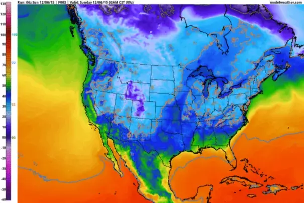
NAM guidance shows the spastic journeys of the 32F isotherm over the next 84 hours (highlighted in orange). For at least the next 4-5 days nighttime lows will be a few degrees warmer than average highs this time of year. Image: NOAA and AerisWeather.
The symptoms of a warming climate are becoming harder to deny. Like 4 separate thousand-year floods in Minnesota since 2004. Or 50F and rain in December. This is "weather" but all weather is being flavored by warming now underway...Today will be gray and foggy but 40s linger most of this week; a few newly snowless towns may report 50F midweek. Rain showers are possible late Tuesday; again Thursday as a puff of Canadian air arrives. More mid-March than mid-December...The forecast temperature anomalies (in Fahrenheit) Saturday morning show a huge area of relative warmth; temperatures forecast to be as much as 25-35F warmer than average for December 12. This will manifest itself in a series of records, mostly record-warm nighttime mins.
Related Content
Headline
Jan 3, 2016 | WxShift
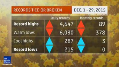
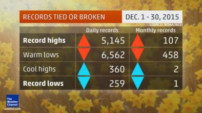
Two Charts Show December’s Crazy Warmth
Headline

Dec 18, 2015 | Bloomberg
New York's Tropical December Days: Climate Change or El Nino?
Headline

Dec 16, 2015 | The Atlantic
70-Degree Days in December: What?
Headline
Dec 16, 2015 | Weather Underground
More Than 1,000 Daily Records Broken as December Warmth Continues in the East
