Headline
These US cities are most at risk for Zika this summer. (But don't panic.)
United States
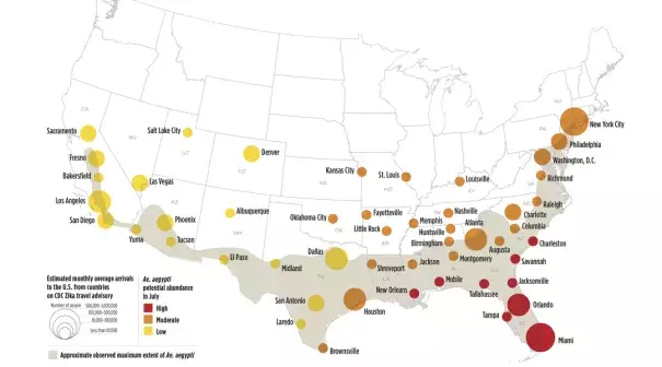
Image based on data mapped by Olga Wilhelmi, NCAR GIS program.
The National Center for Atmospheric Research produced the map above after analyzing the relative Zika risk of 50 US cities. Its research, which was published online today in PLOS Current Outbreaks, combines meteorological records, simulation of Aedes aegypti mosquito population growth, estimates of human-mosquito exposure, and transportation data
Related Content
Science Source
| The Lancet
El Niño and climate change—contributing factors in the dispersal of Zika virus in the Americas? - The Lancet
Shlomit Paz, Jan C Semenza
Science Source
| Proceedings of the National Academy of Sciences
Global risk model for vector-borne transmission of Zika virus reveals the role of El Niño 2015
Cyril Caminade, Joanne Turner, Soeren Metelmann et al
Headline
Apr 7, 2017 | Carbon Brief
Zika outbreak ‘fuelled by’ El Niño and climate change
Science Source
| MMWR. Morbidity and Mortality Weekly Report
Vital Signs: Update on Zika Virus–Associated Birth Defects and Evaluation of All U.S. Infants with Congenital Zika Virus Exposure — U.S. Zika Pregnancy Registry, 2016
Megan R. Reynolds, MPH; Abbey M. Jones, MPH; Emily E. Petersen et al
