You've Never Seen a Map of Antarctica Like This Before
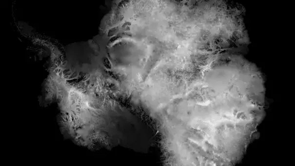
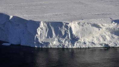
The ethereal black and white image shows the thickness of all of Antarctica’s ice. It speaks to both the grandeur of the seventh continent and human ingenuity. Why humanity is on a course to melt all that ice is beyond me.
The map comes courtesy of Kevin Pluck, a software engineer, statistician, and animator, who pulled a massive dataset of Antarctic ice known as Bedmap2 for a project he was working on (more on that in a moment). The dataset is the compilation of a number of different observing methods, including airborne radar and satellite measurements. It took scientists years to compile and is one of the most comprehensive datasets of Antarctica’s ice and underlying bedrock.
“After downloading the enormous data files, I needed a way to check that I had processed them correctly so I thought the simplest way to do it was to plot a grey pixel based on the thickness value,” Pluck told Earther via Twitter direct message. “Out popped what you see here. I was stunned, I had never seen something so beautiful come from pure data before.”
...
The white areas are where the ice is thickest, with the towering and stable ice sheet of East Antarctica standing out most prominently. The Antarctic Peninsula—home to the Larsen C ice shelf that calved a huge iceberg last year—drifts off in the ocean in the upper left corner, but it’s that ghostly patch of gray and black in the lower left that had Pluck downloading the data in the first place.
The glaciers that hold back West Antarctica are the weakest links in the icy armor ringing the continent. They could already be in a state of unstoppable collapse that will unfold over centuries, causing seas to rise by up to 10 feet. But some scientists are growing concerned that changes could happen even more rapidly due to something called marine ice cliff instability, where a quirk of geology could create enormous problems.
Related Content