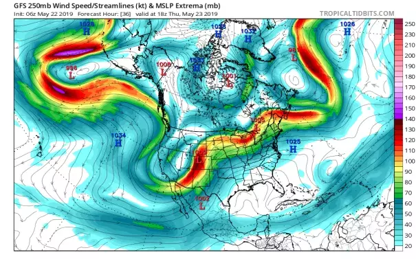
Map: 250mb forecast for May 23, 2019
When wacky weather strikes, it's always the jet stream that's causing it. The jet stream is responsible for almost all weather in the US, except for the formation and intensity of tropical storms and highly local effects.
In this particular case, we are seeing yet another instance of a very persistent jet-stream pattern, with a deep trough (southward dip) in the west and a strong ridge (northward bulge) in the east (see below). Unusual rains in CA and cold over the Rockies are associated with the trough, while above-average temperatures over much of the east are caused by the ridge. Between the ridge and trough, where the jet's winds are blowing from the southwest, is a clashing of the cold and warm along with a lot of upper-level energy. These are the ingredients for severe weather in the Midwest. As pulses of energy revolve around the trough then enter the Midwest, new batches of strong storms erupt, bringing heavy rains and a high likelihood of thunder, hail, microbursts, and tornadoes. This pattern is predicted to continue until early next week, at least.
