Science Source
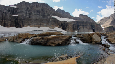
Shrinkage of Sperry and Grinnell Glaciers, Glacier National Park, Montana
A warming climate is melting the namesake glaciers of Glacier National Park, Montana, USA. James Dyson’s 1948 paper was one of the earliest publications to emphasize climate change impacts to the cryosphere through an examination of Sperry and Grinnell Glaciers. This paper, combined with his subsequent works, acts as a pillar for current glacier monitoring efforts.
- States that the National Park Service has measured the yearly recession of the fronts of several glaciers in Glacier National Park, Montana since 1931; however, the measurements gave little indication regarding the amount of ice shrinkage
- States that in 1937 the Park Service initiated a mapping program of a detailed topographic map of Grinnell Glacier, with similar maps made of Sperry Glacier in 1938, Jackson Glacier in 1939, and Sperry and Grinnel Glaciers in 1946
- States that the remapping of Sperry and Grinnell yielded comprehensive quantitative determinations of their shrinkage between the surveys
- States the maps show a phenomenal reduction in volume, expressed both in lowering of the surface and in decrease in area
- Finds shrinkage was exhibited by all the 60 to 80 glaciers within the boundaries of Glacier National Park
- Finds that the Sperry Glacier, the largest in Glacier National Park, with the possible exception of one or more of the Dinwoody glaciers in Wyoming's Wind River Range, had a surface area of about 1.31 square miles in 1901 (or almost 840 acres), and had shrunk to 390 acres by 1938, and to 330 acres by 1946
- Finds that the Sperry Glacier experienced significant lowering of the surface; between September, 1938, and September, 1946, the surface of the lowermost I87 acres (somewhat more than half the total area) was lowered by ablation at the rate of 9.75 feet, representing a loss in volume of 3,397,680 cubic fet an acre in the 8-year period

- States that the Grinnell Glacier experienced slow shrinkage between 1850 and 1900, and that the rate increased progressively to a maximum sometime within the period 1930 to 1940
- States that on or about August 14, 1946, at the northern terminus where the ice is bordered by a small marginal lake, a section of the Grinnell Glacier 700 feet long and 100 feet wide broke off and fell into the lake—this was the largest case of calving recorded at Grinnell Glacier


- Summarizes findings, saying that although considerable recession of glaciers in Glacier National Park occurred between I850 and 1900, the rate became much more rapid early in the present century
- Concludes that if Sperry and Grinnell Glaciers do not reach hydrological equilibrium within the next five or ten years, they will be reduced to a stagnant condition and thus be doomed to extinction
Related Content
Real Time Data

Nov 22, 2016 | National Snow and Ice Data Center
Global Land Ice Measurements from Space (GLIMS)
Headline

Nov 22, 2016 | CNN
Montana's melting glaciers: The poster-child for climate change
Headline

Nov 22, 2016 | Mother Jones
7 More National Parks Threatened by Fire
Science Source
| Climatic Change
Changes in snowmelt runoff timing in Western North America under a 'business as usual' climate change scenario
Iris Stewart, Daniel Cayan, and Michael Dettinger


