Science Source
Synoptic and quantitative attributions of the extreme precipitation leading to the August 2016 Louisiana flood
- States that the catastrophic August 2016 flood in the U.S. state of Louisiana was a result of intense precipitation produced by a slow‐moving tropical low‐pressure system interacting with an eastward traveling baroclinic trough to the north
- States that while tropical‐midlatitude interactions of this nature are rare, they are not unprecedented
- Analyses presented point toward the tendency for more and perhaps stronger upper level troughs propagating out of the western U.S. in summer; these then have an increasing potential to cross paths with low‐pressure systems that form around the Gulf Coast
- Finds that, combined with the projected increase in precipitable water, resulting precipitation magnitude would increase
- Large‐ensemble modeling indicates that the prospect of future tropical‐midlatitude interactions is a scenario that Louisiana will face in the future
- Regional simulations estimate that the climate warming since 1985 may have increased the event precipitation (11–14 August 2016) on the order of 20%, all of which allude to a conceivable forecast of nonhurricane‐related, warm season extreme precipitation in the Gulf Coast states
Related Content
Headline
Jan 10, 2017 | NOAA Climate.gov
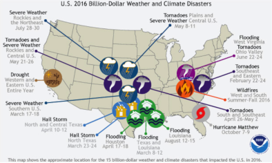
2016: A historic year for billion-dollar weather and climate disasters in U.S.
Science Source
| Geophysical Research Letters
Recent trends in U.S. flood risk
Slater, Louise J., Villarini et al
Real Time Data
Oct 13, 2016 | NOAA
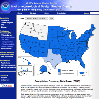
US Precipitation Frequency Data Server
Science Source
| Journal of Climate
Global Water Vapor Trend from 1988 to 2011 and Its Diurnal Asymmetry Based on GPS, Radiosonde, and Microwave Satellite Measurements
Wang, Dai, and Mears
