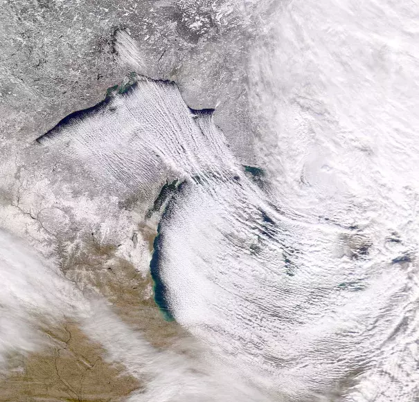
Extreme Buffalo Lake-Effect Snow November 2014
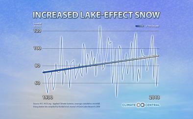
Climate change has already led to heavier-than-normal snowfalls in the Northeast. This may be due to increasingly slow and stagnant air patterns that lock in wintry conditions. Lake-effect snow led to a particularly intense situation in Buffalo, NY at the end of 2014.
Arctic air in the US signals wacky jet stream behavior with consequences compounded by lake-effect snow
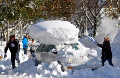
As global temperatures were looking to set a new record near the end of 2014, the US endured over a week of unseasonably wintry conditions due to atmospheric blocking—a large scale pressure pattern with little or no movement—that led to a sustained outbreak of record cold mid-November Arctic air. The most eye-opening consequence of the cold streak was the extreme amount of snowfall—made worse by lake-effect snow—in Buffalo, New York. According to the US National Climate Assessment, climate change has already led to heavier-than-normal snowfalls in the Northeast with indications that wintertime atmospheric patterns are increasingly prone to blocking, or stagnation, that locks in wintry conditions.
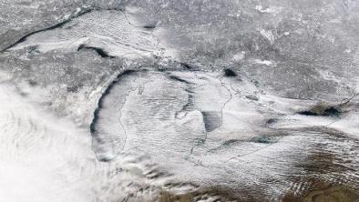
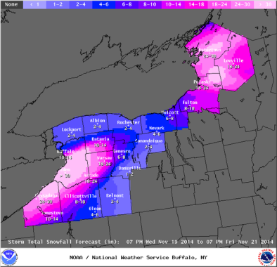
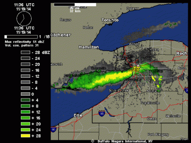
While lake-effect snow is considered common downwind of the North American Great Lakes during late fall and winter, the severity of the 2014 lake-effect snow event in Buffalo was very unusual. On November 18, several counties in and around Buffalo—which lies on the eastern edge of Lake Erie—experienced extreme lake-effect snowfall. Seventy-two inches fell in two days, coming close to the US 24-hour snowfall record of 76 inches set back in 1921 in Colorado.
Many climate change signals may have contributed to the outbreak of Arctic air and extreme lake-effect snowfall in Buffalo. Super Typhoon Nuri, fed by above average water temperatures, kicked off the event by traveling further north than usual and pushing the jet stream south into the US. Warming in the Arctic may also have slowed the jet stream, making it easier for Nuri to push the jet stream and frigid sub-Arctic conditions to the south. The extreme difference between the frigid air temperature and Lake Erie's water temperature led to an intensification of the lake-effect snowfall in Buffalo, which buried the city as cold winds moved across the lake water.
Two major theories link climate change to unusual jet stream behavior
Like the polar vortex of winter 2013-2014, the Arctic air outbreak and extreme amount of lake-effect snowfall in Buffalo was triggered by a high-pressure system in the Pacific Ocean and western US that has led to an extreme, southward sinking jet stream and atmospheric blocking. While the sinking of the jet stream was fueled in part by the strong extra-tropical remnant of Typhoon Nuri, scientists have observed an unusual number of extreme jet stream patterns like this in recent years and are advancing two main theories that might help to explain why.
One prominent theory links the unusual jet stream behavior to Arctic amplification, or enhanced warming in high northern latitudes relative to the northern hemisphere. The second leading theory suggests unusual atmospheric patterns may be tied to increased water temperatures in the Pacific Ocean. This latter theory, in addition to helping to explain unusual jet stream patterns, may also explain Typhoon Nuri’s intensity.
Ocean warming can make tropical storms more intense, driving big dips in the jet stream
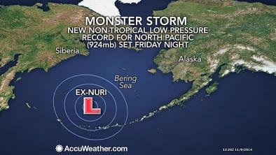
Atmospheric conditions over the Pacific Ocean helped trigger the southern outbreak of Arctic air into the US. This is because warmer than average ocean water intensified Super Typhoon Nuri, which became 2014's second most intense tropical cyclone. Once Typhoon Nuri moved to higher latitudes and transformed into an extra-tropical cyclone, it gained force and became the most powerful storm to ever move over the Bering Sea in recorded history. The system led to a large-scale pressure pattern and caused the jet stream to sink southward bringing Arctic condition to the United States.
The research of Kevin Trenberth and his team connects the Pacific Ocean’s influence on the atmosphere to many of the regional atmospheric anomalies we’ve seen in the United States. According to Trenberth, the Arctic outbreak, "started with exceptionally warm sea temperatures in the Pacific that led to the super Typhoon Nuri.” He goes on to say, “The oceans are warmer and there is five percent more moisture in the air over the oceans than prior to 1970…and the extra moisture fuels storms like Haiyan and Nuri and indeed adds a bit more volatility to the weather."
Arctic warming also implicated in unusual jet stream behavior
Other scientists have linked unusual jet stream behavior to Arctic amplification, which is just a fancy way of saying the Arctic is warming at a faster rate than the planet as a whole. Relative to the northern hemisphere, the Arctic has warmed approximately twice as fast. During the summer, the Arctic absorbs extra solar energy that it then releases into the atmosphere as heat during the fall.
Scientists are actively investigating how the Arctic's release of heat into the atmosphere impacts large-scale atmospheric circulation. Jennifer Francis has theorized that Arctic warming causes jet streams to weaken and to have larger north-south waves. According to Francis' research, when these waves get larger, they move more slowly. The slowing of those waves can cause weather systems to move more slowly, and even become stuck in place. This in turn increases the likelihood of disasters caused by persistent weather conditions, including droughts, heat waves, floods, long cold spells, and heavy snows.
Lake-Effect Snow and Possible Climate Connections
The major climate connection to the lake-effect snow event is the above-mentioned behavior of the jet stream. The southern jet stream introduced unseasonal Arctic temperatures that were much colder than Lake Erie's average water temperatures, and this resulted in a water-air temperature difference approaching 50°F. This, in the words of meteorologist Eric Holthaus, caused a “highly unstable atmosphere, in which thundersnow flourished and snow totals skyrocketed.”
Scientists also expect that climate change will intensify the lake-snow effect through increased water temperatures (though Lake Erie’s temperatures during this event were average for November). Warmer water temperatures increase the water-to-air flux that feeds additional moisture to storms. They also have the potential to push back the date at which ice develops and can reduce overall ice coverage and thickness. As a general rule, the more open water exposed to storm systems, the greater the amount of lake-effect snow.
Scientists are also observing long-term changes in ice cover as a result of climate change (though it was too early for ice on Lake Erie during this event). Annual mean ice cover in all the Great Lakes shows a significant negative trend, indicating that the ice extent in the Great Lakes has been decreasing since the 1970s.
Much of the science is quite new, and scientists acknowledge that much more research is needed before we can fully understand the relationship between climate change, the jet stream, and lake-effect snow. That said, the research done so far points toward a more complete picture of the impacts climate change may already be having and what we might expect in the future.
Related Content


