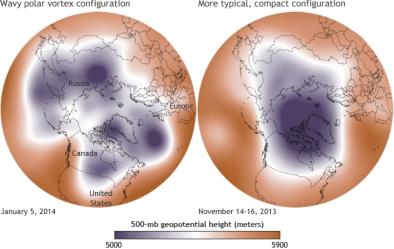
Polar Vortex January 2014
The Arctic is warming even faster than the rest of the globe, and this may be disrupting the path of the jet stream, causing it to form large waves that allow cold Arctic air to periodically move south and cover the continental US.

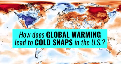
Extreme cold in the US may be a signal of Arctic warming
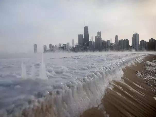
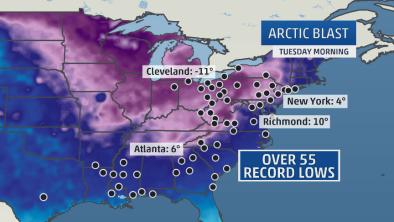
During the first week of 2014, states across the eastern half of the United States—as far south as Alabama and Georgia and as far west as Montana—experienced subzero temperatures due to a weakened polar vortex and consequent kink in the polar jet stream that had Arctic air flowing much further south than it usually would. In much of the Midwest, persistent winds pushed wind chills into "life-threatening territory," reaching 40 below to 60 below zero. In weather that cold, frostbite can set in on uncovered skin in a matter of minutes, experts warned.
Scientists have long understood that the pattern of the polar vortex determines how much cold air escapes from the Arctic and makes its way to the US during winter. However, with recent extreme events leading to unusually cold weather in the US—as well as milder temperatures in the Arctic—climate scientists are researching possible connections between Arctic warming and unusual polar vortex and jet stream behavior.
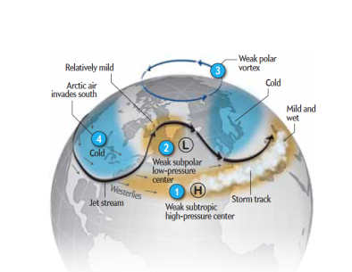
Arctic warming may destabilize circulation patterns, weakening the polar vortex
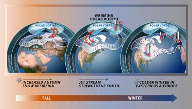
In recent years, the polar jet stream has slowed, its winds have weakened, and its north-south waves, known as Rossby waves (which bring Arctic air to the US) may be getting bigger and occurring more frequently. For three consecutive winters, starting in December 2012, the jet stream has had significant north-south Rossby waves. In the East, the jet stream has been dipping unusually far south, creating a low “trough” that brings down cool Arctic air.
Arctic researchers have recently begun to study the effects of rapid warming in the Arctic and their possible link to jet stream behavior and mid-latitude weather conditions. The Arctic Ocean has experienced rapid sea ice loss due to global warming at a rate of 11 percent per decade since 1979. This has created an expanse of newly available ocean water to absorb the Sun’s energy. The extra energy has created conditions that are conducive to even more warmth, creating a positive feedback effect known as Arctic amplification. With changes in cloud cover, more atmospheric water vapor, and more heat creeping in from warmer latitudes below, the Arctic has been warming at a rate twice as fast as lower latitudes.
Sea ice loss may be linked to changes in Northern Hemisphere circulation
In 2012, climate scientists Jennifer Francis and Stephen Vavrus proposed that Arctic amplification driven by sea ice loss could significantly affect mid-latitude weather by decreasing the temperature gradient between mid-latitudes and the Arctic, causing the jet stream’s winds to slowdown and waves to meander. A 2015 paper by Francis and Vavrus tests this theory further and finds that as the Arctic warms faster than the rest of the planet, the frequency of extreme weather events caused by persistent jet stream patterns will increase.
Scientists are identifying additional mechanisms that may be contributing to the unusual mid-latitude weather. All sea ice studies agree that the loss of sea ice warms the Arctic atmosphere and increases moisture content, but scientists have identified different ways that the atmosphere may be responding to the loss of ice and resulting temperature increase. For example, a team led by Judah Cohen has proposed a chain of events where less Arctic sea ice and more open water cause the atmosphere to heat, which leads to more snow cover in Siberia in October, cooling the atmosphere and forcing the meandering jet stream pattern we are currently seeing.
Related Content