Abnormally warm Gulf of Mexico could intensify the upcoming tornado and hurricane seasons
Climate Signals Summary: Climate change is increasing ocean temperatures, which means there is more energy to fuel storms. Hurricane Harvey was fueled by abnormally warm ocean temperatures, and climate change also increased the amount of rain the storm dumped.
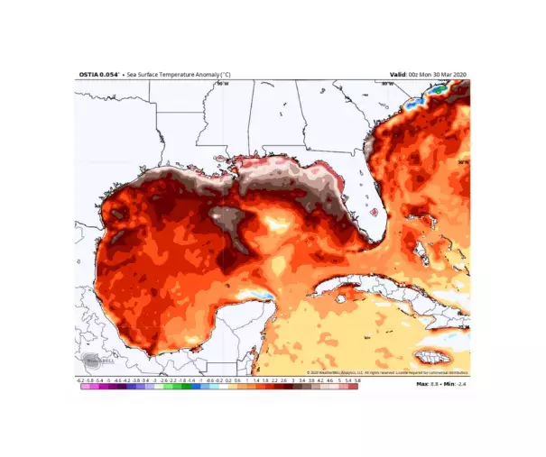
Article Excerpt: Water temperatures in the Gulf of Mexico are running more than three degrees above average, increasing the prospects for severe thunderstorms and tornadoes this spring and potentially stronger hurricane activity in the summer and fall.
The last time Gulf of Mexico waters were similarly warm in 2017, it coincided with an above-average tornado season through the spring, and then Category 4 Hurricane Harvey struck the Texas Gulf Coast at the end of summer.
The balmy gulf waters have already contributed to abnormal warmth across the Deep South, where virtually the entirety of the Interstate 10 corridor through Texas, Louisiana, Mississippi, Alabama and Georgia is wrapping up one of its top five warmest Marches on record. Numerous records have toppled, with some cities soaring into the 90s.
...
The annual barrage of tempestuous fury stems from the volatile clash of shifting seasons. As springtime warmth begins to build in the Gulf of Mexico, surges of mild air meander north — only to collide with stubbornly persistent cold shots of winter exiting the Rockies. It’s that collision that brews severe thunderstorms and tornadoes.
Warmer water temperatures supply the atmosphere with added warmth and moisture, bolstering instability — or the energy to “lift” pockets of warm air into chillier air overhead. That in theory favors stronger and more widespread updrafts and thunderstorms and could slightly tip the scales in favor of increased severe thunderstorm and tornado chances.
...
There is no way to tell whether sea surface temperatures in the Gulf of Mexico will be running quite as toasty during hurricane season — which peaks in September. But it is likely that the gulf will be a good deal warmer than average.
Warm water temperatures fuel tropical cyclones. Experts have long since warned that the warming climate will favor stronger hurricanes.
...
Any storms that do form could also feature more rainfall and flood potential. The warmer gulf means that air in contact with the gulf is warmer. As a result, it has the capacity to carry more moisture.
Some studies have pointed to this coming into play to catalyze Hurricane Harvey’s historic flooding across Texas and Louisiana in 2017. According to a paper published in 2018 in the journal Earth’s Future, Gulf of Mexico water temperatures before Harvey were warmer than any time on record — “supercharging” the devastating rainfall that occurred.
“Ocean heat content was the highest on record both globally and in the Gulf of Mexico,” the authors noted. “Ocean heat was realized in the atmosphere as moisture, and then as latent heat in record‐breaking heavy rainfalls. Accordingly, record high ocean heat values not only increased the fuel available to sustain and intensify Harvey but also increased its flooding rains on land.”
The study ominously concluded that “Harvey could not have produced so much rain without human‐induced climate change.”
There is also an increased risk of storms undergoing rapid intensification over extra-warm waters. It has been widely noted that more tropical cyclones are rapidly intensifying (their winds increasing by at least 35 mph in 24 hours), and warmer waters may be playing a role.
Related Content