Category 4 Kenneth Crashes Ashore in Mozambique; Devastating Rains Still to Come
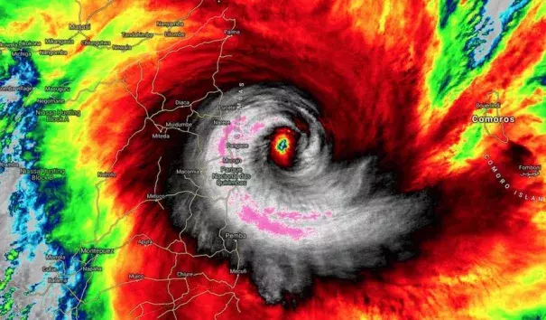
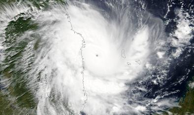
Tropical Cyclone Kenneth slammed onto the coast of far northern Mozambique around 4 pm Thursday afternoon local time (10:15 am EDT) as a potentially catastrophic Category 4 storm. Just before landfall, at 12Z (8 am EDT), Kenneth’s top sustained winds were pegged at 120 knots (140 mph)—solidly in the Cat 4 range—by the Joint Typhoon Warning Center. The agency issuing the official forecasts for the South Indian Ocean, RSMC-La Reunion, put Kenneth’s top winds at 12Z at 110 knots (125 mph), but this is a 10-minute average, a value tends to run slightly lower than the 1-minute average used by JTWC and by the U.S. National Hurricane Center. At its peak, Kenneth was classified as an intense tropical cyclone, the second highest rating on the seven-point scale used in the Southwest Indian Ocean.
The cyclone made landfall at the northern end of Mozambique’s Quirimbas National Park, a thinly populated area but with a number of villages with no experience of a storm of this magnitude. The stronger southern side of Kenneth’s eyewall was focused in this region. The Quisanga Islands, which includes several resorts, were likely quite hard hit by Kenneth’s winds and by a storm surge that could have been as high as 3 -5 meters (10 – 16 feet), according to RSMC-La Reunion.
Kenneth has been a very compact cyclone, which facilitated its rapid growth from tropical storm to Category 4 strength in just 36 hours. As Kenneth approached the coast, its hurricane-force winds extended only about 40-45 miles to the south and 30-35 miles to the north. At the city of Pemba, about 60 miles south of where Kenneth made landfall, top sustained winds at the time were only about 27 mph, with gusts to 39 mph.
An unprecedented event for northern Mozambique
In records going back 50 years, far northern Mozambique has no record of storms of even minimal hurricane strength, much less a system as powerful as Kenneth. The landfall location (12°S) is quite close to the equator, in a latitude range where it becomes more difficult for cyclones to gather enough atmospheric spin to develop. Only a couple of tropical depressions and tropical storms have made landfall this far north in Mozambique or in Tanzania in the several decades of satellite coverage.
Kenneth ranks among the strongest landfalls on record for the entire African mainland. Cyclone Leon-Eline struck Mozambique on Feb. 26, 2000, with top one-minute sustained winds of 134 mph as assessed by JTWC. Off the mainland, Cyclones Hary (2000) and Gafilo (2004) both struck Madagascar at Category 5 strength, with top sustained winds of 160 mph, according to JTWC.
Kenneth is smaller but more intense than Tropical Cyclone Idai, which made a catastrophic landfall in central Mozambique near the city of Beira on March 15. Idai peaked offshore as a Category 3 storm—with top sustained winds of 120 mph, according to JWTC—and made landfall as a Category 2 with top winds of 105 mph. In modern satellite-era records, Mozambique has never recorded two Cat 2 or stronger landfalls in the same year. The closest analog to this year would be in 2000, when Cyclone Eline (Leon-Eline) struck south of Beira as a Category 4 on February 22), followed by Cyclone Hudah, which struck further north, near Pebane, as a Category 1 storm on April 8.
Related Content